
Gaer, Newport facts for kids
Quick facts for kids Gaer |
|
|---|---|
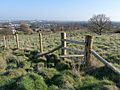
 Looking north towards Twmbarlwm |
|

Gaer
|
|
| Population | 8,721 (2011 census) |
| Language | English Cymraeg (Welsh) |
| OS grid reference | ST295865 |
| Principal area | |
| Country | Wales |
| Sovereign state | United Kingdom |
| Post town | NEWPORT |
| Postcode district | NP20 3 |
| Dialling code | 01633 Maesglas exchange |
| Ambulance | Welsh |
| EU Parliament | Wales |
| UK Parliament |
|
| Welsh Assembly |
|
Gaer, also known as Y Gaer in Welsh, is a special part of the city of Newport in South Wales. It's like a neighborhood or a local area, and it's also an "electoral ward." This means people living here vote for their local representatives.
Contents
Discovering Gaer
Gaer is made up of two main areas: the Gaer and Maesglas estates. It does not include the Ebbw Bridge area. This community is an important part of Newport.
The Gaer Hillfort
To the southwest of Gaer, there is an amazing ancient site called the Gaer Hillfort. Sometimes it's also known as the Gollars. A hillfort is a large, old fort built on top of a hill. People used these forts for protection a very long time ago.
This hillfort offers incredible views. You can look south across the River Severn all the way to England. To the north, you can see the mountains of Twmbarlwm and Mynydd Machen. Experts believe this hillfort was built during the Iron Age. The Iron Age was a time in history when people started using iron to make tools and weapons.
Gaer House History
The original Gaer House in this area has a long history. It was built during the time of Queen Elizabeth I. This was a famous queen who ruled England from 1558 to 1603. The house was built by Alexander Seys, who was a member of a well-known family from Boverton.
Gaer's Location and Boundaries
Gaer is surrounded by several important landmarks. To the north, you'll find Bassaleg Road. The South Wales Main Line, which is a major railway line, runs along its eastern side. The Ebbw River forms the southeast boundary. Cardiff Road is to the southwest, and the M4 motorway is to the west. These boundaries help define the area of Gaer.
Images for kids
-
Gaer Hillfort

