
Twmbarlwm facts for kids
Quick facts for kids Twmbarlwm |
|
|---|---|

Twmbarlwm
|
|
| Highest point | |
| Elevation | 419 m (1,375 ft) |
| Prominence | 48 m (157 ft) |
| Geography | |

Twmbarlwm
Location in Wales
|
|
| OS grid | ST242926 |
| Topo map | OS Landranger 171 |
| Official name | Twm-Barlwm Mound and Bailey Castle |
| Designated | 15 September 1933 |
| Reference no. | MM044 |
Twmbarlwm, also known as Twm Barlwm or Twyn Barlwm, is a famous hill in South Wales. People sometimes call it "the Twmp" because of the mound at its top. This hill is located about 2 kilometers (1.2 miles) northeast of Risca.
Even though some people call it a mountain, Twmbarlwm is actually a hill. This is because it stands at 419 meters (1,375 feet) high, which is less than 600 meters (about 2,000 feet). It is a well-known landmark that you can see from many places in the area. From its top, you get amazing views across the M4 motorway area. You can also see over cities like Newport and Cwmbran, and even out to the Bristol Channel.
Contents
Exploring Twmbarlwm's Past
Twmbarlwm has a long and interesting history. It has been an important place for people for thousands of years. The hill holds clues about ancient tribes and medieval castles.
Ancient Hillfort and the Silures Tribe
At the very top of Twmbarlwm, you can find the remains of an ancient hillfort. Experts believe this fort was built during the Iron Age. This was a time in history when people started using iron tools and weapons. The fort was likely built by the Silures. They were a powerful Celtic tribe who lived in this part of Wales. They were here before and during the time of the Roman Empire. The local people of Risca and Cwmcarn still call the hill "The Tump" because of these old remains.
Roman and Norman Connections
After the Silures, there might have been a Roman signal point on Twmbarlwm. This would have been a place where Roman soldiers could send messages. Later, a large Norman motte-and-bailey castle was built here. This type of castle has a mound (motte) with a tower and a walled courtyard (bailey). The Norman castle was built into the eastern part of the older hillfort. It was likely constructed in the early Norman period, after the Normans came to Britain.
A Protected Historical Site
Today, the area around Twmbarlwm is a scheduled monument. This means it is a very important historical site. The government protects it to make sure these ancient remains are preserved for future generations. It helps us learn about the people who lived here long ago.
Images for kids
-
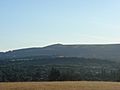
Twmbarlwm seen from Llanfrechfa
-
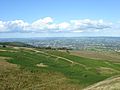
View from Twmbarlwm over Cwmbran
-
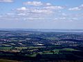
View over the Bristol Channel with the Severn motorway bridges in the distance
-
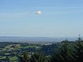
View from Twmbarlwm over the Bristol Channel towards England. Brean Down is in the centre of the photo. Weston-super-Mare is out of sight in the bay to the left of Brean Down.


See also
