Gagebrook, Tasmania facts for kids
Quick facts for kids GagebrookHobart, Tasmania |
|||||||||||||||
|---|---|---|---|---|---|---|---|---|---|---|---|---|---|---|---|

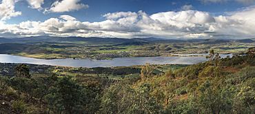
Bridgewater (left) and Gagebrook (right)
|
|||||||||||||||
| Population | 1,440 (2016 census) | ||||||||||||||
| Postcode(s) | 7030 | ||||||||||||||
| Location | 9 km (6 mi) S of Brighton | ||||||||||||||
| LGA(s) | Brighton | ||||||||||||||
| Region | Hobart | ||||||||||||||
| State electorate(s) | Lyons | ||||||||||||||
| Federal Division(s) | Lyons | ||||||||||||||
|
|||||||||||||||
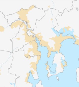
Gagebrook is a suburb in Tasmania, Australia. It's a residential area, meaning people live there. Gagebrook is part of the Brighton local government area, which is near Hobart. In 2016, about 1440 people lived in Gagebrook. You can find it on the eastern side of the Derwent River, close to other suburbs like Bridgewater and Old Beach.
Gagebrook's History
Gagebrook officially became a suburb in 1977. It was developed with many homes built by the government. These homes were for families who needed affordable places to live. Over time, some of these government-built homes have been sold to private owners.
Schools in Gagebrook
Gagebrook has two primary schools for younger students. These are Herdman's Cove Primary School and Gagebrook Primary School. Both are public schools.
Gagebrook's Geography
The Jordan River forms the western and north-western edges of Gagebrook. This river helps to create the natural boundaries of the suburb.
Getting Around Gagebrook
Route B32, also known as the East Derwent Highway, passes by the southern part of Gagebrook. From this main road, you can use Gage Road and Tottenham Road to enter the suburb. These roads help people travel in and out of the area.
 | Janet Taylor Pickett |
 | Synthia Saint James |
 | Howardena Pindell |
 | Faith Ringgold |


