Galdames facts for kids
Quick facts for kids
Galdames
|
||
|---|---|---|

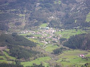
View from Serantes
|
||
|
||
| Country | Spain | |
| Autonomous community | Basque Country | |
| Province | Biscay | |
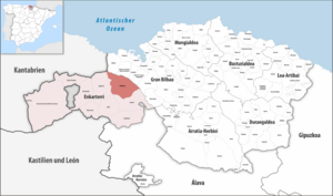
| Comarca | Enkarterri | |
| Area | ||
| • Total | 44.36 km2 (17.13 sq mi) | |
| Elevation | 166 m (545 ft) | |
| Population
(2018)
|
||
| • Total | 829 | |
| • Density | 18.688/km2 (48.40/sq mi) | |
| Demonym(s) | galdamestarra | |
| Time zone | UTC+1 (CET) | |
| • Summer (DST) | UTC+2 (CEST) | |
| Postal code |
48191
|
|
| Official language(s) | Basque, Spanish | |
Galdames is a cool town and valley in the Basque Country, Spain. It's located in the Biscay province.
This area is known for its amazing caves, like Santa Maria Magdalena and Arenaza. These caves are found in the Triano mountain range. The Arenaza cave has awesome rock formations called stalactites and signs of old mining work. You can also visit the medieval Torre Loizaga (Loizaga Tower) in Concejuelo. It's now home to a museum filled with classic cars!
Contents
A Look Back: Galdames' History
Galdames was first mentioned in official papers way back in 1214. During the Middle Ages, many important families and lords lived here. You can still see their old towers, like those of the Loizaga, Atxurriaga, and Larrea families.
Joining the Lordship
The local council of Galdames wanted to be part of the Lordship of Biscay. This was a powerful group of towns and lands. Galdames finally joined them in 1672. Later, in 1740, the council left the Lordship, but they rejoined in 1800.
Times of Change and Growth
During the First Carlist War, some forests around San Pedro Galdames were burned. From the 1800s to the mid-1900s, Galdames became very rich. This was because of all the valuable minerals found under the valley.
In 1946, a group called the Spanish Maquis came back from the Cantabrian mountains. They built a secret shelter in the Uraiaga cave and the nearby mines.
Exploring the Geography of Galdames

Galdames is in the northeast part of a region called Enkarterri. It shares borders with several other towns. These include Sopuerta, Zalla, and Gueñes in Enkarterri. It also borders Muskiz, Abanto y Ciérvana-Abanto Zierbena, Ortuella, Valle de Trápaga-Trapagaran, and Barakaldo in Gran Bilbao.
Mountains and Rivers
The town of Galdames is in a valley that runs from west-northwest to east-southeast. This valley is part of the Basque Mountains. Some tall mountains overlook the valley, like Pico Mayor, Ganeran, Luxar, and Larrea.
Galdames Creek flows through the valley towards the northwest. It then joins the Barbadun River in Montellano. From there, the Barbadun River flows north into the town of Muskiz.
Population: How Many People Live Here?
| Population of Galdames | ||
|---|---|---|
| Year | Pop. | ±% |
| 1900 | 2,886 | — |
| 1910 | 3,856 | +33.6% |
| 1920 | 3,854 | −0.1% |
| 1930 | 3,335 | −13.5% |
| 1940 | 3,022 | −9.4% |
| 1950 | 2,312 | −23.5% |
| 1960 | 1,892 | −18.2% |
| 1970 | 1,249 | −34.0% |
| 1981 | 812 | −35.0% |
| 1991 | 799 | −1.6% |
| 2001 | 799 | +0.0% |
| 2011 | 851 | +6.5% |
| 2021 | 831 | −2.4% |
Even though Galdames is close to a big city like Bilbao, its population didn't grow like other nearby towns. In fact, between 1920 and 1981, the number of people living in Galdames went down a lot. After that, the population stayed pretty steady.
As of 2021, Galdames has about 831 people. This is much less than its population in 1920.
Neighborhoods of Galdames
Galdames is split into 8 different neighborhoods or areas. The biggest one is San Pedro Galdames. The other neighborhoods are:
- Atxuriaga (also known as La Aceña)
- Concejuelo
- Humaran
- Larrea
- Montellano
- San Esteban Galdames
- Txabarri
See also
 In Spanish: Galdames para niños
 | Jackie Robinson |
 | Jack Johnson |
 | Althea Gibson |
 | Arthur Ashe |
 | Muhammad Ali |


