Galena, Alaska facts for kids
Quick facts for kids
Galena
Notaalee Denh
|
|
|---|---|

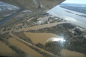
Galena following the 2013 flood
|
|
| Country | United States |
| State | Alaska |
| Census Area | Yukon-Koyukuk |
| Incorporated | October 26, 1971 |
| Area | |
| • Total | 24.51 sq mi (63.47 km2) |
| • Land | 17.65 sq mi (45.72 km2) |
| • Water | 6.85 sq mi (17.75 km2) |
| Elevation | 128 ft (39 m) |
| Population
(2020)
|
|
| • Total | 472 |
| • Density | 26.74/sq mi (10.32/km2) |
| Time zone | UTC-9 (Alaska (AKST)) |
| • Summer (DST) | UTC-8 (AKDT) |
| ZIP code |
99741
|
| Area code | 907 |
| FIPS code | 02-27530 |
| GNIS feature ID | 1402457 |
| Website | http://www.ci.galena.ak.us/ |
Galena (/ɡəˈliːnə/), also known as Notaalee Denh in the Koyukon language, is a small city in Alaska, USA. It is located in the Yukon-Koyukuk Census Area. In 2020, about 472 people lived there. Galena was founded in 1918. A military airfield was built next to the city during World War II. The city officially became a city in 1971.
Contents
History of Galena
Early History and How Galena Got Its Name
Long ago, the Athabascan people, specifically the Koyukon group, lived in this area. They moved around with the seasons to hunt wild animals. In summer, many families would float on rafts to the Yukon River to catch salmon. There were 12 summer fishing camps along the Yukon River.
Galena was started in 1920 near one of these fishing camps called Henry's Point. It became a place to get supplies for nearby lead ore mines. These mines opened in 1918 and 1919, and that's where the city of Galena got its name.
Galena's Military Air Base
During World War II, in 1941 and 1942, a military air field was built next to the local airport. They shared the same runway. After the United States Air Force became its own branch of the military in 1947, this air field was named Galena Air Force Station.
In the 1950s, more military buildings were added. This helped the airport and the local area grow, bringing jobs and money to Galena. The base was used as a special "forward operating base" for military planes.
After the Cold War ended in 1993, a company took over running the Galena Air Force Station. Most military people left, but small groups still visited when needed. The military facility is still used sometimes as a "forward operating site." The base officially closed on October 1, 2010. However, the Air Force is still responsible for cleaning up any old toxins in the area. Engineers from Eielson Air Force Base still visit the site. Today, the City of Galena, the Galena School District, and the Alaska Department of Transportation control the former base.
Recent Times in Galena
Galena became well-known in 2011 because it received a lot of help from special efforts to get state and federal money. This money helped the city avoid financial problems, mainly by supporting the GILA boarding school in town.
In May 2013, Galena faced a huge flood. The spring ice on the Yukon River broke up and caused a big ice jam about 20 miles downstream. This made the river back up and flood about 90% of the homes in the city. It was a flood unlike any Galena residents had seen before. Houses closest to the river were almost completely underwater. Even homes on higher ground were damaged.
Most residents were able to leave safely thanks to local airlines, volunteer pilots, and the Alaska National Guard. Some people chose to stay in the few dry parts of town. A flood wall built by the Air Force around the runway and the GILA boarding school kept them safe from the water. Many groups, including the Federal Emergency Management Agency, helped Galena rebuild after the flood.
Geography and Climate
Galena is located at 64°44′26″N 156°53′8″W / 64.74056°N 156.88556°W. It sits on the north bank of the Yukon River, about 45 miles (72 km) east of Nulato. The Innoko National Wildlife Refuge is to the southwest.
The city covers about 24 square miles (62 square kilometers). About 17.9 square miles (46 square kilometers) is land, and 6.1 square miles (16 square kilometers) is water.
Galena cannot be reached by road from other parts of Alaska. People living there depend on river barges in the short summer for most of their supplies. They use planes, boats, or snowmobiles to travel to other places.
| Climate data for Galena, Alaska (1991–2020 normals, extremes 1942–present) | |||||||||||||
|---|---|---|---|---|---|---|---|---|---|---|---|---|---|
| Month | Jan | Feb | Mar | Apr | May | Jun | Jul | Aug | Sep | Oct | Nov | Dec | Year |
| Record high °F (°C) | 43 (6) |
48 (9) |
50 (10) |
64 (18) |
85 (29) |
92 (33) |
91 (33) |
87 (31) |
75 (24) |
59 (15) |
45 (7) |
44 (7) |
92 (33) |
| Mean maximum °F (°C) | 27.3 (−2.6) |
32.9 (0.5) |
36.5 (2.5) |
53.1 (11.7) |
72.8 (22.7) |
80.7 (27.1) |
82.5 (28.1) |
78.2 (25.7) |
64.0 (17.8) |
47.1 (8.4) |
30.5 (−0.8) |
26.1 (−3.3) |
84.4 (29.1) |
| Mean daily maximum °F (°C) | −2.7 (−19.3) |
9.0 (−12.8) |
18.6 (−7.4) |
37.7 (3.2) |
56.6 (13.7) |
68.7 (20.4) |
69.4 (20.8) |
62.4 (16.9) |
51.7 (10.9) |
31.4 (−0.3) |
11.6 (−11.3) |
2.7 (−16.3) |
34.8 (1.6) |
| Daily mean °F (°C) | −9.8 (−23.2) |
−0.3 (−17.9) |
6.9 (−13.9) |
27.2 (−2.7) |
45.6 (7.6) |
58.0 (14.4) |
60.2 (15.7) |
54.0 (12.2) |
43.5 (6.4) |
25.5 (−3.6) |
5.5 (−14.7) |
−4.4 (−20.2) |
26.0 (−3.3) |
| Mean daily minimum °F (°C) | −16.8 (−27.1) |
−9.5 (−23.1) |
−4.8 (−20.4) |
16.8 (−8.4) |
34.6 (1.4) |
47.3 (8.5) |
51.1 (10.6) |
45.6 (7.6) |
35.4 (1.9) |
19.6 (−6.9) |
−0.6 (−18.1) |
−11.5 (−24.2) |
17.3 (−8.2) |
| Mean minimum °F (°C) | −49.6 (−45.3) |
−41.1 (−40.6) |
−28.1 (−33.4) |
−9.5 (−23.1) |
19.4 (−7.0) |
37.3 (2.9) |
41.2 (5.1) |
33.3 (0.7) |
21.7 (−5.7) |
−2.9 (−19.4) |
−26.3 (−32.4) |
−39.5 (−39.7) |
−51.3 (−46.3) |
| Record low °F (°C) | −70 (−57) |
−64 (−53) |
−54 (−48) |
−35 (−37) |
−7 (−22) |
25 (−4) |
28 (−2) |
28 (−2) |
2 (−17) |
−31 (−35) |
−52 (−47) |
−62 (−52) |
−70 (−57) |
| Average precipitation inches (mm) | 0.60 (15) |
0.75 (19) |
0.59 (15) |
0.33 (8.4) |
0.44 (11) |
1.59 (40) |
2.04 (52) |
2.47 (63) |
1.75 (44) |
1.18 (30) |
1.24 (31) |
0.95 (24) |
13.93 (354) |
| Average snowfall inches (cm) | 11.0 (28) |
14.9 (38) |
9.1 (23) |
4.6 (12) |
0.4 (1.0) |
0.0 (0.0) |
0.0 (0.0) |
0.0 (0.0) |
0.3 (0.76) |
8.3 (21) |
12.8 (33) |
15.8 (40) |
77.2 (196) |
| Average precipitation days (≥ 0.01 inch) | 7.4 | 9.4 | 7.0 | 5.6 | 6.0 | 9.3 | 11.2 | 14.5 | 11.9 | 11.1 | 10.0 | 10.8 | 114.2 |
| Average snowy days (≥ 0.1 inch) | 7.5 | 9.2 | 6.8 | 4.0 | 0.4 | 0.0 | 0.0 | 0.0 | 0.2 | 6.7 | 9.9 | 10.9 | 55.6 |
| Source: NOAA | |||||||||||||
People of Galena (Demographics)
| Historical population | |||
|---|---|---|---|
| Census | Pop. | %± | |
| 1890 | 15 | — | |
| 1930 | 67 | — | |
| 1940 | 44 | −34.3% | |
| 1950 | 176 | 300.0% | |
| 1960 | 261 | 48.3% | |
| 1970 | 302 | 15.7% | |
| 1980 | 765 | 153.3% | |
| 1990 | 833 | 8.9% | |
| 2000 | 675 | −19.0% | |
| 2010 | 470 | −30.4% | |
| 2020 | 472 | 0.4% | |
| U.S. Decennial Census | |||
Galena first appeared in the U.S. Census in 1890 as "Notaloten." It didn't appear again until 1930, when it was called Galena. It officially became a city in 1971.
In 2010, there were 470 people living in Galena. Most residents were Native American (63.6%) or White (29.4%). About 29.3% of the people were under 18 years old. The average age was about 36.8 years.
Education in Galena
Galena runs its own schools because it is a "first-class city" in Alaska. This means it has its own school district, called the Galena City School District. Like some other cities in Alaska, Galena's school district has a boarding school and a program for students who study from home. This helps the schools get more funding from the state.
Galena has three schools:
- Galena City School is mainly for local students from kindergarten through 12th grade. It has a public library inside the Sidney C. Huntington School. Sidney Huntington was a well-known leader in Galena and wrote a popular book about Alaska.
- The Galena Interior Learning Academy (GILA) is a boarding school. Students from all over Alaska, especially from remote Native Alaskan villages, come here for grades 9-12. GILA is on the site of the old Galena Air Force Station. It uses former military buildings like barracks for dorms and old offices for classrooms. GILA helps young people get both regular education and job training.
- Interior Distance Education of Alaska (IDEA) is a program that supports about 3,500 students across Alaska who learn from home. It is considered the largest school in Alaska by the number of students enrolled.
Transportation and Services
Galena's Edward G. Pitka Sr. Airport (Code GAL) used to be the Galena Air Force Station field. It has a paved runway over 8000 feet long, making it one of the largest public airports in Interior Alaska. A small plane used for search and rescue is kept at the airport.
Large items like oil, vehicles, and building materials are brought to Galena by river barge during the summer.
The City of Galena provides important services like water and sewer. The city also owns the Nollner Health Clinic. This clinic offers 24-hour emergency care and regular health services. Doctors for eye and dental care visit Galena regularly. If someone has a serious medical emergency, they are taken to the clinic and then flown by air ambulance to larger hospitals in Fairbanks or Anchorage.
Galena also has its own public radio station, KIYU-FM.
Sports in Galena
Galena is a stop on famous Alaskan races:
- The Iditarod Trail Sled Dog Race passes through Galena every other year.
- The Tesoro Iron Dog snowmobile race also goes through Galena.
- Galena is the halfway point for the Yukon 800, an annual summer speedboat race that starts in Fairbanks.
Galena schools offer many sports for students, including:
- Volleyball
- Cross-country running
- Basketball
- Swimming
- Skiing
- Native Youth Olympics (NYO)
The Galena high school boys' and girls' basketball teams were regional champions from 2004 to 2007. The boys' basketball team even won the state championship in 2008!
See also
 In Spanish: Galena (Alaska) para niños
 | Bessie Coleman |
 | Spann Watson |
 | Jill E. Brown |
 | Sherman W. White |


