
Gap of Dunloe facts for kids
Quick facts for kids Gap of Dunloe |
|
|---|---|
| Dún Lóich | |

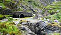
At the Black Lake in the Gap of Dunloe, looking south towards the Head of the Gap
|
|
| Elevation | 241 metres (791 feet) |
| Traversed by | Public Road |
| Location | County Kerry, Ireland |
| Range | |
| Coordinates | 52°1′00″N 9°38′7.8″W / 52.01667°N 9.635500°W |
| Topo map | OSI Discovery 78 |

Location in Ireland
|
|
The Gap of Dunloe is a beautiful, narrow mountain pass in County Kerry, Ireland. It runs from north to south, separating two big mountain ranges: the MacGillycuddy's Reeks in the west and the Purple Mountain Group in the east. This stunning area is one of Ireland's most popular places for tourists to visit because of its amazing views.
Contents
What's in a Name? The Gap of Dunloe's History

The name "Dunloe" comes from the Irish words "Dún Lóich." This means "fort" or "stronghold of Lóich." The River Loe, which flows through the Gap, also gets its name from Lóich.
Ancient Irish stories tell us about a person named Deala Mac Lóich. He was the father of five leaders of the Fir Bolg people. The Fir Bolg were an early group who came to Ireland. They divided the country into five parts, with each brother ruling one. These stories say the Fir Bolg ruled Ireland for 37 years, from 3266 to 3303 B.C. Later, another group called the Tuatha Dé Danann defeated them.
How the Gap of Dunloe Was Formed
_Gap_of_Dunloe.jpg)
The Gap of Dunloe was created about 25,000 years ago. This happened during Ireland's last ice age. A huge glacier, over 500 meters deep, broke through the "Head of the Gap." It then moved north, carving out the deep, U-shaped valley you see today. This process is called a "glacial breach."
Exploring the Gap: Mountains, Lakes, and Roads
The pass runs between two mountain ranges made of Old Red Sandstone. To the west are the MacGillycuddy's Reeks. To the east is the Purple Mountain Group.
The road through the Gap is often called "The Gap." It starts at Kate Kearney's Cottage in the north. It goes up to the highest point, called the Head of the Gap, which is 241 meters high. Then, it goes down to Lord Brandon's Cottage in the Black Valley in the south. The whole road from Kate Kearney's Cottage to Lord Brandon's Cottage is 11 kilometers long. Along this path, the elevation changes by about 200 meters.
Inside the Gap, there are five beautiful lakes. From north to south, they are Coosaun Lough, Black Lake, Cushnavally Lake, Auger Lake, and Black Lough. The River Loe connects all these lakes.
The Wishing Bridge and Scenic Views
Between Coosaun Lough and Black Lake, you'll find the Wishing Bridge. People say that any wish you make while standing on this bridge will come true! There are also stone bridges at the northern ends of Augher Lake and Black Lough. These bridges are great spots to stop and enjoy the amazing views.
Getting Around the Gap of Dunloe
.jpg)
The road through the Gap of Dunloe is a public road. It goes from Kate Kearney's Cottage in the north to the Black Valley in the south. Kerry County Council is in charge of this road.
Sometimes, there has been confusion about whether cars can drive on the road. In 2005, some private horse-drawn carriage operators were accused of trying to stop tourists from driving. However, travel guides like Lonely Planet have confirmed that the road is indeed public.
.jpg)
Reaching the Head of the Gap
You can get to the true Head of the Gap from the north by driving past Kate Kearney's Cottage. If you're coming from the south, you can drive to Moll's Gap. Then, continue east on the R568 road. You'll find a small side-road that goes steeply down into the Black Valley. This road then winds west towards Lord Brandon's Cottage and finally turns north to the Head of the Gap. This route is part of a 55-kilometer loop that cyclists love to ride.
Safety on the Narrow Roads
As the public road reaches the Head of the Gap, it becomes very narrow and winding. This can make it difficult for vehicles to pass each other. Because of this, there have been safety concerns. It's important to be careful when traveling through this part of the Gap.
Activities in the Gap: Walking and Climbing
Hill Walking Adventures
The mountain ranges on both sides of the Gap are popular for hill walking. The MacGillycuddy's Reeks are to the west, and the Purple Mountain Group are to the east.
A popular walk is from Kate Kearney's Cottage to the Head of the Gap. This walk is 6 kilometers long and takes about 1 hour one way. So, a round trip back to Kate Kearney's Cottage would take about 2 hours.
Rock Climbing Challenges

The Gap of Dunloe is also a place for rock climbing, though it's not as famous as some other spots in Ireland. There are many cliffs and crags made of Old Red Sandstone that climbers use. Over 107 climbing routes are listed and graded online.
Most of the climbing spots are on the north-west side of the valley. You'll find them near Brennan's Leap and the Wishing Bridge. There are also two crags on the east side called Céim and Bothán. The climbs here range from easy to very difficult. Some climbs are over 30 meters long!
The Gap is also considered one of the top 5 places in Ireland for bouldering. Bouldering is a type of rock climbing done on smaller rocks or low cliffs without ropes.
Images for kids
-
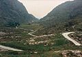
At the Head of the Gap (highest point) looking northwards
-
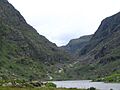
Looking southwards across Augher Lake up into the Head of the Gap
-
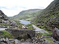
Looking northwards at the road down to Augher Lake
-
Looking southwards across Augher Lake up into the Head of the Gap
-
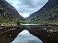
Looking northwards to the stone bridge before Black Lough


_Gap_of_Dunloe.jpg)
.jpg)
