Moll's Gap facts for kids
Quick facts for kids Moll's Gap |
|
|---|---|
| Céim an Daimh | |

Moll's Gap
|
|
| Elevation | 260 metres (850 feet) |
| Traversed by | N71 road |
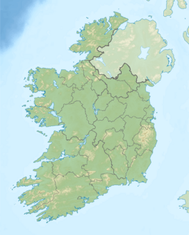
| Location | County Kerry, Ireland |
| Range | MacGillycuddy's Reeks |
| Coordinates | 51°56′17″N 9°39′27″W / 51.93818°N 9.657412°W |
| Topo map | OSI Discovery 78 |
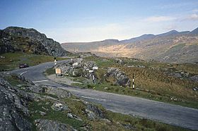
Moll's Gap, also known as Céim an Daimh (which means 'Gap of the Ox' in Irish), is a famous mountain pass in County Kerry, Ireland. It's located on the N71 road, connecting the towns of Kenmare and Killarney.
Discovering Moll's Gap
Moll's Gap is a popular spot for tourists and is part of the scenic Ring of Kerry driving route. From here, you can enjoy amazing views of the MacGillycuddy's Reeks mountains, which are the tallest in Ireland. It's a great place to stop and take photos of the beautiful Irish landscape.
How Moll's Gap Got Its Name
The pass is named after a woman called Moll Kissane. Back in the 1820s, when the road was being built, Moll ran a small place where workers could rest and get refreshments. This made her a well-known person in the area, and so the gap was named after her.
The Story of the Rocks
The rocks you see at Moll's Gap are made of something called Old Red Sandstone. These rocks formed over 350 million years ago from tiny grains of quartz. What's special about the sandstone here is its color. While most Old Red Sandstone around Killarney looks red because of iron, the rocks at Moll's Gap are stained green. This green color comes from a mineral called chlorite.
A Glacial Past
Moll's Gap has an interesting geological history, shaped by ice! About 25,000 years ago, during Ireland's last ice age, a huge glacier moved through the area. This glacier was about 500 meters deep and came from the Black Valley. It pushed its way through Moll's Gap, creating what scientists call a "glacial breach." This powerful movement of ice carved out the landscape you see today.
 | Calvin Brent |
 | Walter T. Bailey |
 | Martha Cassell Thompson |
 | Alberta Jeannette Cassell |


