Garrison Grist Mill Historic District facts for kids
Quick facts for kids |
|
|
Garrison Grist Mill Historic District
|
|

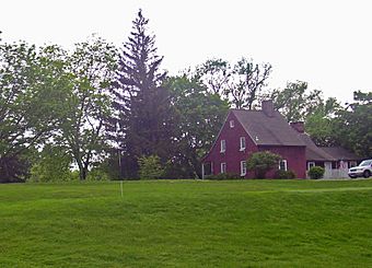
Frame cottage visible from NY 9D,
with green in foreground, 2008 |
|
| Location | Garrison, NY |
|---|---|
| Nearest city | Peekskill |
| Area | 13.4 acres (5.4 ha) |
| Built | Colonial era |
| Architectural style | Dutch Colonial |
| NRHP reference No. | 93001434 |
| Added to NRHP | 1993 |
The Garrison Grist Mill Historic District is a special area in Garrison, New York. It covers about 13.4 acres (5.4 hectares) and is part of the Highlands Country Club. This district is home to three very old buildings and a dam. These structures date back to the time when America was still a group of colonies or just after it became independent.
The main building is an old gristmill, which is a mill that grinds grain into flour. It's thought to be one of the oldest mills in Putnam County. The buildings are spread out within the golf course. They are actually owned by the Open Space Institute, a group that helps protect important lands.
Not much is known about who built these structures or exactly when. However, their style suggests they are some of the oldest buildings in Garrison. They show a simple, local building style from that time. Because of their history, they were added to the National Register of Historic Places in 1992. This means they are recognized as important historical sites.
Contents
Exploring the Historic Buildings
The Garrison Grist Mill Historic District is located where Route 9D meets Lower Station Road. It's bordered by Arden Brook to the south. Other historic places are nearby, like The Birches and the Mandeville House. The Garrison Landing Historic District and the train station are also close by. Even Castle Rock can be seen from here!
The district includes three main buildings and a dam. All of these are considered important parts of the historic site.
The Farmhouse
The most noticeable building is a red farmhouse. It has one and a half stories and can be seen from the nearby intersection. It sits on a small hill that slopes down towards the Hudson River. The outside of the house has shingles over older wooden siding. Inside, the main part of the house still looks much like it did originally.
The Barn
About 500 feet (150 meters) south of the farmhouse, you'll find a New World Dutch barn. This barn is built in a traditional wood-frame style. It has large doors at each end, which were used for wagons. The outside of the barn is covered in weathered wooden boards.
The Gristmill
Near the barn, there's a millpond. At the other end of the pond is the gristmill itself. This building has two and a half stories. Part of it has been changed into an apartment. Over the years, the mill has had some renovations and also some wear and tear.
The Dam
The last important structure in the district is the dam. It's made from stone that was dug up nearby. The dam starts about 50 feet (15 meters) east of the mill. It follows the natural slope of the land.
A Look Back in Time: The History of the Mill
It's a bit of a mystery when exactly the mill, barn, and farmhouse were built. Early records and maps of the Garrison area don't mention them much. However, the way they are built and the materials used suggest they were constructed in the mid-to-late 1700s. Some similar buildings in the Hudson Valley were built as late as 1820. The farmhouse's building style is more common in areas closer to New York City, which were settled earlier.
The first known landowner in this area was Jacob Mandeville. He was a businessman from New York City. In 1735, he leased a large piece of land and built his home, which is still standing just outside the district. It's possible he built the farm and mill before the American Revolution, but there are no records to prove it.
Jacob Mandeville's landlord was Beverley Robinson. Robinson was a Loyalist during the American Revolution, meaning he supported the British King. His lands were taken away during the war. After the American colonists won, Robinson left for England. Mandeville was allowed to live on his leased property. After he died in 1784, his son-in-law, Joshua Nelson, bought the land.
Nelson divided the property into smaller pieces. In 1792, he sold the 70-acre (28-hectare) section that includes the historic district. This land then passed through several other owners. They likely continued to farm and use the mill. The last family to own it for a long time was the Arden family, who bought it in 1820. They owned it for the rest of the 1800s.
In 1899, a local group called the Ardenia Corporation bought the property. Soon after, they leased it to the new Highlands Country Club. The club began using the land as part of its golf course.
Even as Garrison became a popular place for large riverside estates, these old properties remained mostly untouched. In 1934, a man named Thomas Hotchkiss visited the "Galloway Farmhouse." He worked for the Historic American Buildings Survey. He wrote a short report and took photos and made sketches. Hotchkiss noticed how unique it was that such old buildings had survived all the new development in the area. He documented some features, like the mill wheel's gears, which are now gone.
In 1986, the Open Space Institute (OSI) took control of the property. It became part of the 71-acre (29-hectare) Arden Point State Park. OSI renovated the mill. They have allowed the club to continue using the land as a golf course. This helps keep the original farming look of the area.
 | George Robert Carruthers |
 | Patricia Bath |
 | Jan Ernst Matzeliger |
 | Alexander Miles |


