Garvin, Minnesota facts for kids
Quick facts for kids
Garvin, Minnesota
|
|
|---|---|

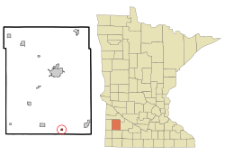
Location of Garvin, Minnesota
|
|
| Country | United States |
| State | Minnesota |
| County | Lyon |
| Government | |
| • Type | Mayor – Council |
| Area | |
| • Total | 0.29 sq mi (0.75 km2) |
| • Land | 0.28 sq mi (0.72 km2) |
| • Water | 0.01 sq mi (0.03 km2) |
| Elevation | 1,539 ft (469 m) |
| Population
(2020)
|
|
| • Total | 124 |
| • Density | 442.86/sq mi (171.23/km2) |
| Time zone | UTC-6 (Central (CST)) |
| • Summer (DST) | UTC-5 (CDT) |
| ZIP code |
56132
|
| Area code(s) | 507 |
| FIPS code | 27-23228 |
| GNIS feature ID | 2394861 |
Garvin is a small city located in Lyon County, Minnesota, in the United States. In 2010, about 135 people lived there. It's a quiet place in the heart of Minnesota.
Contents
The Story of Garvin: A Look Back
Garvin has an interesting past! It was first named "Terry" in honor of a Union general named Alfred Terry. The city's layout was planned by the railroad in 1886.
However, the name changed to Garvin in 1881. This new name honored H. C. Garvin, who was an important official for the railroad company.
Garvin's Location and Size
Garvin is a small city when it comes to its size. The United States Census Bureau helps us measure places like Garvin.
The total area of Garvin is about 0.28 square miles (0.72 square kilometers). Most of this area, about 0.27 square miles (0.70 square kilometers), is land. A very small part, about 0.01 square miles (0.03 square kilometers), is water.
Who Lives in Garvin?
This section talks about the people who live in Garvin. It's called demographics. This word helps us understand the population and its features.
| Historical population | |||
|---|---|---|---|
| Census | Pop. | %± | |
| 1950 | 264 | — | |
| 1960 | 205 | −22.3% | |
| 1970 | 201 | −2.0% | |
| 1980 | 172 | −14.4% | |
| 1990 | 149 | −13.4% | |
| 2000 | 159 | 6.7% | |
| 2010 | 135 | −15.1% | |
| 2020 | 124 | −8.1% | |
| U.S. Decennial Census | |||
Garvin's Population in 2010
The census is like a big count of everyone living in a place. In 2010, the census showed that 135 people lived in Garvin. These people lived in 52 different homes, and 38 of those were families.
The city had about 500 people per square mile (193 people per square kilometer). There were 62 housing units, which are places where people can live.
Most of the people in Garvin were White, making up 97.0% of the population. About 3.0% of the people were from two or more racial backgrounds.
Homes and Families in Garvin
Out of the 52 homes in Garvin:
- About 32.7% had children under 18 living there.
- 55.8% were married couples living together.
- 11.5% had a female head of the household with no husband present.
- 5.8% had a male head of the household with no wife present.
- 26.9% were not families.
About 19.2% of all homes were made up of just one person. On average, there were 2.60 people living in each home. For families, the average size was 2.97 people.
Age Groups in Garvin
The median age in Garvin was 38.5 years old. This means half the people were younger and half were older than 38.5.
Here's a breakdown of the age groups:
- 26.7% of residents were under 18 years old.
- 5.9% were between 18 and 24 years old.
- 27.4% were between 25 and 44 years old.
- 32.5% were between 45 and 64 years old.
- 7.4% were 65 years old or older.
When it comes to gender, 54.1% of the people in Garvin were male, and 45.9% were female.
See also
 In Spanish: Garvin (Minnesota) para niños
 | Toni Morrison |
 | Barack Obama |
 | Martin Luther King Jr. |
 | Ralph Bunche |

