
Geography of Argentina facts for kids

Argentina is a very long country, stretching almost 3,700 kilometers (about 2,300 miles) from north to south. It's also about 1,400 kilometers (870 miles) wide at its widest point. This huge size means Argentina has many different types of land, from flat plains to tall mountains.
The country can be divided into three main areas:
- The Pampas are flat, fertile plains in the central part of Argentina. This area is great for farming.
- Patagonia is in the southern part of the country, all the way down to Tierra del Fuego. This region is known for its cool climate, glaciers, and wide-open spaces.
- The Andes mountain range runs along Argentina's western border with Chile. This is where you'll find some of the world's highest peaks.
Argentina's Tallest Mountains
The highest mountain in Argentina, and in all of the Americas, is Cerro Aconcagua. It stands incredibly tall at 6,960 meters (22,834 feet) above sea level. This giant mountain is located in the Mendoza area.
Important Rivers of Argentina
Argentina has many important rivers that flow through its different regions. The largest river is the Paraná. Other major rivers include the River Plate, Paraguay, Bermejo, Colorado, and Uruguay. These rivers are important for transportation, farming, and providing water.
Images for kids
-
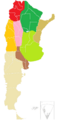
Regions of Argentina: Northwest Chaco Region Mesopotamia Cuyo Sierras pampeanas Pampas Dry Pampas Patagonia Antarctica islands.
-
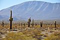
Los Cardones National Park
-
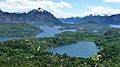
Nahuel Huapi National Park
-
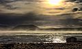
Laguna Blanca National Park


.jpg)


See also
 In Spanish: Geografía de la Argentina para niños
