Georgetown, South Australia facts for kids
Quick facts for kids GeorgetownSouth Australia |
|||||||||||||||
|---|---|---|---|---|---|---|---|---|---|---|---|---|---|---|---|

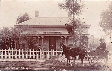
Bank of Adelaide, Georgetown, early 1900s
|
|||||||||||||||
| Postcode(s) | 5472 | ||||||||||||||
| Location |
|
||||||||||||||
| LGA(s) | Northern Areas Council | ||||||||||||||
| State electorate(s) | Frome | ||||||||||||||
| Federal Division(s) | Grey | ||||||||||||||
|
|||||||||||||||
Georgetown is a small town in the Mid North area of South Australia. It is part of the Northern Areas Council. The town is about 196 kilometers (122 miles) north of Adelaide, the state capital. You can find it along the Horrocks Highway.
Contents
Georgetown's Story
Early Days
Georgetown was one of the first towns planned in the upper Mid North region. This happened in 1869. A new law called the Strangways Act was passed that year. This law allowed the government to take back large areas of land. These lands were then divided into smaller sections for more people to settle. The goal was to encourage more intensive farming, where farmers grow more crops on smaller pieces of land. Georgetown was surveyed, or mapped out, at the same time as Redhill.
A Catholic chapel was built and opened in Georgetown in 1872.
Local Government
From 1876 to 1988, Georgetown had its own local government. This was called the District Council of Georgetown. Over time, this council joined with other nearby councils. Today, Georgetown is part of the larger Northern Areas Council.
Getting Around: The Railway
Georgetown used to have a railway line that connected it to Adelaide. This line was part of the Gladstone railway line. It was first built in 1894.
When it was first built, the railway had a narrow gauge. This means the tracks were 3 feet 6 inches (1.07 meters) apart. In 1927, the tracks were changed to a broader gauge. This made them 5 feet 3 inches (1.60 meters) apart. The railway line to Georgetown closed down in 1988.
Weather in Georgetown
| Climate data for Georgetown | |||||||||||||
|---|---|---|---|---|---|---|---|---|---|---|---|---|---|
| Month | Jan | Feb | Mar | Apr | May | Jun | Jul | Aug | Sep | Oct | Nov | Dec | Year |
| Record high °C (°F) | 44.4 (111.9) |
41.7 (107.1) |
40.6 (105.1) |
34.7 (94.5) |
27.3 (81.1) |
26.0 (78.8) |
26.4 (79.5) |
25.2 (77.4) |
33.2 (91.8) |
36.7 (98.1) |
42.2 (108.0) |
43.4 (110.1) |
44.4 (111.9) |
| Mean daily maximum °C (°F) | 31.1 (88.0) |
30.7 (87.3) |
28.1 (82.6) |
22.9 (73.2) |
18.2 (64.8) |
15.0 (59.0) |
14.2 (57.6) |
15.5 (59.9) |
18.7 (65.7) |
22.4 (72.3) |
26.2 (79.2) |
29.2 (84.6) |
22.7 (72.9) |
| Mean daily minimum °C (°F) | 15.0 (59.0) |
15.2 (59.4) |
13.1 (55.6) |
9.8 (49.6) |
7.1 (44.8) |
5.1 (41.2) |
4.2 (39.6) |
4.5 (40.1) |
5.7 (42.3) |
7.8 (46.0) |
10.6 (51.1) |
13.1 (55.6) |
9.3 (48.7) |
| Record low °C (°F) | 4.0 (39.2) |
6.7 (44.1) |
2.8 (37.0) |
0.0 (32.0) |
−0.4 (31.3) |
−3.6 (25.5) |
−6.6 (20.1) |
−2.3 (27.9) |
−2.9 (26.8) |
−0.4 (31.3) |
0.6 (33.1) |
2.2 (36.0) |
−6.6 (20.1) |
| Average rainfall mm (inches) | 20.4 (0.80) |
20.8 (0.82) |
20.4 (0.80) |
35.5 (1.40) |
50.5 (1.99) |
58.4 (2.30) |
57.0 (2.24) |
56.7 (2.23) |
52.7 (2.07) |
44.7 (1.76) |
31.6 (1.24) |
26.0 (1.02) |
474.7 (18.67) |
| Average rainy days (≥ 0.2mm) | 3.1 | 2.9 | 3.6 | 6.1 | 9.2 | 11.3 | 12.4 | 12.3 | 10.0 | 7.9 | 5.5 | 4.4 | 88.7 |
| Source: Bureau of Meteorology | |||||||||||||
 | Emma Amos |
 | Edward Mitchell Bannister |
 | Larry D. Alexander |
 | Ernie Barnes |


