Gilgo-Oak Beach-Captree, New York facts for kids
Quick facts for kids
Gilgo-Oak Beach-Captree, New York
|
|
|---|---|

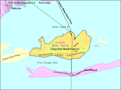
U.S. Census Map
|
|
| Country | United States |
| State | New York |
| County | Suffolk |
| Area | |
| • Total | 3.6 sq mi (9.4 km2) |
| • Land | 2.7 sq mi (7.1 km2) |
| • Water | 0.9 sq mi (2.4 km2) |
| Population
(2000)
|
|
| • Total | 333 |
| • Density | 122.1/sq mi (47.2/km2) |
| Time zone | UTC-5 (Eastern (EST)) |
| • Summer (DST) | UTC-4 (EDT) |
| FIPS code | 36-28997 |
Gilgo-Oak Beach-Captree, often called Oak Beach, was a special area in Suffolk County, New York. It was known as a census-designated place (CDP). This means it was a place the government counted for population, but it wasn't a city or town with its own local government. In the year 2000, about 333 people lived there.
This area was made up of several small beach communities. They were located on a barrier island along the southern coast of Long Island. These communities included West Gilgo Beach, Gilgo Beach, Cedar Beach, Oak Beach, Oak Island, and Captree Island. You could reach them by roads like Ocean Parkway and Robert Moses State Parkway.
Contents
Changes to the Area Over Time
After the 2010 census, the Gilgo-Oak Beach-Captree area was divided into two separate CDPs. These new areas were named Gilgo and Oak Beach–Captree.
Later, before the 2020 census, the Oak Beach-Captree CDP was split again. It became two even smaller CDPs: Oak Beach and Captree. This shows how these beach communities have been recognized in different ways over the years.
Where is Oak Beach Located?
Oak Beach is found at specific geographic coordinates: 40.641100 degrees North and -73.278195 degrees West.
The entire CDP covered about 3.7 square miles (9.4 square kilometers). Most of this area, about 2.7 square miles (7.1 square kilometers), was land. The rest, about 0.9 square miles (2.4 square kilometers), was water. This means a good part of the area was surrounded by water.
Who Lived in Oak Beach?
In 2000, there were 333 people living in the Gilgo-Oak Beach-Captree CDP. These people lived in 161 households, and 94 of these were families. The area had about 122 people per square mile (47 people per square kilometer).
Most of the people living there, about 97%, were White. A small number were African American (0.3%) or Asian (2.7%). About 1.8% of the population identified as Hispanic or Latino.
Households and Families
- About 15% of households had children under 18 living with them.
- More than half (50.9%) were married couples living together.
- About 6% had a female head of household with no husband present.
- Many households (34.8%) were made up of people living alone.
- About 12% of households had someone aged 65 or older living by themselves.
The average household had about 2 people, and the average family had about 2.6 people.
Age Groups
The people living in Oak Beach were spread across different age groups:
- 13.5% were under 18 years old.
- 1.5% were between 18 and 24 years old.
- 28.8% were between 25 and 44 years old.
- 34.8% were between 45 and 64 years old.
- 21.3% were 65 years old or older.
The average age of people in the CDP was 48 years. For every 100 females, there were about 109 males.
Income and Living
The average income for a household in the CDP was $66,250 per year. For families, the average income was higher, around $105,870 per year.
It's important to know that many houses in this area are not primary homes. People often own them as second homes for vacations. However, the number of people living there full-time has been growing.
Land Ownership
The land where these communities are built is not privately owned. Instead, it is leased from the State of New York. These leases are set to last until the year 2050. However, the houses themselves are owned by the people who live in them. If the leases are not renewed in the future, the homeowners might need to move their houses to a different location. Something similar happened at High Hill Beach when Jones Beach was created.
See also
 In Spanish: Gilgo-Oak Beach-Captree para niños
 | Selma Burke |
 | Pauline Powell Burns |
 | Frederick J. Brown |
 | Robert Blackburn |


