
Glen Lui facts for kids
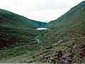
Glen Lui is a beautiful valley, or "glen," located in Aberdeenshire, Scotland. Its name comes from the Scottish Gaelic "Gleann Laoigh," which means "calves' glen." This special place is part of the large Mar Lodge Estate.
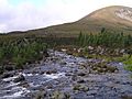
The main river flowing through Glen Lui is called the Lui Water. This river eventually joins the bigger River Dee, about half a mile downstream from a well-known spot called the Linn of Dee.
Contents
The Canadian Campsite: A Wartime Story
Near the start of Glen Lui, there's an area known as the Canadian Campsite. This was a busy lumber camp during World War II. Canadian lumberjacks lived and worked here, helping to cut down trees for the war effort.
The campsite was on the east side of the Lui Water and the north side of the River Dee. It even stretched across the public road. Today, this area is covered by a forest that was planted in the 1980s.
Before the new forest grew, you could still see signs of the old camp. There were concrete blocks on the ground and old logs that were "nailed" together with big metal spikes. Some of the tall Scots pine trees even had old insulators on them, which were probably used for their telephone system.

Near a small beach on the south side of the campsite, a log bridge used to cross the River Dee. You can still see spiked logs on the north bank and spikes in the rocks on the south bank, showing exactly where the bridge once stood. This bridge lasted until the 1960s.
A writer named Fenton Wyness described it:
The bridge built over the River Dee above Inverey by Canadian lumbermen during the Second World War. Damaged by floods, it was eventually demolished.
—Wyness, Fenton
Before the forest was planted, the Canadian Campsite was a popular spot for campers and people with caravans. Many hikers would camp here overnight before heading into the Cairngorms mountains or continuing their journey to Braemar. Some caravan owners even left their caravans there for long periods, creating a friendly community. The Mar Lodge Estate helped manage the area by providing a rubbish pit for waste.
There was also a large, man-made "big ditch" at the Canadian Campsite. It seemed to connect to the Lui Water. This ditch was over 10 feet deep and 20 feet wide at its widest points. Many spiked logs were found along the ditch.
-
The Canadian Campsite showing concrete blocks and rubbish-pit spoil (1970s).
-
The Canadian Campsite showing the 'big ditch' (1970s).
-
The Canadian Campsite after it was fenced off (1980s).
-
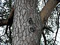
Isolators in a tree.


About 150 yards from where the Lui Water joins the River Dee, a public road crosses the Lui Water at a spot called the Linn of Lui. This road leads towards Mar Lodge and Allanaquoich in one direction, and towards Linn of Dee in the other.
From Linn of Lui to Black Bridge
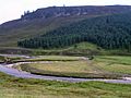
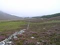
If you follow the public road west from the Linn of Lui for about 100 yards, you'll find a wooden gate. This gate marks the start of a main route that leads north into the Lairig Ghru mountains. You can follow this route up Glen Lui, alongside the Lui Water.
You can also start this route from the Linn of Dee car park. Just follow the signs through the forest. Either way, this road leads to the "Black Bridge." Even though it's now painted red, people still call it the Black Bridge!
Slightly upstream from the bridge, you can still see parts of old "sluices and concrete banks" in the Lui Water. These were built by the Canadians during their time here.
-
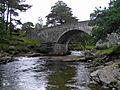
Linn of Lui
-
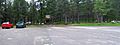
Linn of Dee car park

From Black Bridge to Derry Wood
After crossing the Black Bridge, turn left and follow the road further up Glen Lui towards an area called The Derry.
This part of Glen Lui is a wide valley that was shaped by ancient glaciers. You can see mounds of earth and rocks called moraines, which are left over from the glaciers. You might also spot grassy, rectangular shapes on the ground. These are the remains of old farms and small villages, or "townships."
A writer named Seton Gordon, who wrote about the area in 1925, was sad that many old local names for places were being forgotten. Luckily, he worked hard to record many of these names and other knowledge about the Cairngorms, so they wouldn't be lost forever. For example, he named two moraines in Glen Lui, just upstream from Black Bridge, "Da Shithean," which means "Two Fairy Mounds."
The Black Bridge itself was rebuilt in 1988 by a group from the military.
Clais Fhearniag: A Hollow in the Hills
A little over half a mile past the Black Bridge, just before a stream called Allt a' Mhadaidh, a footpath goes up the hillside. This path leads through a narrow valley called Clais Fhearniag, which means "The Hollow of the Alder." The path through Clais Fhearniag takes you to Glen Quoich.
It's believed that Clais Fhearniag was formed during the Ice Age. Rivers flowing under the melting glaciers carved out these steep, rocky gullies. There's also a man-made dam at the east end of the hollow.
The Old Townships: A Look Back in Time
Before the Jacobite rising in 1715, many people lived in Glen Lui. The valley floor was dotted with farms and small villages. However, after 1724, the new owners of the Mar Lodge Estate decided to remove the farmers from Glen Lui. This happened in 1726.
Historical letters show that the estate owners wanted these people to leave after their harvest was finished. The main reason for this was to make it easier to cut down trees and transport timber from the glen.
It seems the glen was settled again by 1732, but then cleared once more by 1777. By this time, all the farms in Glen Lui were taken back by the landowner, Earl Fife.
Old maps show some of the place names from these early settlements. For example, maps from the 1740s and 1750s show names like Achavadie and Rinton to the north of the Lui Water, and Dalgirmich to the south. Later maps from the 1990s show similar names, like Wester Auchavrie and Easter Auchavrie.
Interestingly, the stream Allt a' Mhadaidh has a special meaning. Some say its full name, Allt a' Mhadaidh Allaidh, means "the Wolf's Burn," remembering the last wolf killed in the Forest of Mar.
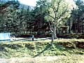
-
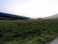
Moraines
-
Cnoc na Teididh
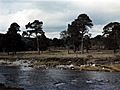
-
Clais Fhearniag (1970s)
-
Easter Auchavrie, and Wester Auchavrie


Derry Wood: A Special Grove
The area known as Derry Wood (or simply 'The Derry') gets its name from the Gaelic "An Doire," meaning "the grove." As you approach Derry Wood from the direction of Linn of Dee, you can see Carn Crom, a part of Derry Cairngorm, rising behind it.
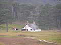
Inside Derry Wood is an old building called Derry Lodge. Some people thought it might have been the Head Keeper's house, but records show that the Head Keeper actually lived elsewhere. Derry Lodge was likely used as a temporary place for hunting parties to stay.
The paths through Derry Wood can be a bit tricky to follow. For example, a road leading southwest towards the Lui Water doesn't have a bridge. Just past Derry Lodge, another road leading southwest to the Derry Burn also doesn't have a bridge anymore. It used to continue over the Luibeg Burn towards Luibeg Cottage, where a famous deer stalker named Bob Scott lived for many years.
To continue your journey, you need to go straight past Derry Lodge, cross the Derry Burn using the footbridge, and then stay close to the north bank of the Luibeg Burn until you find the road again.
On the west side of the Derry Burn, a path leads north up Glen Derry towards Lairig an Laoigh.
-
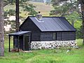
Bob Scott's Bothy (MK3)
-
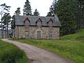
Derry Lodge
-
Luibeg Cottage
-
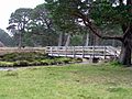
Derry Burn footbridge


From Derry Wood to Glen Dee
Glen Luibeg: A Scenic Route
Glen Luibeg might be considered to start where the Derry Burn joins the Lui Water. From here, the path follows the northern bank of the Luibeg Burn. The main road used to cross a bridge at Derry Lodge, pass Luibeg Cottage, and then cross the Luibeg Burn, leading all the way to a place called Preas nam Meirleach, which means "Robber's Copse." This route has recently been made narrower and is no longer regularly used by vehicles.
Coire Craobh an Oir: The Corrie of Gold
Just west of Luibeg, on the south side of Carn Crom, there's a shallow hollow called Coire Craobh an Oir. This name means "corrie of the tree of gold." There's an old legend connected to this name. It's said that a member of the Mackenzie family, who owned the land where Mar Lodge now stands, once buried treasure from a raid near a tree in this corrie. He later moved it to another spot called Cairn Geldie, where the legend says it remains to this day!
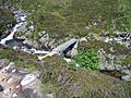
Preas nam Meirleach: The Robber's Copse
At Preas nam Meirleach, the Luibeg Burn crosses the footpath. This means you either have to wade across the burn or take a detour upstream to the Luibeg Bridge. Older maps don't show this detour because an earlier bridge used to be here, but it was destroyed by a flood. You can still see parts of it in the burn.
From Preas nam Meirleach, the path continues around the base of Carn a' Mhaim. It eventually turns north as it gets closer to the junction with the River Dee Route, Corrour Bothy, and the famous Lairig Ghru mountain pass.
-
The Luibeg Burn at the Robber's Copse
-
The footbridge over the Luibeg Burn upstream from the Robber's Copse
-
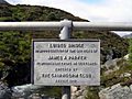
The plaque on the footbridge over the Luibeg Burn
-
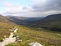
Looking back towards the Robber's Copse and Glen Luibeg


