Càrn a' Mhàim facts for kids
Quick facts for kids Càrn a' Mhàim |
|
|---|---|

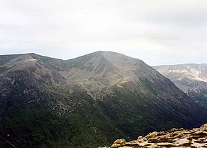
Càrn a' Mhàim from Ben Macdhui.
|
|
| Highest point | |
| Elevation | 1,037 m (3,402 ft) |
| Prominence | c. 231 m |
| Parent peak | Ben Macdui |
| Listing | Munro, Marilyn |
| Naming | |
| English translation | Cairn of the large rounded hill / Hill of the Pass |
| Language of name | Gaelic |
| Geography | |
| Location | Cairngorms, Scotland |
| Parent range | Grampians |
| OS grid | NN994952 |
| Topo map | OS Landranger 43,36 OS Explorers 403 |
Càrn a' Mhàim is a fantastic Scottish mountain. It's located deep within the amazing Cairngorms mountain range. This peak is about 15 kilometers west of Braemar. It sits in the beautiful area of Aberdeenshire.
Contents
Discover Càrn a' Mhàim: A Scottish Mountain
This mountain stands tall at 1037 meters (about 3402 feet). It's part of two long ridges that stretch south from Ben Macdui. Càrn a' Mhàim, along with Ben Macdui and Derry Cairngorm, forms the heart of the Cairngorms. These mountains are found between two big mountain passes: the Lairig Ghru and the Lairig an Laoigh.
What Does the Name Mean?
The name Càrn a' Mhàim comes from Gaelic. It means "Cairn of the large rounded hill." A cairn is a pile of stones. If you look at the mountain from the south, it does seem rounded. However, it's actually a long ridge running north to south. Another possible meaning is "Hill of the Pass." This makes sense because the mountain is right at the entrance to the Lairig Ghru pass.
Unique Ridge Walk in the Cairngorms
Càrn a' Mhàim is special because it has the only significant ridge walk in the entire Cairngorms range. This means you can walk along a narrow, high path with great views on both sides.
Exploring Càrn a' Mhàim's Slopes
Càrn a' Mhàim's sides drop steeply from its top in three directions. The western slopes fall sharply towards the Lairig Ghru pass. The eastern slopes go down more gently to the Luibeg Burn valley. To the southeast, there's a wide ridge that ends in the rocky cliffs of Coire na Poite.
The Northern Ridge to Ben Macdui
To the north, a narrow ridge stretches for two kilometers. This is often called the only truly notable ridge in the Cairngorms. It connects Càrn a' Mhàim to the much larger Ben Macdui. Walking this ridge is a challenging but rewarding journey. It offers amazing views of nearby peaks like The Devil's Point and Cairn Toul.
The path drops down to a low point, called a col, between the two mountains. This col is about 800 meters high. From there, it's a tough climb of 500 meters up the side of the Allt Clach nan Tàillear. This climb involves a lot of stepping over large rocks, or "boulder-hopping," to reach Ben Macdui's flat summit area.
How to Climb Càrn a' Mhàim
Most people start their climb of Càrn a' Mhàim from the Linn of Dee car park (NO065901). From there, you follow a track that leads to Derry Lodge. You can even ride a bicycle for this part of the journey.
The Path to the Summit
After Derry Lodge, you continue on the path for another 2.5 kilometers. You'll reach a small group of trees called Robbers Copse at the start of Glen Luibeg. From this point, you begin to climb the steep southern slope of Càrn a' Mhàim to reach the top.
Views from the Top
Once you reach the summit of Càrn a' Mhàim, you'll be rewarded with amazing views. You can see the impressive hills that make up the very heart of the Cairngorms. It's a truly memorable sight!

 | Claudette Colvin |
 | Myrlie Evers-Williams |
 | Alberta Odell Jones |

