Glorieta, New Mexico facts for kids
Quick facts for kids
Glorieta, New Mexico
|
|
|---|---|

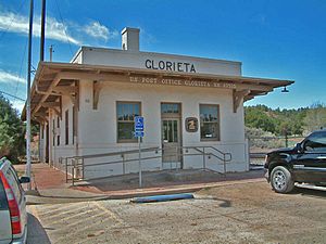
Glorieta's former Santa Fe depot, now a post office.
|
|

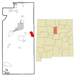
Location of Glorieta, New Mexico
|
|
| Country | United States |
| State | New Mexico |
| County | Santa Fe |
| Area | |
| • Total | 7.65 sq mi (19.81 km2) |
| • Land | 7.65 sq mi (19.81 km2) |
| • Water | 0.00 sq mi (0.00 km2) |
| Elevation | 7,412 ft (2,259 m) |
| Population
(2020)
|
|
| • Total | 511 |
| • Density | 66.81/sq mi (25.79/km2) |
| Time zone | UTC-7 (Mountain (MST)) |
| • Summer (DST) | UTC-6 (MDT) |
| ZIP code |
87535
|
| Area code(s) | 505 |
| FIPS code | 35-29860 |
| GNIS feature ID | 2408302 |
Glorieta is a small community in Santa Fe County, New Mexico, United States. It is known as a census-designated place (CDP). In 2020, about 511 people lived there.
Glorieta is nestled in the southern Sangre de Cristo Mountains. It is located along Interstate 25 and the famous Glorieta Pass.
Contents
History of Glorieta
Glorieta is a place with an important past. Two major battles in New Mexico's history happened here. These were the Capture of Santa Fe and the Battle of Glorieta Pass.
The Battle of Glorieta Pass
The Battle of Glorieta Pass took place in March 1862. This was during the American Civil War. It was a fight between soldiers from the Union and the Confederacy.
The battle was fought for control of the New Mexico Territory. The Union victory helped stop the Confederacy from taking over the American Southwest. This battle is sometimes called the "Gettysburg of the West."
Geography and Location
Glorieta is located in a beautiful area of New Mexico. It is part of the Sangre de Cristo Mountains. The community is also near the Atchison, Topeka and Santa Fe Railway. This railway was once a very important train route.
The total area of Glorieta is about 19.81 square kilometers (7.65 square miles). All of this area is land, with no large bodies of water.
Population and People
Glorieta is a small community. In 2020, the population was 511 people.
Population Changes Over Time
The number of people living in Glorieta has changed over the years.
| Historical population | |||
|---|---|---|---|
| Census | Pop. | %± | |
| 2020 | 511 | — | |
| U.S. Decennial Census | |||
Education in Glorieta
Students in Glorieta attend schools that are part of Santa Fe Public Schools.
Younger students, from kindergarten to 8th grade, go to El Dorado Community School. This school is located in El Dorado. For high school, students attend Santa Fe High School.
See also
 In Spanish: Glorieta (Nuevo México) para niños
 | Anna J. Cooper |
 | Mary McLeod Bethune |
 | Lillie Mae Bradford |


