Goat Hill (Larimer County, Colorado) facts for kids
Quick facts for kids Goat Hill |
|
|---|---|
| Bellvue Dome | |

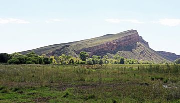
The dome as seen from the north northwest.
|
|
| Highest point | |
| Elevation | 1,708 m (5,604 ft) |
| Geography | |
| Location | Larimer County, Colorado |
| Parent range | Front Range |
| Topo map | USGS Laporte |
Goat Hill, also known as Bellvue Dome, is a unique dome-shaped hill located in Larimer County, Colorado. It stands near the town of Bellvue. This interesting landform is part of the Front Range of the Rocky Mountains.
Goat Hill looks different depending on which side you see. Its east side has a gentle slope, making it look like a regular hill. However, the west side is a very steep cliff. This cliff hangs directly over the Cache la Poudre River, which flows right below it. Geologists believe the mountain formed when soft sedimentary rock was pushed up and folded. This happened during a major mountain-building event called the Laramide orogeny.
Visiting Goat Hill
It can be tricky to get close to Goat Hill. The mountain itself is on land managed by the Bureau of Land Management (BLM). This is a government agency that oversees public lands. However, private properties surround the BLM land. This means you usually need permission from the landowners to cross their property and reach the hill.
Viewing from the Highway
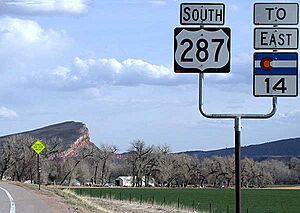
Even if you cannot visit Goat Hill directly, you can still see it clearly. Many people driving south on Highway 287 get a great view. As you drive, you can see the mountain's distinct shape. The gentle slope is on the left, and the dramatic cliff is on the right. This view appears just before the highway turns east towards Fort Collins.
 | Jessica Watkins |
 | Robert Henry Lawrence Jr. |
 | Mae Jemison |
 | Sian Proctor |
 | Guion Bluford |


