Bellvue, Colorado facts for kids
Quick facts for kids
Bellvue, Colorado
|
|
|---|---|
 |
|
| Country | |
| State | |
| County | Larimer County |
| Elevation | 5,134 ft (1,565 m) |
| Time zone | UTC-7 (MST) |
| • Summer (DST) | UTC-6 (MDT) |
| ZIP Code |
80512
|
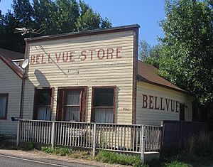
Bellvue is a small community in Larimer County, Colorado. It's not officially a city, but it has its own Post Office. Bellvue is found in a beautiful, narrow area called Pleasant Valley. This valley is located northwest of Fort Collins. It sits right near the entrance of the Poudre Canyon, between a ridge called the Dakota Hogback and the Rocky Mountains. The ZIP Code for the Bellvue Post Office is 80512.
Contents
Discovering Bellvue's Location
Bellvue is a green and lively area. It is on the south side of the Cache la Poudre River. This spot is also at the beginning of Rist Canyon. The Bellvue Dome, also known as "Goat Hill", hides the community. This dome keeps Bellvue separate from the open plains near Fort Collins.
Farming and Wildlife in the Valley
The valley used to stretch south towards the foothills. This area is now covered by Horsetooth Reservoir. Today, farmers in the valley grow hay and other crops. They also raise cattle and horses on ranches. The Colorado Division of Wildlife has a large trout fish farm here. It is just north of the Bellvue community.
A Look Back at Bellvue's History
People have lived near Bellvue for a very long time. Paleoindian sites nearby show human life from over 10,000 years ago. One site is a large bison kill area along the Poudre River.
Early Native American Life
In the early 1800s, Arapaho groups lived in the area. They often had small fights with the Ute tribe. The Ute people lived in the mountains nearby. You can still find old teepee rings in the surrounding foothills. These rings show where their homes once stood.
First Settlers Arrive
The first white settlers came to the valley after 1858. That year, Antoine Janis became the first white settler in northern Colorado. Over the next two years, people started claiming farm and pasture lands. G.R. Sanderson was one of these first settlers. He built the first irrigation ditch in the county in June 1860. This was the second ditch built in northern Colorado. Sanderson sold his land to J.H. Yeager in 1864. The ditch then became known as the Yeager ditch.
More Early Residents
Samuel Bingham was another early settler. He moved to the west side of Bingham Hill in 1860. In the same year, Abner Loomis settled on a ranch in the valley. Loomis was also an important person in Fort Collins. Other early settlers in the 1860s included Benjamin T. Whedbee and Perry J. Bosworth. C.W. Harrington and Louis Blackstock also settled here.
Founding of the Town
In 1873, Jacob Flowers came to the valley. He bought land from Joseph Mason and started a homestead. Flowers had moved west after the Civil War. He lived in Greeley for a short time in 1872. The next year, Flowers followed the Poudre River upstream. He then founded the town of "Bellevue" (the name was later shortened to Bellvue).
The General Store and Post Office
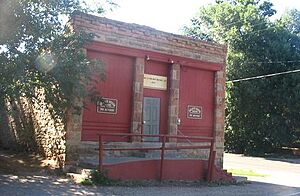
The Union Pacific Railroad was interested in the area. This was because of the many stone quarries near the town of Stout. (Stout is now covered by Horsetooth Reservoir.) Many railroad workers came to work in the quarries. This led Jacob Flowers to open a general store, a saloon, and a barber shop. He also opened a post office. In 1880, he built a one-story sandstone building for his businesses.
The Bellvue Post Office opened in this building on June 24, 1884. The building served as the local general store and post office for many years. Later, it became the meeting place for Cache la Poudre Grange, Chapter 456. This is a local chapter of the grange, a community organization.
Community Fun and Events
Jacob Flowers also built a track and a bandstand south of town. These were used for horse racing and community celebrations. Traveling medicine shows and dog and pony shows also came to perform there.
Bellvue's Location on the Map
Bellvue is located at 40°37′32″N 105°10′16″W / 40.62556°N 105.17111°W. This shows its exact spot on a map.
Images for kids
 | John T. Biggers |
 | Thomas Blackshear |
 | Mark Bradford |
 | Beverly Buchanan |


