
Goeree-Overflakkee facts for kids
Quick facts for kids
Goeree-Overflakkee
|
|||
|---|---|---|---|
|
Island and Municipality
|
|||

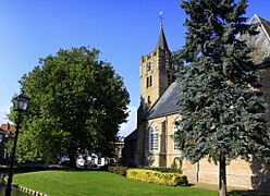
View over Goedereede
|
|||
|
|||
.svg)
Location in South Holland
|
|||
| Country | Netherlands | ||
| Province | South Holland | ||
| Established | 1 January 2013 | ||
| Government | |||
| • Body | Municipal council | ||
| Area | |||
| • Total | 422.34 km2 (163.07 sq mi) | ||
| • Land | 262.00 km2 (101.16 sq mi) | ||
| • Water | 160.34 km2 (61.91 sq mi) | ||
| Elevation | 1 m (3 ft) | ||
| Population
(May 2014)
|
|||
| • Total | 48,204 | ||
| • Density | 184/km2 (480/sq mi) | ||
| Time zone | UTC+1 (CET) | ||
| • Summer (DST) | UTC+2 (CEST) | ||
| Postcode |
3240–3258
|
||
| Area code | 0187 | ||


Goeree-Overflakkee (pronounced goo-RAY-oh-ver-FLAH-kay) is an island in the Netherlands. It is the southernmost island in the South Holland province. This island is surrounded by water, with the Haringvliet to the north, the Volkerak to the east, and Lake Grevelingen to the south.
Since 2013, Goeree-Overflakkee has also been a single municipality. This means it is a local government area. It was formed by joining four smaller municipalities: Goedereede, Dirksland, Middelharnis, and Oostflakkee. The biggest towns on the island are Sommelsdijk, Middelharnis, Ouddorp, and Dirksland. Even though it's in South Holland, the island's look and local language are more like Zeeland. People here speak special dialects called Goereês and Flakkees.
Contents
History of the Island
Goeree-Overflakkee became an island because of big floods. The first major flood happened in 1216. This flood broke through the sand dunes of Voorne-Putten and created a deep saltwater channel.
Later, in the St. Elizabeth floods of 1421, this channel connected to the Merwede river. It then became an important mouth for the Rhine and Meuse rivers. This is how the island was separated from the mainland.
Exploring the Former Municipalities
Before 2013, Goeree-Overflakkee was made up of four smaller municipalities. Each had its own unique towns and features.
Goedereede: Where Tourism Meets Fishing

The former municipality of Goedereede is on the western side of the island. It includes towns like Ouddorp, Goedereede, and Stellendam. Most of its money comes from tourism and fishing.
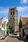
Ouddorp is a popular spot for tourists. It has a long beach and many camping sites. Both Goedereede and Stellendam have large fishing fleets. The town of Goedereede has many old buildings and a tall church tower. It is one of only two towns on the island that were granted city rights a long time ago.
Stellendam was badly affected by the North Sea flood of 1953. Several monuments in the town remember this sad event. Near Stellendam is the Haringvlietdam. This dam protects the Haringvliet from the North Sea and is part of the Delta Project. You can learn about the dam at the 'Delta Expo' nearby.
Dirksland: Home to the Hospital and Windmills

The former municipality of Dirksland included the towns of Melissant, Herkingen, and Dirksland. These areas were not as affected by the 1953 flood because they are on higher ground. Dirksland was the largest of these three towns. It has the only hospital on the island, called Van Weel-Bethesda. This hospital is known for its excellent care.
Dirksland is easy to spot from far away because of its very tall water tower. The towns in this area focus on farming. They also have several camping sites. Dirksland has an inland harbor with a recently fixed gate system.
Herkingen is on the south side of the island, next to the Grevelingenmeer. This is a saltwater lake. It is a popular place for water sports. Herkingen has a large yachting harbor and is growing its tourism industry. You can also see some of the country's biggest modern windmills near Herkingen.
Middelharnis: The Island's Lively Center

The former municipality of Middelharnis was in the middle of the island. It was the biggest of the four, with over 17,000 people. It included towns like Sommelsdijk, Middelharnis, Nieuwe-Tonge, and Stad aan 't Haringvliet.
Middelharnis has a shopping area called D'n Diek. This shopping area is on a dike that used to protect the towns from the Haringvliet. On Fridays in the summer, they have "Diekdagen" (Dike days) with special activities. The town has both a public and a Christian high school. Middelharnis also has an inland harbor connected to the Haringvliet.
In Sommelsdijk, you'll find a sports complex with a swimming pool called De Staver. Stad aan 't Haringvliet has a small harbor and a beach. Like many towns on the island, it has a preserved old windmill. Nieuwe-Tonge's main roads are two dikes that form the town's edges.
Oostflakkee: Eastern Charm and a Long Walk

The former municipality of Oostflakkee is on the eastern side of the island. It includes towns such as Den Bommel, Oude-Tonge, Ooltgensplaat, Achthuizen, and Langstraat.
Oude-Tonge was the main town of this area. It has a notable industrial zone and a large bus station. Oude-Tonge was hit hardest by the 1953 flood. The queen visited in 2003 to remember the 50th anniversary of this event.
Den Bommel has a harbor and a beach on the shores of the Haringvliet. A few kilometers east is Zuidzijde, a very small town. Ooltgensplaat is the most eastern town on the island. It has a harbor on the Volkerak. This town has a very old municipal building. Ooltgensplaat is also the start and finish point for "De Omloop." This is an annual walk of over 100 km around the island, completed within 24 hours. It happens in late August and brings in thousands of people. Achthuizen and Langstraat are other small towns near Ooltgensplaat.
Famous People from Goeree-Overflakkee

Many interesting people have come from Goeree-Overflakkee:
- Jan van Os (1744 in Middelharnis – 1808) was a Dutch painter.
- Laurens J. Bol (1898 in Ooltgensplaat – 1994) was an art historian who studied Dutch Golden Age painters.
- Aart Alblas (1918 in Middelharnis – 1944) was a brave Dutch resistance member during World War II.
- Tomas Ross (born 1944 in Den Bommel) is a Dutch writer known for historical thrillers.
- Elco Brinkman (born 1948 in Dirksland) was a Dutch politician and businessman.
- Toine van Peperstraten (born 1967 in Achthuizen) is a Dutch sports journalist.
- Barbara Baarsma (born 1969) is a Dutch economist who grew up on the island.
- Liesbeth Zegveld (born 1970) is a Dutch lawyer and professor.
Sporting Heroes
- Jan Pieterse (born 1942 in Oude-Tonge) was a professional cyclist. He won a gold medal in the 1964 Summer Olympics.
- Arie Luyendyk (born 1953 in Sommelsdijk) is a Dutch former race car driver. He won the famous Indianapolis 500 race twice.
- Juliette Bergmann (born 1958 in Vlaardingen) is a Dutch female bodybuilding champion.
- Annemarieke van Rumpt (born 1980 in Middelharnis) is a rower. She won a bronze medal at the 2004 Summer Olympics.
Gorée Island in Senegal
The island of Gorée in Senegal, West Africa, got its name from the Dutch island of Goeree. In the 18th century, Gorée was a sad center for the slave trade. The Netherlands ruled Gorée from 1588 to 1664.
Gallery
-
Reformed Church at Nieuwe-Tonge
-
Lighthouse at Goedereede
-
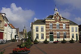
Quay in Oude-Tonge
-
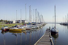
Port at Herkingen


See also
 In Spanish: Goeree-Overflakkee para niños
