Goose Gap facts for kids
Quick facts for kids Goose Gap |
|
|---|---|

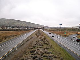
Interstate 182 approaching Goose Gap.
|
|
| Elevation | 860 ft (262 m) |
| Traversed by | |
| Location | Benton County, Washington |
| Range | Yakima Fold Belt |
| Coordinates | 46°14′42″N 119°21′26″W / 46.24500°N 119.35722°W |
Goose Gap is a low area, like a small valley, between two hills called Badger Mountain and Candy Mountain. It's located west of Richland, Washington, in a region known as the Tri-Cities. This gap is an important pathway, especially for cars, as a major highway called Interstate 182 crosses right through it.
Contents
What is Goose Gap?
Goose Gap is a natural opening in the land. It connects different areas and makes travel easier. Think of it like a natural bridge between two higher points. The gap sits higher than most of the surrounding Tri-Cities area. This makes it a key spot for transportation.
How High is Goose Gap?
Goose Gap reaches an elevation of about 860 feet (262 meters) above sea level. This height allows it to connect the two mountains while still being a manageable route for roads.
Busy Travel Route
Many people use Goose Gap every day. On average, about 18,000 vehicles travel through this gap daily. This shows how important it is for connecting communities and helping people get around the region.
Life Around the Gap
The land around Goose Gap changes depending on which side you are on. To the east of Interstate 182, you'll find homes and neighborhoods. This means people live quite close to this busy travel route.
Farming and Nature
However, if you look to the west of the highway, the scenery changes. Here, you'll mostly see farms and agricultural land. This area is used for growing crops. The mix of homes and farms shows how different types of land use exist side-by-side near Goose Gap.
Future Hiking Trails
There are plans to make Goose Gap even more useful for outdoor activities. A group called Friends of Badger Mountain is working on a new hiking trail. This trail will connect Badger Mountain to Candy Mountain. It will cross Goose Gap, running in a north-to-south direction. This means it will go across the Interstate, offering new ways for people to explore the area on foot.
 | Selma Burke |
 | Pauline Powell Burns |
 | Frederick J. Brown |
 | Robert Blackburn |

