
Badger Mountain (Benton County, Washington) facts for kids
Quick facts for kids Badger Mountain |
|
|---|---|

Badger Mountain from the Richland Y.
|
|
| Highest point | |
| Elevation | 1,593 ft (486 m) NAVD 88 |
| Prominence | 915 ft (279 m) |
| Isolation | 8.44 mi (13.58 km) |
| Geography | |

Badger Mountain
Location in Washington (state)
|
|
| Parent range | Columbia River Plateau |
| Topo map | USGS Badger Mountain |
| Climbing | |
| Easiest route | Hike |
Badger Mountain is a small but popular mountain located in Richland, Washington. It rises above the Tri-Cities area. Badger Mountain is connected to the smaller Candy Mountain by a place called Goose Gap. You can see Badger Mountain from many parts of the area. It is a very popular spot for hiking for people of all skill levels.
Most of Badger Mountain is protected. It is part of the Badger Mountain Centennial Preserve. However, the radio towers at the very top are private property. Badger Mountain has two main peaks, known as the East Summit and the West Summit. The West Summit is the highest point on the mountain.
Contents
How Badger Mountain Formed
Badger Mountain is part of something called the Yakima Fold Belt. Imagine the Earth's crust as a rug. When you push the rug from the sides, it creates wrinkles or folds. That's how the Yakima Fold Belt formed, from slow pushes in the Earth. This folded area stretches from near Vantage, Washington to the Columbia River.
The mountain is also made of basalt rock. This rock came from huge lava flows many millions of years ago. About 10 to 15 million years ago, lava poured out from the Yellowstone hotspot. At that time, the hotspot was located in western Idaho. These lava flows covered large parts of Washington and Oregon. In some places, the basalt rock is over 5,900 feet (1,800 meters) thick!
When Ice and Water Shaped the Mountain
During the last ice age, huge glaciers covered parts of northern Washington. These glaciers blocked the Clark Fork River. This created a massive lake called Glacial Lake Missoula. From time to time, the ice dam holding back the lake would break. This caused enormous floods, known as the Missoula Floods.
These floods rushed towards the Pacific Ocean. They carried large rocks called glacial erratics. These rocks are usually found in different places, like granite from the mountains. The floodwaters around Badger Mountain reached about 1,250 feet (381 meters) above sea level. This meant Badger Mountain became a temporary island during the floods. You can still see these unique rocks on the mountain today. There's even a marker on the Canyon Trail at the 1,250-foot elevation.
Fun Things to Do: Hiking and Views

Badger Mountain is a popular place for outdoor activities. Many people come here for hiking and to take amazing photos. Because the mountain is high above the Tri-Cities, it offers incredible views. On a clear day, you can see far-off mountains. These include Rattlesnake Mountain and the Blue Mountains. You can also spot major Cascade Mountains peaks. These include Mount Hood, Mount Adams, Mount Rainier, and Mount Stuart.
There are two main parking areas for the mountain. One is at Trailhead Park on the northeast side. The other is off Dallas Road on the west side. In 2010, more than 71,000 people visited Badger Mountain!
Exploring the Trails
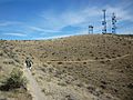
There are several trails on Badger Mountain for different activities. Two trails go all the way to the top of the mountain: the Canyon Trail and the Skyline Trail.
- The Canyon Trail is about 1.3 miles (2.1 km) long. It starts at Trailhead Park. This trail is only for hikers.
- The Skyline Trail is longer, about 2.9 miles (4.7 km). It starts off Dallas Road on the northwest side. This trail follows the ridge of Badger Mountain. You can hike, mountain bike, or ride horses on the Skyline Trail.
Other trails explore the slopes of the mountain but do not reach the peak:
- The Sagebrush Trail connects the Skyline Trail to Trailhead Park.
- The Langdon Trail goes around the south side of the mountain. It offers great views of Badger Canyon and the Horse Heaven Hills. Hikers, mountain bikers, and horseback riders can use this trail.
- The Badger Flats Trail is entirely within Trailhead Park. It is about 0.6 miles (1 km) long.
Weather and Animals
Badger Mountain is located in a "rain shadow." This means the Cascade Mountains block most of the rain. Because of this, the area has a dry climate. Winters are mild, and summers are very hot. The nearby airport gets about 7.94 inches (202 mm) of rain each year. Temperatures often go above 100°F (38°C) in the summer.
Because of the dry climate, Badger Mountain has wildlife similar to the surrounding desert-like areas. You might see plants like sagebrush. Animals like jackrabbits and rattlesnakes also live here. There are no natural trees growing on the mountain.
Snow can fall in winter. If you plan to visit during snowy periods, be sure to prepare for the weather.
Images for kids
-
Hiking trail near summit

