Gosnell, Arkansas facts for kids
Quick facts for kids
Gosnell, Arkansas
|
|
|---|---|

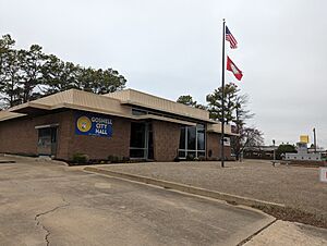
Gosnell City Hall
|
|
| Motto(s):
Moving Forward, Moving Strong
|
|

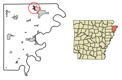
Location in Mississippi County, Arkansas
|
|
| Country | United States |
| State | Arkansas |
| County | Mississippi |
| Incorporated | March 12, 1968 |
| Named for | Lemuel Ward Gosnell (1854-1926) |
| Area | |
| • Total | 1.61 sq mi (4.18 km2) |
| • Land | 1.61 sq mi (4.18 km2) |
| • Water | 0.00 sq mi (0.00 km2) |
| Elevation | 243 ft (74 m) |
| Population
(2020)
|
|
| • Total | 2,910 |
| • Density | 1,801.86/sq mi (695.84/km2) |
| Time zone | UTC-6 (Central (CST)) |
| • Summer (DST) | UTC-5 (CDT) |
| ZIP codes |
72315, 72319
|
| Area code(s) | 870 |
| FIPS code | 05-27700 |
| GNIS feature ID | 2403717 |
Gosnell is a small city located in the northern part of Mississippi County, in the state of Arkansas, United States. In 2020, about 2,910 people lived there. This was a decrease from the 3,548 people counted in 2010.
Contents
A Look Back: Gosnell's History
How Gosnell Got Its Name
Back in the 1870s, a cemetery called North Sawba was created in the area. Later, a lot of land between Blytheville and Big Lake was bought by Lemael W. Gosnell. He was a dentist and a farmer who helped settle the area. Over time, the community was named after him.
L.W. Gosnell came from Tennessee to Mississippi County in 1876. He first worked as a store clerk in nearby towns. Later, he became a partner in a general store in Blytheville.
Early Growth and Changes
Before 1903, the small community of Gosnell got its first railroad service. This happened when the Paragould and Southeastern Railroad extended its line. This new line connected Hornersville, Missouri, to Chickasawba, Arkansas.
By the mid-1920s, Gosnell had its own one-room schoolhouse. A superintendent named C.F. Cooper helped the school grow. By the time he retired in 1930, a high school program had been added. During the big 1937 flood, Gosnell helped about 300 people who lost their homes. Many wild animals also fled to the area after the Mississippi River flooded.
The Air Force Base Era
In 1942, the U.S. Army looked for land in Mississippi County to build a pilot training school. By April of that year, they told 62 landowners in Gosnell that their land was needed. By June, the Blytheville Army Airfield was open. It was a training center for B-25 bomber pilots.
The school closed in 1946 and became a neighborhood. But in 1954, it reopened as Blytheville Air Force Base. It was a base for B-57 and later B-52 planes.
Becoming an Official City
Gosnell officially became a city on March 12, 1968. Andy Bevill was the first mayor of Gosnell after it became a city.
Where is Gosnell?
Gosnell is located in a flat area of Arkansas called the Arkansas Delta. It's in the northern part of Mississippi County. The city of Blytheville, which is the county seat, is right next to Gosnell on its east side. The state line of Missouri is less than 3 miles (4.8 km) to the north.
According to the United States Census Bureau, Gosnell covers about 1.6 square miles (4.1 square kilometers) of land. There is no water within the city limits.
Natural Surroundings
Gosnell is in an area known as the St. Francis Lowlands. This area is mostly flat and used for farming today. It also has unique features like sand blows and sunken lands. These were formed by the powerful 1811–12 New Madrid earthquakes. Many waterways in the area have been straightened, which has changed the homes for water animals and plants along the rivers.
The Big Lake National Wildlife Refuge is about 6 miles (9.7 km) west of Gosnell. This refuge protects some of the original forests that used to cover this region before farms were built.
Exploring Gosnell's Landmarks
If you leave Blytheville on Chickasawba Street and travel about 1.3 miles (2.1 km) on Gosnell Road, you will find the famous Chickasawba Indian Mound. This mound is about 25 feet (7.6 meters) tall. Its base is about 130 feet (40 meters) around. It was likely used as a signal or a special temple mound. No ancient pottery or bones have been found there.
People of Gosnell
| Historical population | |||
|---|---|---|---|
| Census | Pop. | %± | |
| 1970 | 1,386 | — | |
| 1980 | 3,215 | 132.0% | |
| 1990 | 3,783 | 17.7% | |
| 2000 | 3,968 | 4.9% | |
| 2010 | 3,548 | −10.6% | |
| 2020 | 2,910 | −18.0% | |
| U.S. Decennial Census 2014 Estimate |
|||
What the 2010 Census Showed
In 2010, there were 3,548 people living in Gosnell. These people lived in 1,387 homes. About 951 of these were families.
Most of the people in Gosnell were White (72.9%). About 22.0% were Black or African American. Other groups included Native American (0.4%), Asian (1.0%), and people from other races (1.6%). About 2.1% of people were of two or more races. People of Hispanic or Latino background made up 3.5% of the population.
In the homes, 48.1% had children under 18 living there. About 45.9% were married couples. Some homes had a female head of household without a husband (23.2%). Others had a male head of household without a wife (7.8%). About 23.2% were not families.
The average income for a household in Gosnell was $43,722. For families, the average income was $46,389. The average income per person in the city was $15,917.
Gosnell's Economy and Schools
Gosnell's economy used to rely a lot on the nearby Blytheville/Eaker Air Force Base. However, after the base closed in the early 1990s, many people moved away from the city.
Today, the city is home to the Gosnell School District. In 2011, this district had about 1,438 students from kindergarten through 12th grade.
Fun Events in Gosnell
Gosnell has an exciting event each year! The city holds its Annual Cotton Festival in October. It's a great way to celebrate the local history and culture.
Education in Gosnell
Students in Gosnell can attend public schools within the Gosnell School District. This district provides education for elementary and secondary school students. Students can graduate from Gosnell High School. The school's mascot and athletic team name is the Pirate. Their school colors are blue and gold.
Weather in Gosnell
Gosnell has a humid subtropical climate. This means it has hot, humid summers and mild winters.
| Climate data for Gosnell, Arkansas | |||||||||||||
|---|---|---|---|---|---|---|---|---|---|---|---|---|---|
| Month | Jan | Feb | Mar | Apr | May | Jun | Jul | Aug | Sep | Oct | Nov | Dec | Year |
| Mean daily maximum °F (°C) | 45 (7) |
50 (10) |
59 (15) |
70 (21) |
79 (26) |
88 (31) |
90 (32) |
90 (32) |
83 (28) |
72 (22) |
60 (16) |
48 (9) |
70 (21) |
| Mean daily minimum °F (°C) | 29 (−2) |
33 (1) |
41 (5) |
51 (11) |
61 (16) |
69 (21) |
72 (22) |
71 (22) |
63 (17) |
51 (11) |
42 (6) |
32 (0) |
51 (11) |
| Average precipitation inches (mm) | 3.67 (93) |
4.31 (109) |
4.54 (115) |
4.91 (125) |
5.23 (133) |
3.90 (99) |
4.02 (102) |
2.61 (66) |
2.88 (73) |
4.08 (104) |
4.70 (119) |
5.07 (129) |
49.92 (1,268) |
Natural Events in Gosnell
Tornado Activity
The Gosnell area experiences more tornadoes than the average for Arkansas. It has 220% more tornado activity than the overall U.S. average.
On May 15, 1968, a very strong F4 tornado hit about 5.6 miles (9.0 km) from Gosnell. This tornado had wind speeds between 207 and 260 miles per hour. It caused a lot of damage and sadly, 35 people lost their lives. Another 364 people were injured.
Later, on April 16, 1998, another F4 tornado struck about 10.1 miles (16.3 km) from the city. This tornado caused two deaths and injured twelve people.
Earthquake Activity
The Gosnell area also has more earthquake activity than the average for Arkansas. It is 91% greater than the overall U.S. average.
Here are some notable earthquakes that have occurred near Gosnell:
- On March 25, 1976, a magnitude 5.0 earthquake happened about 30.3 miles (48.8 km) away.
- On May 4, 1991, another magnitude 5.0 earthquake occurred about 42.3 miles (68.1 km) away.
- On April 27, 1989, a magnitude 4.7 earthquake was recorded 11.5 miles (18.5 km) from the city center.
- On November 29, 1996, a magnitude 4.3 earthquake happened very close, about 3.8 miles (6.1 km) away from Gosnell.
Other Natural Disasters
Mississippi County, where Gosnell is located, experiences a similar number of natural disasters as the U.S. average. The most common types of disasters include storms, floods, tornadoes, and winter storms.
See also
 In Spanish: Gosnell para niños
 | Shirley Ann Jackson |
 | Garett Morgan |
 | J. Ernest Wilkins Jr. |
 | Elijah McCoy |

