Grant, Alabama facts for kids
Quick facts for kids
Grant, Alabama
|
||
|---|---|---|

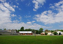
Buildings on Main Street
|
||
|
||
| Nickname(s):
"Home of the DAR Patriots"
|
||
| Motto(s):
"...a scenic mountain town"
|
||

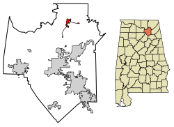
Location in Marshall County, Alabama
|
||
| Country | United States | |
| State | Alabama | |
| County | Marshall | |
| Area | ||
| • Total | 1.85 sq mi (4.81 km2) | |
| • Land | 1.85 sq mi (4.80 km2) | |
| • Water | 0.00 sq mi (0.01 km2) | |
| Elevation | 1,250 ft (380 m) | |
| Population
(2020)
|
||
| • Total | 1,039 | |
| • Density | 561.32/sq mi (216.68/km2) | |
| Time zone | UTC-6 (Central (CST)) | |
| • Summer (DST) | UTC-5 (CDT) | |
| ZIP code |
35747
|
|
| Area code(s) | 256 | |
| FIPS code | 01-31096 | |
| GNIS feature ID | 2406603 | |
Grant is a town located in Marshall County, Alabama, United States. In the 2020 census, the town had a population of 1,039 people. This was an increase from 896 people counted in the 2010 census. Grant is part of the larger Huntsville-Decatur Combined Statistical Area. The town officially became a town on November 15, 1945, with Delbert Hodges serving as its first mayor.
Contents
History of Grant
Grant was first settled in the late 1830s. A post office was opened there in 1887. The town was named after General Ulysses S. Grant. This was because many people in the area had supported the Union during the American Civil War, even though Alabama was a Confederate state.
In 1924, a group called the Daughters of the American Revolution (DAR) started the Kate Duncan Smith DAR School in Grant. They did this to help build schools in places that didn't have good public education. This school is now listed on the National Register of Historic Places. It still teaches students from kindergarten through 12th grade. It is also the only K-12 school owned and run by the DAR.
Geography and Nature
Grant is located in the northeastern part of Marshall County. It sits at an elevation of about 1,240 feet (380 m) on the flat top of Gunters Mountain. The town is mainly found along County Road 5, which is also called Cathedral Caverns Highway and Main Street in Grant. This road is near the northern edge of Gunters Mountain.
However, the town also includes areas stretching south along County Road 5 across the mountain to the edge of Guntersville Lake. It also goes east along Baker Mountain Road to the mountain's edge. Grant is about 13 miles (21 km) north of Guntersville, 18 miles (29 km) southwest of Scottsboro, and 30 miles (48 km) southeast of Huntsville.
The U.S. Census Bureau states that the town of Grant covers a total area of about 1.9 square miles (4.9 km2). A very small part of this area, about 0.22%, is water. A famous cave called Cathedral Caverns is located about 5 miles (8 km) north of Grant, close to Kennamer Cove.
Population Information
| Historical population | |||
|---|---|---|---|
| Census | Pop. | %± | |
| 1950 | 191 | — | |
| 1960 | 274 | 43.5% | |
| 1970 | 382 | 39.4% | |
| 1980 | 632 | 65.4% | |
| 1990 | 638 | 0.9% | |
| 2000 | 665 | 4.2% | |
| 2010 | 896 | 34.7% | |
| 2020 | 1,039 | 16.0% | |
| U.S. Decennial Census 2013 Estimate |
|||
2020 Census Details
The 2020 United States census counted 1,039 people living in Grant. There were 375 households, which are groups of people living together in one home. Out of these, 286 were families.
The table below shows the different racial groups that make up the population of Grant:
| Race | Number of People | Percentage |
|---|---|---|
| White (not Hispanic or Latino) | 975 | 93.84% |
| Black or African American (not Hispanic or Latino) | 4 | 0.38% |
| Native American | 10 | 0.96% |
| Asian | 2 | 0.19% |
| Other/Mixed (two or more races) | 33 | 3.18% |
| Hispanic or Latino | 15 | 1.44% |
Famous People from Grant
- Vernon Derrick was a talented fiddle and mandolin player. He was part of Hank Williams Jr's band, The Bama Band, in the 1980s.
See also
 In Spanish: Grant (Alabama) para niños
 | Charles R. Drew |
 | Benjamin Banneker |
 | Jane C. Wright |
 | Roger Arliner Young |


