
Graveyard Fields facts for kids
Quick facts for kids Graveyard Fields |
|
|---|---|

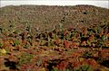
View NW from the parking area off the Blue Ridge Parkway.
|
|
| Location | Pisgah National Forest, Transylvania County, North Carolina |
| Coordinates | 35°19′17″N 82°50′58″W / 35.32147°N 82.84949°W |
| Elevation | 1,530 metres (5,020 ft) |
| Topo map | Shining Rock, NC |
Graveyard Fields is a special and beautiful mountain valley. It is located in the Blue Ridge Mountains of western North Carolina. This unique place is great for exploring nature and seeing amazing landscapes. The valley itself sits very high up, more than 5,000 feet above sea level.
Even taller mountains surround Graveyard Fields. Some of these peaks are over 6,000 feet high. They include Black Balsam Knob, Tennent Mountain, and Sam Knob. These tall mountains are where the Yellowstone Prong of the Pigeon River begins. This river then flows right through the Graveyard Fields valley.
Contents
Why is it Called Graveyard Fields?
The name "Graveyard Fields" might sound a bit spooky, but it has a cool story! There are two main ideas about how this valley got its name.
The Windstorm Theory
One idea is that a very strong windstorm once hit the area. This storm knocked down hundreds of spruce and fir trees. After they fell, their moss-covered stumps looked a lot like old gravestones. This made the valley seem like a giant, natural graveyard.
The Logging Theory
Another idea comes from the early 1900s. During that time, a lot of logging happened in the valley. This means many trees were cut down for wood. When the loggers left, they left behind many tree stumps. Over time, mosses and lichens grew on these stumps. They looked like an overgrown graveyard, giving the valley its unusual name.
The Impact of Forest Fires
After the logging period, big forest fires swept through Graveyard Fields. These fires caused a lot of damage to the entire valley. They even heated the soil so much that it became "sterilized." This means the fire killed off many of the tiny living things in the soil that help plants grow.
Because of these intense fires, it has been hard for new plants to grow. Even today, some parts of the soil still make it difficult for plants to thrive. However, nature is slowly healing! Some trees, shrubs, and grasslands are now beginning to grow back and make the valley green again.
Images for kids
-
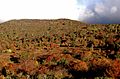
A view of the valley with some trees and open areas.
-
A closer look at the unique plant life in Graveyard Fields.
-
A stream flowing through the valley, showing the water source.
-
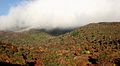
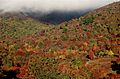
Another scenic view of the wide-open spaces in the valley.


