
Black Balsam Knob facts for kids
Quick facts for kids Black Balsam Knob |
|
|---|---|

Black Balsam Knob as seen at sunrise from Blue Ridge Parkway Milepost 419 in autumn.
|
|
| Highest point | |
| Elevation | 6,214 ft (1,894 m) |
| Prominence | 989 ft (301 m) |
| Geography | |
| Location | Haywood County, North Carolina, U.S. |
| Parent range | Great Balsam Mountains Blue Ridge Mountains |
| Topo map | USGS Shining Rock |
| Climbing | |
| Easiest route | Hike |
Black Balsam Knob, sometimes called Black Balsam Bald, is a beautiful mountain in North Carolina. It's located in the Pisgah National Forest, southwest of Asheville. You can find it near milepost 420 on the famous Blue Ridge Parkway. This mountain is special because of its unique, grassy top that gives you incredible views.
It's the second highest mountain in the Great Balsam Mountains. These mountains are part of the larger Blue Ridge Mountains, which are themselves a section of the huge Appalachian Mountains. Black Balsam Knob is also one of the tallest mountains in North Carolina, standing over 6,000 feet high.
Contents
What Makes Black Balsam Knob Special?
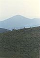
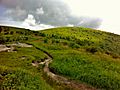
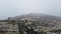
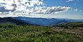
The very top of Black Balsam Knob is a "grassy bald." This means it's a wide-open area covered in grass, with very few trees. From here, you can see for miles and miles in every direction!
How Did the Grassy Balds Form?
These grassy balds in the southern part of Haywood County have an interesting history. Long ago, there was a lot of tree cutting (logging) in the area. Then, in 1925 and 1942, big fires started by trains burned deep into the soil. These fires made it very hard for new trees to grow back. This is why you see grassy balds on Black Balsam Knob and other nearby peaks.
The Art Loeb Trail, a popular hiking path, follows the grassy ridge of Black Balsam Knob. Many people love to visit this area because of its beauty. However, with lots of visitors, it's important to stay on marked trails. This helps protect the plants and animals that live there from damage.
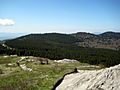
Amazing Views from the Top
When you stand on Black Balsam Knob, you can see many other mountains in the distance. It's like looking at a giant map!
Here are some of the peaks you might spot:
- Shining Rock is about 3 miles northeast. It's in the Shining Rock Wilderness.
- Looking Glass Rock is about 5 miles southeast.
- Cold Mountain is about 6 miles north.
- Mount Pisgah is about 9.5 miles northeast.
- On very clear days, you might even see Mount Mitchell. Mount Mitchell is the highest point in the Eastern United States, and it's about 45 miles northeast!
Images for kids
-
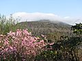
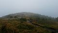
View of summit of Black Balsam Knob covered by early morning spring haze.
-
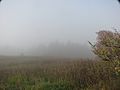
On summit of Black Balsam Knob during early morning spring haze.
-
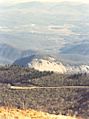
Shining Rock 3 miles in the distance as seen from Black Balsam Knob.
-
Looking Glass Rock 5 miles in the distance as seen from Black Balsam Knob.
-
Mount Pisgah 9.5 miles in the distance as seen from Black Balsam Knob.
-
View from Black Balsam Knob
-
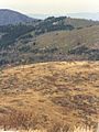
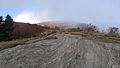
Summit of Black Balsam Knob
-
Black Balsam in early spring.
-
Black Balsam in late summer.
-
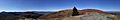
Panorama view in the fall.
-
A beautiful view at Black Balsam.
-
View from the peak of Black Balsam.


See also
- Art Loeb Trail
- Blue Ridge Parkway
- Pisgah National Forest
