Cold Mountain (North Carolina) facts for kids
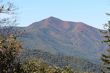
Cold Mountain is a tall and beautiful mountain located in the western part of North Carolina, United States. It's part of the Great Balsam Mountains, which are a smaller group within the larger Blue Ridge Mountains. These mountains are all part of the huge Appalachian Mountains chain. Cold Mountain and the wild area around it, called the Shining Rock Wilderness, are protected as part of the Pisgah National Forest.
Quick facts for kids Cold Mountain |
|
|---|---|

Cold Mountain as seen from the Blue Ridge Parkway
|
|
| Highest point | |
| Elevation | 6,030 ft (1,840 m) |
| Prominence | 990 ft (300 m) |
| Geography | |
| Location | Haywood County, North Carolina, U.S. |
| Parent range | Great Balsam Mountains |
| Topo map | USGS Cruso |
| Climbing | |
| Easiest route | Hike |
Contents
About Cold Mountain
Cold Mountain is located about 15 miles (24 kilometers) southeast of Waynesville. It is also about 35 miles (56 kilometers) south of Asheville. The mountain rises to 6,030 feet (1,838 meters) above sea level. This makes it one of the tallest mountains in the eastern United States. In fact, it's the 40th tallest!
Exploring Cold Mountain
Most of Cold Mountain is part of the Shining Rock Wilderness. This is a special protected area within the Pisgah National Forest. This means it's kept wild for nature and people to enjoy.
You can reach the top of Cold Mountain by hiking. The trail is called the Art Loeb Trail. It's a very challenging hike, about 10.6 miles (17 kilometers) round trip. Hikers gain about 2,800 feet (853 meters) in elevation. This means you climb quite a bit from the start of the trail to the peak!
Land Around the Mountain
While most of Cold Mountain is federal land, some parts are privately owned. For example, about 800 acres (324 hectares) on the northwest side belong to private owners. There are a few homes on this side of the mountain.
In 2016, a group called the Southern Appalachian Highland Conservancy bought 162 acres (66 hectares) of land. This land was then given to the N.C. Wildlife Resources Commission. This helped to make the nearby Cold Mountain Game Lands bigger. By 2017, these game lands grew to about 3,500 acres (1,416 hectares). This helps protect more of the area's wildlife.
Mountain History
Much of the land that makes up the Pisgah National Forest was once owned by George Washington Vanderbilt II. He was famous for building the Biltmore Estate. After he passed away, his wife sold the land, including Cold Mountain, to the United States Forest Service. She sold it for a low price of $5 an acre. This sale helped create the Pisgah National Forest. It was the very first National Forest in the eastern United States.
Plane Crash on Cold Mountain
On September 16, 1946, a military plane crashed near the top of Cold Mountain. The plane was a TB-25J Mitchell bomber. Major General Paul Wurtsmith was flying the plane. Four other crew members were also on board. Sadly, all five people died in the crash.
Years later, in 1953, an air force base was renamed in memory of General Wurtsmith. It became known as Wurtsmith Air Force Base. This was done to honor him and the others who lost their lives in the crash.
 | Georgia Louise Harris Brown |
 | Julian Abele |
 | Norma Merrick Sklarek |
 | William Sidney Pittman |

