Gray, Georgia facts for kids
Quick facts for kids
Gray, Georgia
|
|||
|---|---|---|---|
 |
|||
|
|||
| Motto(s):
Home of the annual Daylily Festival
|
|||

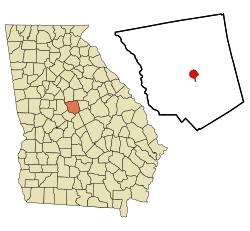
Location in Jones County and the state of Georgia
|
|||
| Country | United States | ||
| State | Georgia | ||
| County | Jones | ||
| Area | |||
| • Total | 3.95 sq mi (10.22 km2) | ||
| • Land | 3.94 sq mi (10.20 km2) | ||
| • Water | 0.01 sq mi (0.02 km2) | ||
| Elevation | 603 ft (183 m) | ||
| Population
(2020)
|
|||
| • Total | 3,436 | ||
| • Density | 872.75/sq mi (336.93/km2) | ||
| Time zone | UTC-5 (Eastern (EST)) | ||
| • Summer (DST) | UTC-4 (EDT) | ||
| ZIP code |
31032
|
||
| Area code(s) | 478 | ||
| FIPS code | 13-34512 | ||
| GNIS feature ID | 0327996 | ||
Gray is a city located in Jones County, Georgia, in the United States. It's known as the main city, or county seat, of Jones County. Gray is also part of the larger Macon area. In 2020, about 3,436 people lived here.
Contents
History of Gray, Georgia
Gray was first established in the 1850s. The city was named after a local person called James M. Gray. Later, in 1905, Gray became the official county seat for Jones County. This means it became the main city where the county government is located.
Geography and Location
Gray is found in the middle of Jones County. You can find its exact spot using coordinates: Lua error in Module:Coordinates at line 614: attempt to index field 'wikibase' (a nil value).. Several important roads pass through or near Gray.
Major Roads and Nearby Cities
U.S. Route 129 goes right through the center of Gray. This road connects Gray to Eatonton, which is about 25 miles (40 km) northeast. It also leads southwest to Macon, which is about 14 miles (23 km) away.
Other state routes also connect Gray to different towns:
- State Route 11 goes northwest to Monticello, about 25 miles (40 km) away.
- State Route 22 heads east to Milledgeville, about 19 miles (31 km) away.
- State Route 18 travels southeast to Gordon, about 15 miles (24 km) away.
Land and Water Features
The United States Census Bureau reports that Gray covers a total area of about 3.9 square miles (10.1 square kilometers). Most of this area is land. Only a very small part, about 0.01 square miles (0.03 square kilometers), is water.
Water flows from Gray in two main directions. To the west, small streams flow into Walnut Creek, which then joins the Ocmulgee River. To the east, other streams flow into Commissioner Creek, which eventually reaches the Oconee River.
Population and Demographics
Demographics is the study of a population, looking at things like how many people live somewhere and what groups they belong to.
Population Growth Over Time
The number of people living in Gray has changed over the years. Here's a quick look at the population counts from different U.S. Censuses:
- 1920: 559 people
- 1930: 653 people
- 1940: 698 people
- 1950: 866 people
- 1960: 1,320 people
- 1970: 2,014 people
- 1980: 2,145 people
- 1990: 2,189 people
- 2000: 1,811 people
- 2010: 3,276 people
- 2020: 3,436 people
As of the 2020 United States census, there were 3,436 people living in Gray. These people made up 1,219 households, and 798 of these were families.
Education in Gray
The schools in Gray are part of the Jones County School District. This district provides education for students from pre-school all the way up to twelfth grade.
Jones County School District Overview
The Jones County School District has a total of 295 full-time teachers. They teach over 5,014 students across the district. The district includes different types of schools to serve all age groups.
Schools in the District
The district has several schools, including:
- Elementary Schools:
- Dames Ferry Elementary School
- Turnerwoods Elementary School
- Gray Elementary School
- Mattie Wells Elementary School
- Middle Schools:
- Gray Station Middle School
- Clifton Ridge Middle School
- High School:
- Jones County High School
See also
 In Spanish: Gray (Georgia) para niños
 | Jewel Prestage |
 | Ella Baker |
 | Fannie Lou Hamer |


