Grayson, California facts for kids
Quick facts for kids
Grayson, California
|
|
|---|---|
 |
|

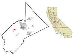
Location in Stanislaus County and the state of California
|
|
| Country | United States |
| State | California |
| County | Stanislaus |
| Area | |
| • Total | 2.549 sq mi (6.602 km2) |
| • Land | 2.549 sq mi (6.602 km2) |
| • Water | 0 sq mi (0 km2) 0% |
| Elevation | 52 ft (16 m) |
| Population
(2020)
|
|
| • Total | 1,041 |
| • Density | 408.40/sq mi (157.68/km2) |
| Time zone | UTC-8 (Pacific (PST)) |
| • Summer (DST) | UTC-7 (PDT) |
| ZIP code |
95363
|
| Area code(s) | 209 |
| FIPS code | 06-30882 |
| GNIS feature ID | 1658661 |
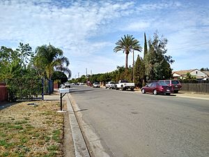
Grayson is a small community in Stanislaus County, California, United States. It's called an "unincorporated community" because it doesn't have its own city government. The U.S. Census Bureau counts it as a "census-designated place" (CDP) for statistics. In 2020, about 1,041 people lived there. Grayson is also part of the larger Modesto area.
Contents
History of Grayson
Grayson was once known as Graysonville or Grayson City. It was started by a group of seven men. One of these men was Andrew Jackson Grayson (1818–1869). He moved his family to California in 1846. Andrew Jackson Grayson was a self-taught artist who painted with watercolors. He was also an expert on birds found along the Pacific Coast.
Graysonville used to be a busy stop for steamboats on the San Joaquin River. This was especially true during the California Gold Rush. However, steamboat traffic stopped when river water was used more for farming. In 2019, a car club called No Dice made Grayson its home.
Where is Grayson Located?
Grayson is a small area, covering about 2.5 square miles (6.5 km2) of land. It is located where the San Joaquin River and the Tuolumne River meet.
Who Lives in Grayson?
| Historical population | |||
|---|---|---|---|
| Census | Pop. | %± | |
| U.S. Decennial Census | |||
Grayson's Population in 2010
In 2010, the 2010 United States Census counted 952 people living in Grayson. The community had about 373 people per square mile.
Most people in Grayson were from different backgrounds:
- 47.8% were White.
- 1.8% were African American.
- 0.4% were Native American.
- 0.3% were Asian.
- 43.8% were from other races.
- 5.9% were from two or more races.
- A large number, 86.0%, identified as Hispanic or Latino.
All 952 people lived in homes, not in group housing or institutions. There were 250 households in total. Many households (57.2%) had children under 18 living there. The average household had about 3.81 people.
The population included:
- 33.4% under 18 years old.
- 10.9% aged 18 to 24.
- 27.3% aged 25 to 44.
- 21.4% aged 45 to 64.
- 6.9% were 65 years or older.
The average age in Grayson was 29 years.
Most homes (64.4%) were owned by the people living in them. The rest (35.6%) were rented.
Grayson's Population in 2000
In the census of 2000, Grayson had 1,077 people. There were 274 households. The population density was about 401 people per square mile.
The racial makeup included:
- 41.69% White.
- 1.11% African American.
- 1.21% Native American.
- 0.56% Asian.
- 50.14% from other races.
- 5.20% from two or more races.
- About 72.14% of the population was Hispanic or Latino.
Many households (54.4%) had children under 18. The average household size was 3.93 people.
The population included:
- 35.8% under 18 years old.
- 9.6% from 18 to 24.
- 31.8% from 25 to 44.
- 16.5% from 45 to 64.
- 6.2% were 65 years or older.
The average age was 28 years.
Water in Grayson
The water underground in Grayson has nitrates, which can be harmful. Because of this, the drinking water is specially treated. It goes through a process called "ion exchange" to make it safe to drink.
See also
 In Spanish: Grayson (California) para niños
 | Frances Mary Albrier |
 | Whitney Young |
 | Muhammad Ali |


