Great Ditch facts for kids
Quick facts for kids Great Ditch |
|
|---|---|

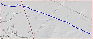
Great Ditch map
|
|
| Country | United States |
| Physical characteristics | |
| Main source | 89 ft (27 m) 40°23′5″N 74°28′57″W / 40.38472°N 74.48250°W |
| River mouth | 40°23′39″N 74°30′27″W / 40.39417°N 74.50750°W |
| Basin features | |
| Progression | Lawrence Brook, Raritan River, Atlantic Ocean |
| River system | Raritan River system |
The Great Ditch is a special kind of waterway, like a small canal, located in New Jersey, United States. It helps drain water from a place called Pigeon Swamp State Park. Think of it as a helpful channel that guides water away from areas that might get too wet.
Where Does the Great Ditch Start and Go?
The Great Ditch begins its journey in Pigeon Swamp State Park. Its starting point is around 40°23′5″N 74°28′57″W / 40.38472°N 74.48250°W. From there, it flows towards the west.
As it travels, the ditch crosses over Fresh Ponds Road and then goes under Route 130. Eventually, the Great Ditch joins another stream near 40°23′39″N 74°30′27″W / 40.39417°N 74.50750°W. This stream then flows into the Lawrence Brook, which is a larger waterway.
Why Is the Great Ditch Important?
The main reason the Great Ditch was created is to help prevent flooding. It acts like a drain for parts of the Pigeon Swamp. By moving water away, it keeps Deans Rhode Hall Road, which runs through the swamp, from getting flooded. This makes sure the road stays safe and usable for everyone.
Other Waterways Nearby
The Great Ditch is part of a network of streams and brooks in the area. Some of its "sister" waterways, meaning other streams that are connected to the same larger river system, include:
- Beaverdam Brook
- Ireland Brook
- Oakeys Brook
- Sawmill Brook
- Sucker Brook
- Terhune Run
- An unnamed brook in Rutgers Gardens, sometimes called Doc Brook
- Another unnamed brook found in Rutgers' Helyar Woods
 | Precious Adams |
 | Lauren Anderson |
 | Janet Collins |

