Greenview, Illinois facts for kids
Quick facts for kids
Greenview, Illinois
|
|
|---|---|

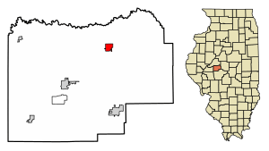
Location in Menard County, Illinois
|
|
| Country | United States |
| State | Illinois |
| County | Menard |
| Township | Greenview No. 6 Precinct |
| Area | |
| • Total | 0.86 sq mi (2.23 km2) |
| • Land | 0.86 sq mi (2.23 km2) |
| • Water | 0.00 sq mi (0.00 km2) |
| Elevation | 538 ft (164 m) |
| Population
(2020)
|
|
| • Total | 745 |
| • Density | 867.29/sq mi (334.82/km2) |
| Time zone | UTC-6 (CST) |
| • Summer (DST) | UTC-5 (CDT) |
| ZIP code |
62642
|
| Area code(s) | 217 |
| FIPS code | 17-31576 |
| GNIS feature ID | 2398205 |
| Wikimedia Commons | Greenview, Illinois |
Greenview is a small village located in Menard County, Illinois, in the United States. In 2020, about 745 people lived there. It is part of the larger Springfield, Illinois area.
History of Greenview
Greenview was first planned out in October 1857. A pioneer from Menard County named William Engle created the village. The land originally belonged to Charles Montgomery.
The village was named after William G. Greene. He was important because he helped convince the railroad company to build tracks through the town. This was a big deal for the village's growth. Greenview is located along the Chicago, Alton & St. Louis Railroad line.
Greenview officially became a village on May 6, 1869, through a special law passed by the Illinois General Assembly. Later, on March 7, 1877, it was re-established under the state's general laws for towns.
Geography of Greenview
Greenview is found in the northeastern part of Menard County. Illinois Route 29 runs along the eastern edge of the village. This road goes north about 9 miles (14 km) to Mason City and south the same distance to Athens.
Springfield, which is the state capital, is about 23 miles (37 km) south of Greenview via Route 29. Petersburg, the main town of Menard County, is about 10 miles (16 km) southwest using local roads.
The U.S. Census Bureau says that Greenview covers a total area of about 0.86 square miles (2.23 square kilometers). All of this area is land. Grove Creek flows through the eastern part of the village. This creek eventually joins Salt Creek and then the Sangamon River, which is part of the larger Illinois River system.
Population and People
| Historical population | |||
|---|---|---|---|
| Census | Pop. | %± | |
| 1870 | 373 | — | |
| 1880 | 450 | 20.6% | |
| 1890 | 1,106 | 145.8% | |
| 1900 | 1,019 | −7.9% | |
| 1910 | 921 | −9.6% | |
| 1920 | 755 | −18.0% | |
| 1930 | 720 | −4.6% | |
| 1940 | 749 | 4.0% | |
| 1950 | 795 | 6.1% | |
| 1960 | 796 | 0.1% | |
| 1970 | 740 | −7.0% | |
| 1980 | 830 | 12.2% | |
| 1990 | 848 | 2.2% | |
| 2000 | 862 | 1.7% | |
| 2010 | 778 | −9.7% | |
| 2020 | 745 | −4.2% | |
| U.S. Decennial Census | |||
The census is a count of the population. In 2000, there were 862 people living in Greenview. These people lived in 366 different homes, and 252 of these were families. The village had about 1,014 people per square mile (391 people per square kilometer).
Most people in Greenview were White (99.65%). A very small number were African American, Native American, or Asian. About 0.12% of the population was Hispanic or Latino.
In 2000, about 31.4% of homes had children under 18 living there. More than half (52.7%) were married couples. About 12.0% of homes had a female head of household with no husband. Around 29.5% of all homes were single-person households.
The average age of people in Greenview was 37 years old. About 24.4% of the population was under 18. Around 17.9% were 65 years or older. For every 100 females, there were about 95 males.
The average income for a household in the village was $39,196. For families, the average income was $49,125. The per capita income (income per person) for the village was $21,050. About 7.5% of the population lived below the poverty line. This included 13.7% of those under 18 and 7.1% of those 65 or older.
See also
 In Spanish: Greenview (Illinois) para niños
 | Jessica Watkins |
 | Robert Henry Lawrence Jr. |
 | Mae Jemison |
 | Sian Proctor |
 | Guion Bluford |


