Greenwood, Missouri facts for kids
Quick facts for kids
Greenwood, Missouri
|
|
|---|---|

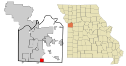
Location of Greenwood, Missouri in Jackson County
|
|
| Country | |
| State | |
| Counties | Jackson Cass |
| Founded | 1867 |
| Area | |
| • Total | 5.23 sq mi (13.54 km2) |
| • Land | 5.22 sq mi (13.51 km2) |
| • Water | 0.01 sq mi (0.03 km2) |
| Elevation | 915 ft (279 m) |
| Population
(2020)
|
|
| • Total | 6,021 |
| • Density | 1,153.89/sq mi (445.56/km2) |
| Time zone | UTC-6 (Central (CST)) |
| • Summer (DST) | UTC-5 (CDT) |
| ZIP code |
64034
|
| Area code(s) | 816 |
| FIPS code | 29-29494 |
| GNIS feature ID | 2394246 |
Greenwood is a city located in Missouri, a state in the United States. It's found in two counties: Jackson County and Cass County. Greenwood is also part of the larger Kansas City metropolitan area, which is a big group of cities and towns around Kansas City. In 2020, about 6,021 people lived here.
Contents
History of Greenwood
Greenwood was first planned out in 1867. Before that, a post office had already opened in the area in 1866. Many years later, in 1963, Greenwood officially became an incorporated city. This means it gained its own local government.
Geography and Landscape
Greenwood covers an area of about 5.23 square miles (13.54 square kilometers). The city's land is mostly flat. A small creek flows through the southwest part of town.
The area northeast of the railway line has open fields and light woods. You can also find several small ponds there. Southwest of the railway, the area is more suburban. This part has many houses and a small downtown area.
Population and People
Greenwood has grown quite a bit over the years. Here's how its population has changed:
| Historical population | |||
|---|---|---|---|
| Census | Pop. | %± | |
| 1880 | 234 | — | |
| 1890 | 296 | 26.5% | |
| 1960 | 488 | — | |
| 1970 | 925 | 89.5% | |
| 1980 | 1,315 | 42.2% | |
| 1990 | 1,505 | 14.4% | |
| 2000 | 3,952 | 162.6% | |
| 2010 | 5,221 | 32.1% | |
| 2020 | 6,021 | 15.3% | |
| U.S. Decennial Census | |||
Greenwood's Population in 2010
In 2010, about 5,221 people lived in Greenwood. There were 1,769 households, which means 1,769 homes or groups of people living together. Most people living in Greenwood were White (91.7%). Other groups included African American (5.1%), Native American (0.3%), and Asian (0.5%). About 3.4% of the population identified as Hispanic or Latino.
Many households (51%) had children under 18 living with them. About 66% of households were married couples. The average age of people in Greenwood was about 32 years old. Many residents (32.6%) were under 18, showing it's a city with many young people and families.
Education in Greenwood
Students in Greenwood attend schools that are part of the Lee's Summit R-VII School District. This district serves several communities, including parts of Greenwood.
Elementary Schools
Several elementary schools serve Greenwood. These include Greenwood Elementary, which is located right in Greenwood. Other elementary schools like Sunset Valley and Woodland, located in Lee's Summit, also serve parts of the city.
Middle Schools
After elementary school, students go to middle school. Students from Greenwood Elementary usually attend Summit Lakes Middle School. Those from Sunset Valley and Woodland elementary schools are typically zoned for East Trails Middle School.
High Schools
For high school, most students from Summit Lakes Middle School go to Lee's Summit West High School. This school is located in southern Lee's Summit. A smaller number of students from the East Trails area in Greenwood attend Lee's Summit High School, which is closer to downtown Lee's Summit.
Transportation Routes
Route 150 is an important highway that connects Greenwood to other nearby cities. This route links Greenwood to southern Lee's Summit, Grandview, and even to Overland Park in Kansas. It helps people travel easily between these areas.
See also
 In Spanish: Greenwood (Misuri) para niños
 | Aurelia Browder |
 | Nannie Helen Burroughs |
 | Michelle Alexander |

