Gregory River (Australia) facts for kids
Quick facts for kids Gregory |
|
|---|---|
|
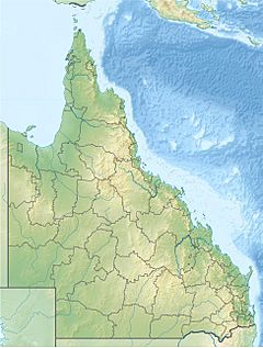
Location of Gregory River mouth in Queensland
|
|
| Native name | Ngumarryina |
| Country | Australia |
| Territory and State | Northern Territory, Queensland |
| Physical characteristics | |
| Main source | Barkly Tableland Northern Territory 263 m (863 ft) |
| River mouth | Nicholson River southwest of Burketown, Queensland 11 m (36 ft) 17°53′52″S 139°17′06″E / 17.89778°S 139.28500°E |
| Length | 321 km (199 mi) |
| Basin features | |
| River system | Nicholson River catchment |
| Basin size | 24,179 km2 (9,336 sq mi) |
The Gregory River is a special river in Australia. It flows through the Northern Territory and Queensland. The Waanyi people, who are the traditional owners, call it Ngumarryina.
This river is very important because it's the biggest river that flows all year round in the dry parts of Queensland. It's one of the few rivers in the northwest of Queensland that never dries up.
Contents
Where the River Flows
The Gregory River starts in the Northern Territory. Its source is in the north-eastern part of the Barkly Tableland. This area has gentle hills and many cattle stations.
The river gets its water from springs in small valleys. It then flows east into Queensland. Along its journey, it carves out cool canyons.
River's Journey
As the Gregory River flows, other smaller rivers join it.
- One important river is the O'Shanassy River. It joins the Gregory River near a place called Riversleigh.
- Further downstream, Lawn Hill Creek also flows into the Gregory.
Finally, the Gregory River empties into the Nicholson River. This happens southwest of Burketown. The Gregory River travels about 321-kilometre (199 mi) in total. During its journey, it drops about 252 metres (827 ft) in height.
River's Surroundings
The land around the Gregory River is called its catchment area. This area is about 24,179 square kilometres (9,336 sq mi) big. It's part of the larger Nicholson River catchment, which is about 52,234 square kilometres (20,168 sq mi).
The area where the river starts, on the Barkly Tableland, has hills made of limestone and dolomite rock. It also has canyons and flat areas called plateaus.
Water Flow and Wetlands
On average, the Gregory River carries a lot of water each year. It has important wetlands in its catchment area. Wetlands are special places where the land is covered by water, and they are home to many plants and animals.
- One wetland is the Gregory River wetland, which is about 26,639 hectares (65,826 acres) in size.
- Another large wetland is the Thorntonia Aggregation, covering about 298,888 hectares (738,568 acres).
Plants Around the River
The areas near the river's start are covered in forests. As the river flows onto the plains, you'll find woodlands along the riverbanks and open grasslands.
The grasslands have types of grass like Astrebla pectinate and Eulalia fulca. The forests along the river include trees like Corymbia papuana, Eucalyptus tectifica, and Eucalyptus microtheca.
History of the Gregory River
The Waanyi Aboriginal people are the traditional owners of the Gregory River. They have lived by this river for a very long time and know it as Ngumarryina.
European Exploration
In 1861, an explorer named William Landsborough discovered the river. He was on an expedition trying to find the missing Burke and Wills expedition.
Landsborough found the river while traveling from Burketown. He followed it all the way to the Barkly Tableland. He decided to name the river the Gregory River. He did this to honor Augustus Gregory, who was the Queensland Surveyor General and also an explorer at that time.
 | Ernest Everett Just |
 | Mary Jackson |
 | Emmett Chappelle |
 | Marie Maynard Daly |


