Grindon, Sunderland facts for kids
Quick facts for kids Grindon |
|
|---|---|
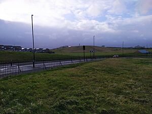
 The Grindon Sandhill as photographed from neighbouring Thorney Close, 2020 |
|
| Metropolitan borough | |
| Metropolitan county | |
| Region | |
| Country | England |
| Sovereign state | United Kingdom |
| Post town | SUNDERLAND |
| Postcode district | SR4 |
| Dialling code | 0191 |
| Police | Northumbria |
| Fire | Tyne and Wear |
| Ambulance | North East |
| EU Parliament | North East England |
| UK Parliament |
|
Grindon is a neighborhood, or suburb, located in Sunderland, Tyne and Wear, England. It's about three miles west of Sunderland's city center, along a road called Chester Road. Grindon started as a large land area owned by a lord way back in the Norman times. Later, in the 1900s, it was developed into a housing area after World War II.
Contents
Discovering Grindon's Past
What Does "Grindon" Mean?
Experts who study old languages believe the name "Grindon" comes from Old English words. It likely means "Green Hill." This name probably refers to a natural hill in the area, known today as the Sandhill.
Grindon in Old Records
The first time Grindon is mentioned in official records is in a very old book from 1183. This book is called the Boldon Book. It states that the land of Grindon was given by the Bishop of Durham to a person named Walter De Roth. This shows that Grindon has a long history, dating back many centuries.
Grindon's Changing Boundaries
In 2004, the way Grindon was grouped for local elections changed. An "electoral ward" is like a voting district. The Grindon ward was combined with a nearby area called Thorney Close. Now, this larger area is known as the Sandhill Ward. This means that for voting purposes, Grindon is part of a bigger neighborhood.
Local Schools in Grindon
Grindon is home to a well-known school called Grindon Hall Christian School. It is an independent school, which means it is not run by the local government. You can find this school on Pennywell Road.
 | Charles R. Drew |
 | Benjamin Banneker |
 | Jane C. Wright |
 | Roger Arliner Young |


