Groveland, California facts for kids
Quick facts for kids
Groveland
|
|
|---|---|

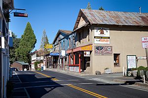
Groveland California in 2012
|
|

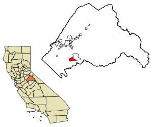
Location of Groveland in Tuolumne County, California.
|
|
| Country | |
| State | |
| County | Tuolumne |
| Area | |
| • Total | 9.567 sq mi (24.779 km2) |
| • Land | 9.561 sq mi (24.764 km2) |
| • Water | 0.006 sq mi (0.015 km2) 0.06% |
| Elevation | 3,136 ft (956 m) |
| Population
(2020)
|
|
| • Total | 540 |
| • Density | 56.4/sq mi (21.79/km2) |
| Time zone | UTC-8 (Pacific (PST)) |
| • Summer (DST) | UTC-7 (PDT) |
| ZIP Code |
95321
|
| Area code(s) | 209 |
| GNIS feature ID | 2628856 |
| Reference #: | 446 |
Groveland is a small community in Tuolumne County, California. It is a place where the government counts the population, called a census-designated place (CDP). Groveland sits high up in the mountains, about 3,136 feet (956 meters) above sea level. In 2020, about 540 people called Groveland home. It is known as a gateway town to the famous Yosemite National Park.
Groveland was made a CDP before the 2010 census. Before that, it was part of a larger area called Groveland-Big Oak Flat.
Contents
History of Groveland
Groveland has always been an important stop on the road to Yosemite National Park. The town really grew in the early 1900s. This was when the Tuolumne River Hetch-Hetchy water project was built. This project supplied water to the city of San Francisco. Groveland is next to the Stanislaus National Forest and is famous for the historic Iron Door Saloon.
Groveland started as a town during the California Gold Rush. After the gold rush, it became a quiet farming community. Then, the San Francisco Hetch Hetchy water project made Groveland its main office. They built a railroad yard and a hospital for the workers. These buildings are now gone. From 1915 to 1935, Groveland was a "boom town." This means it grew very quickly. It had seven hotels and about 10,000 residents.
When the water project was finished, the workers left. Groveland became a small stop on the way to Yosemite again. Later, the Boise Cascade company built the Pine Mountain Lake community. This development included a golf course, an airport, and a lake. They also marked out 5,000 lots for homes. This area started as a place for summer homes. Now, it has grown into a community where people live all year. This growth has helped Groveland become a popular place for travel and vacations.
Groveland is the main town on Highway 120 leading to Yosemite National Park. It has many places to stay and eat for visitors. Tioga High School and Tenaya Elementary School are also located in Groveland.
Geography and Climate
Groveland covers an area of about 9.6 square miles (24.8 square kilometers). Almost all of this area is land. Only a tiny part is water.
Groveland's Climate
Groveland has a type of weather called a Mediterranean climate. This means it has warm to very hot and dry summers. The hottest month usually has an average temperature of about 73.7 degrees Fahrenheit (23.2 degrees Celsius). Winters are mild and wet.
| Climate data for Groveland, California, 1991–2020 normals, extremes 2000–present | |||||||||||||
|---|---|---|---|---|---|---|---|---|---|---|---|---|---|
| Month | Jan | Feb | Mar | Apr | May | Jun | Jul | Aug | Sep | Oct | Nov | Dec | Year |
| Record high °F (°C) | 72 (22) |
76 (24) |
83 (28) |
87 (31) |
97 (36) |
104 (40) |
107 (42) |
105 (41) |
108 (42) |
95 (35) |
87 (31) |
75 (24) |
108 (42) |
| Mean maximum °F (°C) | 66.6 (19.2) |
69.8 (21.0) |
74.5 (23.6) |
81.7 (27.6) |
88.5 (31.4) |
98.6 (37.0) |
101.1 (38.4) |
99.7 (37.6) |
96.9 (36.1) |
86.5 (30.3) |
77.0 (25.0) |
64.9 (18.3) |
102.1 (38.9) |
| Mean daily maximum °F (°C) | 53.4 (11.9) |
55.3 (12.9) |
60.1 (15.6) |
64.8 (18.2) |
73.2 (22.9) |
83.2 (28.4) |
91.2 (32.9) |
90.7 (32.6) |
84.7 (29.3) |
73.5 (23.1) |
60.1 (15.6) |
52.0 (11.1) |
70.2 (21.2) |
| Daily mean °F (°C) | 42.2 (5.7) |
43.5 (6.4) |
47.5 (8.6) |
51.4 (10.8) |
58.6 (14.8) |
67.0 (19.4) |
73.7 (23.2) |
72.8 (22.7) |
67.3 (19.6) |
57.7 (14.3) |
47.6 (8.7) |
41.4 (5.2) |
55.9 (13.3) |
| Mean daily minimum °F (°C) | 31.0 (−0.6) |
31.7 (−0.2) |
34.8 (1.6) |
38.1 (3.4) |
44.0 (6.7) |
50.9 (10.5) |
56.3 (13.5) |
54.9 (12.7) |
49.9 (9.9) |
41.8 (5.4) |
35.1 (1.7) |
30.7 (−0.7) |
41.6 (5.3) |
| Mean minimum °F (°C) | 20.9 (−6.2) |
21.9 (−5.6) |
24.7 (−4.1) |
28.4 (−2.0) |
33.7 (0.9) |
39.0 (3.9) |
47.9 (8.8) |
47.1 (8.4) |
38.3 (3.5) |
31.4 (−0.3) |
25.5 (−3.6) |
19.1 (−7.2) |
17.3 (−8.2) |
| Record low °F (°C) | −2 (−19) |
8 (−13) |
12 (−11) |
23 (−5) |
23 (−5) |
33 (1) |
37 (3) |
40 (4) |
32 (0) |
26 (−3) |
19 (−7) |
7 (−14) |
−2 (−19) |
| Average precipitation inches (mm) | 7.20 (183) |
6.93 (176) |
6.29 (160) |
2.98 (76) |
2.24 (57) |
0.39 (9.9) |
0.00 (0.00) |
0.09 (2.3) |
0.30 (7.6) |
2.13 (54) |
3.50 (89) |
6.61 (168) |
38.66 (982.8) |
| Average snowfall inches (cm) | 1.3 (3.3) |
2.3 (5.8) |
2.6 (6.6) |
0.8 (2.0) |
0.0 (0.0) |
0.0 (0.0) |
0.0 (0.0) |
0.0 (0.0) |
0.0 (0.0) |
0.0 (0.0) |
0.7 (1.8) |
1.7 (4.3) |
9.4 (23.8) |
| Average precipitation days (≥ 0.01 in) | 9.9 | 8.5 | 10.5 | 7.2 | 4.1 | 0.9 | 0.3 | 0.6 | 1.6 | 3.9 | 8.0 | 10.1 | 65.6 |
| Average snowy days (≥ 0.1 in) | 0.3 | 0.5 | 0.5 | 0.3 | 0.0 | 0.0 | 0.0 | 0.0 | 0.0 | 0.0 | 0.4 | 0.2 | 2.2 |
| Source 1: NOAA | |||||||||||||
| Source 2: National Weather Service (mean maxima/minima 2006–2020) | |||||||||||||
People of Groveland
| Historical population | |||
|---|---|---|---|
| Census | Pop. | %± | |
| U.S. Decennial Census | |||
In 2010, the 2010 United States Census counted 601 people living in Groveland. Most of the people (about 90%) were White. There were also smaller groups of people from other backgrounds. About 8% of the population identified as Hispanic or Latino.
All 601 people lived in homes. No one lived in group homes or institutions. There were 277 households in total. About 20% of these households had children under 18 living there. The average household had about 2 people.
The population included people of all ages. About 15% were under 18 years old. About 19% were 65 years or older. The average age in Groveland was about 49.6 years.
Most homes in Groveland (about 65%) were owned by the people living in them. The rest were rented.
Fun Places Near Groveland
Several family camps are located east of Groveland, off Highway 120. These camps are within the Stanislaus National Forest. They include:
- Camp Mather, run by the City of San Francisco
- San Jose Family Camp, run by the City of San Jose
- Berkeley Tuolumne Family Camp, run by the City of Berkeley
- Camp Tawonga, which is a Jewish summer camp
See also
 In Spanish: Groveland (California) para niños
 | Delilah Pierce |
 | Gordon Parks |
 | Augusta Savage |
 | Charles Ethan Porter |


