Guadalupe County, New Mexico facts for kids
Quick facts for kids
Guadalupe County
|
|
|---|---|

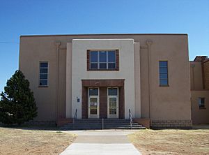
Guadalupe County Courthouse in Santa Rosa
|
|

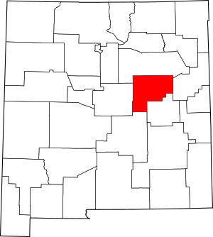
Location within the U.S. state of New Mexico
|
|
 New Mexico's location within the U.S. |
|
| Country | |
| State | |
| Founded | February 26, 1891 |
| Named for | Our Lady of Guadalupe |
| Seat | Santa Rosa |
| Largest city | Santa Rosa |
| Area | |
| • Total | 3,032 sq mi (7,850 km2) |
| • Land | 3,030 sq mi (7,800 km2) |
| • Water | 1.1 sq mi (3 km2) 0.04%% |
| Population
(2020)
|
|
| • Total | 4,452 |
| • Density | 1.4683/sq mi (0.56693/km2) |
| Time zone | UTC−7 (Mountain) |
| • Summer (DST) | UTC−6 (MDT) |
| Congressional district | 2nd |

Guadalupe County (which is Condado de Guadalupe in Spanish) is a county in the U.S. state of New Mexico. It's named after Nuestra Señora de Guadalupe, also known as Our Lady of Guadalupe.
As of the 2020 census, about 4,452 people live here. The main town and county seat is Santa Rosa. This means Santa Rosa is where the county's government offices are located.
Contents
History of Guadalupe County
Guadalupe County was created on February 26, 1891. It was formed from the southern part of San Miguel County. The county was named after Nuestra Señora de Guadalupe or the Mesita de Guadalupe (Guadalupe Plain).
The first county seat was a place called Puerto De Luna. But in 1903, the county seat was moved to Santa Rosa.
In the same year, after the Spanish–American War, the county's name was changed. It was briefly called Leonard Wood County. This was to honor Major-General Leonard Wood, a famous person from that time. However, the name was later changed back to Guadalupe County.
The county includes parts of several old Spanish land grants. These include the Aqua Negra, Jose Perea, Anton Chico, and Preston Beck land grants.
Geography of Guadalupe County
According to the U.S. Census Bureau, Guadalupe County covers a total area of 3,032 square miles. Most of this area, about 3,030 square miles, is land. Only a small part, about 1.1 square miles (0.04%), is water.
Counties Nearby
Guadalupe County shares borders with several other counties:
- San Miguel County – to the north
- Quay County – to the east
- De Baca County – to the south
- Lincoln County – to the south
- Torrance County – to the west
Population and People
| Historical population | |||
|---|---|---|---|
| Census | Pop. | %± | |
| 1900 | 5,429 | — | |
| 1910 | 10,927 | 101.3% | |
| 1920 | 8,015 | −26.6% | |
| 1930 | 7,027 | −12.3% | |
| 1940 | 8,646 | 23.0% | |
| 1950 | 6,772 | −21.7% | |
| 1960 | 5,610 | −17.2% | |
| 1970 | 4,969 | −11.4% | |
| 1980 | 4,496 | −9.5% | |
| 1990 | 4,156 | −7.6% | |
| 2000 | 4,680 | 12.6% | |
| 2010 | 4,687 | 0.1% | |
| 2020 | 4,452 | −5.0% | |
| U.S. Decennial Census 1790–1960 1900–1990 1990–2000 2010 |
|||
What the 2010 Census Showed
The 2010 census counted 4,687 people living in Guadalupe County. There were 1,766 households and 1,114 families. The county had about 1.5 people per square mile.
Most of the people in the county were white (70.4%). Other groups included American Indian (1.9%), Black or African American (1.7%), and Asian (1.3%). About 21.4% were from other races, and 3.3% were from two or more races. A large part of the population, 79.6%, was of Hispanic or Latino background.
In terms of family life, 30.6% of households had children under 18 living with them. About 40.9% were married couples. The average household had 2.33 people, and the average family had 2.93 people. The average age of people in the county was 40.1 years old.
Towns and Villages
City
- Santa Rosa (This is the county seat)
Town
Census-Designated Places
These are areas that are like towns but are not officially incorporated as cities or towns.
Education
Guadalupe County has two school districts. These districts provide education to students in different parts of the county:
- Santa Rosa Consolidated Schools
- Vaughn Municipal Schools
See also
 In Spanish: Condado de Guadalupe (Nuevo México) para niños

