Gull River (Balsam Lake) facts for kids
Quick facts for kids Gull River |
|
|---|---|

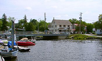
Gull River at Coboconk
|
|

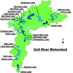
The Gull River drainage basin
|
|
|
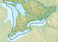
Location of the mouth of the Gull River in southern Ontario.
|
|
| Country | Canada |
| Province | Ontario |
| County | Haliburton |
| Municipalities |
|
| Physical characteristics | |
| Main source | Longboot Lake Southern Algonquin Provincial Park in Dysart et al, Haliburton County 457 m (1,499 ft) 45°13′16″N 78°16′00″W / 45.22111°N 78.26667°W |
| River mouth | Balsam Lake Coboconk, Kawartha Lakes 256.3 m (841 ft) 44°38′28″N 78°48′19″W / 44.64111°N 78.80528°W |
| Basin features | |
| River system | Great Lakes Basin |
| Tributaries |
|
The Gull River is a river in south-central Ontario, Canada. It flows through areas like Algonquin Highlands, Dysart et al, Haliburton County, and Kawartha Lakes. This river is part of the larger Trent River and Lake Ontario water systems. It starts in the southern part of Algonquin Provincial Park and ends at Balsam Lake. Balsam Lake is also a key part of the Trent–Severn Waterway, a famous canal system.
Contents
Where Does the Name "Gull River" Come From?
No one is completely sure how the Gull River got its name. One idea is that it comes from the name of the nearby village, Coboconk. The name Coboconk might come from an Ojibwa word, Quash-qua-be-conk. This word means "where the gulls nest."
Before April 1, 1859, the town of Minden, which is about 30 kilometres (19 miles) north, was actually called Gull River.
The River's Journey
The Gull River starts at Longboot Lake in Haliburton County. This area is in the southern part of Algonquin Provincial Park. It is also just south of the York River, which flows into the Ottawa River drainage basin.
The river leaves Longboot Lake towards the southeast. It then makes a big loop, flowing east, south, west, and northwest. Finally, it reaches Percy Lake.
History of the Gull River System
The Gull River and its connected lakes are very important for the Trent–Severn Waterway. This waterway is a system of canals and rivers that connects Lake Ontario to Lake Huron.
In the 1800s, people built special dams called cofferdams on the lakes. This was done to control the river's flow all year round. At first, this helped lumberjacks. They used the river to float logs downstream to Trenton after the spring floods.
Later, the dams served another purpose. In 1873, a lock was finished between Balsam Lake and Cameron Lake. This lock connected Trenton with Coboconk. To make sure steamboats could pass through, Balsam Lake's water level was raised by 5 metres (16 feet).
Since then, the Gull River has been a vital part of the Trent-Severn Waterway. The water levels in the lakes are carefully watched. This helps keep the water supply steady and protects the many cottages along the lakes. Water levels usually rise in spring (when snow melts) and late fall. They typically return to normal by mid-June. The lowest water levels are usually in late winter.
Many of the properties along the lower Gull River system were divided into long, narrow lots in the 1830s. These lots later became the sites for the many cottages you see there today.
Geology and Scenery
The southernmost lake in the Gull River system is Silver Lake. This lake sits right on the border between two different types of rock. To the north is the ancient granite of the Canadian Shield. To the south are younger Limestone layers.
North of Silver Lake, the lakes and rivers twist and turn. They wind through mountains and valleys that were shaped by glaciers. These huge ice sheets moved across the land at the end of the last ice age. This movement created the beautiful, untouched wilderness you see today. Because of this amazing scenery, Highway 35, which goes through the area, is known as one of Ontario's most scenic roads.
Fun on the River
An artificial white water course was built in Minden. This course has made the Gull River famous among white water rafting fans and kayakers. It's a great spot for exciting water sports!
Rivers that Join the Gull River
- Boshkung River (joins from the right side)
- Kennisis River (joins from the right side)
- Redstone River
 | Percy Lavon Julian |
 | Katherine Johnson |
 | George Washington Carver |
 | Annie Easley |


