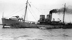
HMT Agate (1933) facts for kids

HM Trawler Agate
|
|
Quick facts for kids History |
|
|---|---|
| Name | HM Trawler Agate |
| Owner | Originally built for Boston Deep Sea Fishing and Ice Company Ltd |
| Operator | Royal Navy |
| Builder | Smiths Dock, South Bank-on-Tees, Middlesbrough |
| Laid down | 1932 |
| Launched | 18 December 1933 |
| Acquired | By the Royal Navy in 1935 |
| Fate | Became stranded becoming a total Wreck on Haisborough Sands off the Norfolk coast, England |
| Notes | Mercantile Type (First Group) Anti Submarine. |
| General characteristics | |
| Class and type | HM Trawler No: T87 |
| Tonnage | 433 gross register tons (GRT) |
| Length | 157.25 ft (47.93 m) |
| Beam | 26.5 ft (8.1 m) |
| Draft | 13 ft (4.0 m) |
| Installed power | 3 cylinder triple expansion supplied by Smiths Dock |
| Speed | 12 knots (22 km/h) |
| Crew | 16 |
HM Trawler Agate was a ship bought by the Royal Navy in 1935. Originally, she was a fishing boat called a trawler. The Navy changed her to help find and fight enemy submarines.
In 1941, the Agate was part of a group of ships protecting other vessels. This group was called an escort flotilla. On August 6, 1941, while escorting a group of ships known as convoy FS559, the Agate hit the bottom of the sea. This happened at a dangerous sandbank called Haisborough Sands off the coast of Norfolk, England. The ship was completely destroyed, and sixteen crew members sadly lost their lives.
Contents
Building and Early Life of HM Trawler Agate
HM Trawler Agate was built in 1934. She was made at Smiths Dock in Middlesbrough, England. A company called Boston Deep Sea Fishing and Ice Company had ordered her. This company was based in Fleetwood, Lancashire.
When she was first built, the trawler had a different name: Mavis Rose. She was a good-sized ship, about 433 tons. This means she was quite large for a trawler. She was also about 48 meters (157 feet) long. Her width, or beam, was about 8 meters (26.5 feet).
The Final Journey of HM Trawler Agate
On August 5, 1941, a group of ships called Convoy FS 559 was sailing down the east coast of Britain. They were heading from Newcastle to London. A convoy is a group of ships traveling together, usually for safety.
This convoy was being protected by several Royal Navy ships. Two of these were older destroyers: HMS Vimiera and HMS Wolsey. Destroyers are fast warships. Also helping with protection were HM Trawler Agate and HM Trawler Arkwright.
As night came, the weather got very bad. There was a strong gale, which is a very strong wind, blowing from the north-north-west. It was raining and cold, and it was hard to see. By the early morning of August 6, a thick sea mist covered everything. This made it almost impossible to see.
Running Aground: What Happened?
The convoy was supposed to see a special light from the Haisborough light vessel. This light helps ships know where they are. But because of the war, the light was only on for ten minutes when a convoy was expected. The bad weather and poor visibility meant the ships could not see the light.
It is believed that the combination of the storm, strong ocean currents, and not knowing their exact location caused the accident. HM Agate led seven other ships in the convoy onto the sandbanks. They all got stuck, or "ran aground."
One ship, the SS Oxshott, reported that HM Agate was heading right towards it. The Oxshott was the first of the seven ships to get stuck. The other ships were the SS Afon Towy, SS Deerwood, SS Betty Hindley, SS Aberhill, SS Gallois, and the SS Taara.
Lifeboats from Cromer and Great Yarmouth and Gorleston rushed to help. They rescued 137 men from the wrecked ships. However, 37 men died in the accident. This included 16 men from HM Trawler Agate. All three officers on the Agate were lost. Eight men from the Agate survived, and five of them were picked up from a life raft by another trawler, HM Trawler Basset.
Where the Wreck of HM Trawler Agate Is Today
The wreck of HM Trawler Agate can still be found today. It rests on the Haisborough Sands.
- The exact location is 52°53′N 01°43′E / 52.883°N 1.717°E.
- It is about 10 meters (33 feet) deep.
- This spot is about 24.1 kilometers (15 miles) north of Hemsby.
- It is also about 24.2 kilometers (15 miles) east-north-east of North Walsham.
- And about 27.9 kilometers (17 miles) north of Caister on Sea.
- Finally, it is about 28.2 kilometers (17.5 miles) east of Cromer.
 | Mary Eliza Mahoney |
 | Susie King Taylor |
 | Ida Gray |
 | Eliza Ann Grier |

