Hagerstown, Indiana facts for kids
Quick facts for kids
Hagerstown, Indiana
|
|
|---|---|
 |
|

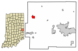
Location of Hagerstown in Wayne County, Indiana
|
|
| Country | |
| State | |
| County | Wayne |
| Township | Jefferson |
| Area | |
| • Total | 1.32 sq mi (3.42 km2) |
| • Land | 1.32 sq mi (3.41 km2) |
| • Water | 0.00 sq mi (0.01 km2) |
| Elevation | 981 ft (299 m) |
| Population
(2020)
|
|
| • Total | 1,681 |
| • Density | 1,275.42/sq mi (492.35/km2) |
| Time zone | UTC-5 (Eastern (EST)) |
| • Summer (DST) | UTC-4 (EDT) |
| ZIP code |
47346
|
| Area code(s) | 765 |
| FIPS code | 18-30402 |
| GNIS feature ID | 2396981 |
| Website | http://www.hagerstown.in.gov/ |
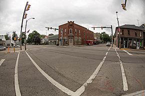
Hagerstown is a small town located in Wayne County, Indiana, in the United States. It is part of Jefferson Township. In 2020, about 1,681 people lived there. Hagerstown is a friendly community with a rich history and interesting places to visit.
Contents
History of Hagerstown
Hagerstown was first planned out in 1832. It was named after a city called Hagerstown, Maryland. The town's post office has been open since 1836.
An important part of Hagerstown's past is the Whitewater Canal. This canal was built in the mid-1800s. It helped transport goods and people. The northern end of the canal is in Hagerstown. The Hagerstown Canal Company helped pay for this part of the canal.
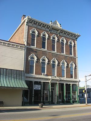
Two historic buildings in Hagerstown are very special. They are the Hagerstown I.O.O.F. Hall and the John and Caroline Stonebraker House. Both are listed on the National Register of Historic Places. This means they are important historical sites.
Where is Hagerstown?
Hagerstown is in the Midwestern United States. It is about 61 miles (98 km) east-northeast of Indianapolis, Indiana. It is also 17 miles (27 km) northwest of Richmond, Indiana. And it's about 63 miles (101 km) west-northwest of Dayton, Ohio.
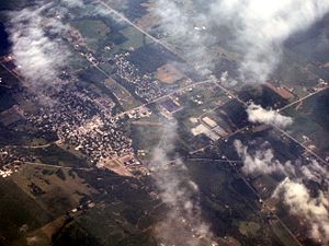
The land around Hagerstown is mostly flat. It is about 1,000 feet (305 meters) above sea level. This flat land is mainly used for farming. According to the 2010 census, Hagerstown covers about 1.34 square miles (3.47 square kilometers) of land. There is no water area within the town limits.
People of Hagerstown
The population of Hagerstown has changed over the years. Here is how many people have lived in the town during different census years:
| Historical population | |||
|---|---|---|---|
| Census | Pop. | %± | |
| 1850 | 606 | — | |
| 1860 | 638 | 5.3% | |
| 1870 | 830 | 30.1% | |
| 1880 | 892 | 7.5% | |
| 1890 | 873 | −2.1% | |
| 1900 | 862 | −1.3% | |
| 1910 | 936 | 8.6% | |
| 1920 | 1,238 | 32.3% | |
| 1930 | 1,262 | 1.9% | |
| 1940 | 1,638 | 29.8% | |
| 1950 | 1,694 | 3.4% | |
| 1960 | 1,730 | 2.1% | |
| 1970 | 2,059 | 19.0% | |
| 1980 | 1,950 | −5.3% | |
| 1990 | 1,835 | −5.9% | |
| 2000 | 1,768 | −3.7% | |
| 2010 | 1,787 | 1.1% | |
| 2020 | 1,681 | −5.9% | |
| U.S. Decennial Census | |||
2010 Census Information
In 2010, there were 1,787 people living in Hagerstown. There were 751 households, which are groups of people living in one home. The town had about 1,334 people per square mile (515 people per square kilometer).
Most of the people in Hagerstown were White (97.7%). A small number were African American (0.6%), Native American (0.2%), or Asian (0.3%). About 1.2% of the people were from two or more races. About 0.8% of the population was Hispanic or Latino.
The average age of people in Hagerstown was 37.9 years old. About 25.6% of residents were under 18 years old. And 17.9% were 65 years or older.
Fun Places to Visit
Hagerstown has several interesting places to explore:
- Hartley Hills Golf Club and Event Center: A place for golf and special events.
- Abbott's Candy: A local candy factory where you can find tasty treats.
- Nettle Creek Valley Museum: Learn about the history of the area.
- Hagerstown Park: A great spot with a playground, hiking trails, sports fields, and picnic areas.
- Hagerstown Nature Preserve: Enjoy nature and wildlife.
- Wilbur Wright Birthplace and Museum: Located near Hagerstown, this museum celebrates the birthplace of Wilbur Wright, one of the famous Wright brothers who invented the airplane.
- Tedco Toys: This company makes educational and science toys. They are known for their gyroscopes and are the world's largest maker of toy gyroscopes.
Education in Hagerstown
Students in Hagerstown attend local schools.
- Hagerstown Elementary
- Hagerstown Jr./Sr. High School
These schools serve students from Hagerstown and nearby communities. The high school has a large campus with an outdoor science lab and sports facilities.
The town also has a public library called the Hagerstown-Jefferson Township Public Library. It's a great place to find books and learn new things.
Famous People from Hagerstown
Some notable people have come from Hagerstown:
- Charles H. Black: An important person in the early days of automobiles.
- Omer Madison Kem: An American politician.
- Ralph Teetor: An inventor who created cruise control. He was also president of the Perfect Circle Corporation.
Local Media
Hagerstown has a radio station that broadcasts to the area:
- WBST (91.1 FM): This station repeats programs from National Public Radio. It is owned by Ball State University.
Getting Around Hagerstown
Hagerstown is easy to reach by road.
- State Road 38 goes through the town.
- State Road 1 also connects with State Road 38 here.
Just south of Hagerstown is Interstate 70. This major highway makes it easy to travel to bigger cities like Indianapolis or Richmond, Indiana.
For air travel, Hagerstown has its own airport, the Hagerstown Airport. It is a public airport with a grass runway. For bigger flights, the nearest commercial airport is Dayton International Airport in Dayton, Ohio.
If you prefer train travel, the closest Amtrak station is in Connersville, Indiana.
Town Partnerships
Hagerstown has a special partnership with another town:
 Hagerstown, Maryland, United States (since October 1, 2013)
See also
 In Spanish: Hagerstown (Indiana) para niños


