Hains Point facts for kids
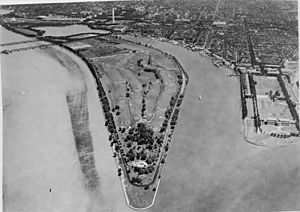
Hains Point is a special place located at the southern tip of East Potomac Park in Washington, D.C.. It sits between the main part of the Potomac River and the Washington Channel. While it looks like a peninsula, it's actually an island! This is because the Washington Channel connects to the Tidal Basin north of the park. Hains Point wasn't here naturally. It was built by people between 1880 and 1892 using material dug from the Potomac River.
A Look Back: History of Hains Point
In 1920, the Girl Scouts started a "tea house" at Hains Point. Back then, traveling by car was a new and exciting adventure. The tea house was a nice stop for tourists. It offered refreshing drinks and snacks, plus restrooms.
Hains Point is named after Peter Conover Hains. He was a Major General in the United States Army. He is buried in Arlington National Cemetery. General Hains was born in 1840 and passed away in 1921. He went to the United States Military Academy at West Point. He is famous for designing the Tidal Basin in Washington, D.C. His design helped solve big drainage problems. It also got rid of bad smells from the marshy areas around Washington.
For many years, Hains Point was home to a large sculpture called The Awakening. This artwork was placed at the Point in 1980. However, the sculpture was moved on February 19, 2008. You can now find it at the National Harbor, Maryland development.
Exploring the Geography of Hains Point
Hains Point is where the Potomac River meets the Anacostia River. From the point, you can see several important places. Across the Washington Channel are Fort Lesley McNair and the National War College. Across the Anacostia River is Bolling Air Force Base. Further northwest on the island, you'll find the Thomas Jefferson Memorial. All these spots are within Washington, D.C. If you look southwest across the Potomac River into Virginia, you can see Ronald Reagan Washington National Airport.
Hains Point and East Potomac Park are managed by the National Mall and Memorial Parks. This is a part of the National Park Service. The park covers about 330 acres (1.3 km²). It has the East Potomac Golf Club and the East Potomac Swimming Pool. You'll also find many of Washington's famous cherry trees here. These beautiful trees stretch all the way into Hains Point.
A concrete path for walking and biking goes around the edge of Hains Point. It also goes around the rest of East Potomac Park. Sometimes, the Potomac and Anacostia Rivers overflow. When this happens during high tide, the path can get covered with water.
A flat road called Ohio Drive loops around East Potomac Park, including Hains Point. This road is one-way inside the park. Cars must drive clockwise. They go northwest along the Potomac River side and southeast along the Washington Channel side. Many different kinds of cherry trees line both sides of this road. Another road, Buckeye Drive, cuts through the middle of the park. It connects the north and south parts of Ohio Drive. Ohio Drive continues beyond the park, following the Potomac River up to the Lincoln Memorial.
As of June 2010, East Potomac Park has 320 parking spaces. You can reach them from both Ohio Drive and Buckeye Drive. On weekends and some holidays, cars are not allowed on parts of Ohio Drive. This stretch of road, including Buckeye Drive, is about 3.2 miles (5.2 km) long. It's a favorite spot for people who love bicycling and inline skating. Hains Point and the park are very popular with people in the D.C. area, especially during the summer.
The land at Hains Point and East Potomac Park is very flat. It only rises to about 10 feet (3 meters) above sea level. This makes it easy for people with mobility challenges to move around and enjoy the park.
See also
 In Spanish: Hains Point para niños
 | Tommie Smith |
 | Simone Manuel |
 | Shani Davis |
 | Simone Biles |
 | Alice Coachman |


