
Hancock, Maine facts for kids
Quick facts for kids
Hancock, Maine
|
|
|---|---|

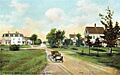
Taunton Bay in 1908
|
|

Hancock, Maine
Location in Maine

Hancock, Maine
Location in the United States
|
|
| Country | United States |
| State | Maine |
| County | Hancock |
| Incorporated | 1828 |
| Villages | Hancock Franklin Road Hancock Point South Hancock |
| Area | |
| • Total | 38.87 sq mi (100.67 km2) |
| • Land | 30.04 sq mi (77.80 km2) |
| • Water | 8.83 sq mi (22.87 km2) |
| Elevation | 95 ft (29 m) |
| Population
(2020)
|
|
| • Total | 2,466 |
| • Density | 31.7/sq mi (12.2/km2) |
| Time zone | UTC-5 (Eastern (EST)) |
| • Summer (DST) | UTC-4 (EDT) |
| ZIP code |
04640
|
| Area code(s) | 207 |
| FIPS code | 23-30970 |
| GNIS feature ID | 0582509 |
| Website | Town of Hancock, Maine |
Hancock is a lovely town located in Hancock County, Maine, in the United States. In 2020, about 2,466 people lived there. The town is on the mainland, right at the top of Frenchman Bay. From Hancock, you can see amazing views of Mount Desert Island.
Contents
History of Hancock
Hancock was first settled in 1766 by Philip and S. Hodgkins. They came from Georgetown. The town was officially created on February 21, 1828. It was formed from parts of nearby towns like Sullivan and Trenton. The town was named after John Hancock, a famous signer of the Declaration of Independence.
The town had two places where water power could run mills. These were the Kilkenny and Egypt streams. People used these mills to make many things. They produced shingles for roofs, lumber, and parts for barrels. They also made boots, shoes, wagons, and sleighs. Many people in Hancock worked on the sea. They were often fishing at the Grand Banks.
During World War II, two German spies landed in Hancock by submarine. Their names were Erich Gimpel and William Colepaugh. They then traveled to New York City. These spies were later caught and faced serious consequences.
Geography of Hancock
Hancock covers a total area of about 38.87 square miles (100.67 square kilometers). About 30.04 square miles (77.80 square kilometers) of this is land. The rest, about 8.83 square miles (22.87 square kilometers), is water.
The town has two main streams, Kilkenny Stream and Egypt Stream. Hancock is located on Skillings River, Taunton Bay, and Frenchman Bay. These are all part of the Atlantic Ocean.
Major roads like U.S. Route 1 and State Route 182 pass through the town. Hancock shares borders with several other towns. These include Lamoine to the south and Ellsworth to the west. It is also near Sullivan and Sorrento across the bays.
Areas within Hancock
The town of Hancock is divided into a few main areas:
- Waukeag Neck: This area includes Hancock Point and South Hancock. It is surrounded by Taunton River and Frenchman's Bay.
- Mid-Hancock (Hancock Hills): This part is mostly along U.S. Route 1. It includes areas like Carrying Place Creek.
- Mud Creek: This is a smaller section near Kilkenny Stream. It has the Mud Creek Marsh.
- Northside: This area is near Egypt Stream and Hog Bay. It includes neighborhoods like Castle Grove.
- Western Hancock: This is the largest land area of the town. It is next to the city of Ellsworth.
Hancock Point is a popular summer spot. It has many old buildings, like the Crocker House Country Inn. Hancock Village is the main part of town. It has the Grammar School, churches, and the town hall.
Hancock is like a central point for Eastern Maine. It is close to Mount Desert Island and the Schoodic Peninsula. These areas are home to parts of Acadia National Park. This makes Hancock a great place to visit or to stay while exploring the region.
Population and People
| Historical population | |||
|---|---|---|---|
| Census | Pop. | %± | |
| 1790 | 278 | — | |
| 1830 | 653 | — | |
| 1840 | 760 | 16.4% | |
| 1850 | 960 | 26.3% | |
| 1860 | 923 | −3.9% | |
| 1870 | 974 | 5.5% | |
| 1880 | 1,093 | 12.2% | |
| 1890 | 1,190 | 8.9% | |
| 1900 | 900 | −24.4% | |
| 1910 | 843 | −6.3% | |
| 1920 | 770 | −8.7% | |
| 1930 | 760 | −1.3% | |
| 1940 | 761 | 0.1% | |
| 1950 | 755 | −0.8% | |
| 1960 | 806 | 6.8% | |
| 1970 | 1,070 | 32.8% | |
| 1980 | 1,409 | 31.7% | |
| 1990 | 1,757 | 24.7% | |
| 2000 | 2,147 | 22.2% | |
| 2010 | 2,394 | 11.5% | |
| 2020 | 2,466 | 3.0% | |
| U.S. Decennial Census | |||
Hancock in 2010
In 2010, there were 2,394 people living in Hancock. There were 1,044 households, which are groups of people living together. About 670 of these were families.
Most people in Hancock were White (96.6%). A small number were African American, Native American, or Asian. About 1.3% of the population was Hispanic or Latino.
The average age in Hancock was 44 years old. About 20% of the people were under 18 years old. About 17.8% were 65 years or older. There were slightly more females (51.3%) than males (48.7%) in the town.
Education in Hancock
Hancock has a few schools:
- Hancock Grammar School
- Pierre Monteux School for Conductors and Orchestra Musicians
Notable Person
- George Haskins (1915–1991), a law professor at the University of Pennsylvania Law School.
Images for kids
-
Street scene circa 1908

See also
 In Spanish: Hancock (Maine) para niños
