Hancock (CDP), New Hampshire facts for kids
Quick facts for kids
Hancock, New Hampshire
|
|
|---|---|

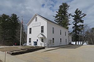
Post Office
|
|
| Country | United States |
| State | New Hampshire |
| County | Hillsborough |
| Town | Hancock |
| Area | |
| • Total | 0.42 sq mi (1.09 km2) |
| • Land | 0.36 sq mi (0.92 km2) |
| • Water | 0.06 sq mi (0.17 km2) |
| Elevation | 870 ft (270 m) |
| Population
(2020)
|
|
| • Total | 213 |
| • Density | 598.31/sq mi (230.93/km2) |
| Time zone | UTC-5 (Eastern (EST)) |
| • Summer (DST) | UTC-4 (EDT) |
| ZIP code |
03449
|
| Area code(s) | 603 |
| FIPS code | 33-33620 |
| GNIS feature ID | 2629724 |
Hancock is a small village in Hillsborough County, New Hampshire, United States. It is known as a census-designated place (CDP). A CDP is a special area defined by the government for counting people. In 2020, about 213 people lived in the Hancock CDP. The entire town of Hancock had a population of 1,731 people.
Contents
Exploring Hancock's Location
The Hancock CDP is right in the middle of the larger town of Hancock. It includes the main village area and the nearby Norway Pond.
The CDP's borders follow some local roads and natural features. For example, it goes along Depot Road, past Norway Pond, and near Moose Brook. It also includes areas near Evergreen Hill Road and Wilder Road.
Main Roads in Hancock
Two important roads, Route 123 and Route 137, meet in the center of Hancock. They share three blocks of Main Street.
- Route 123 goes southeast about 8 miles (13 km) to Peterborough. It also heads northwest about 11 miles (18 km) to Stoddard.
- Route 137 leads northeast about 4 miles (6 km) to Bennington. It also goes southwest about 13 miles (21 km) to Jaffrey.
Land and Water Areas
The Hancock CDP covers a total area of about 0.42 square miles (1.1 square kilometers). Most of this area, about 0.36 square miles (0.9 square kilometers), is land. The rest, about 0.06 square miles (0.17 square kilometers), is water, which includes parts of Norway Pond.
Who Lives in Hancock?
| Historical population | |||
|---|---|---|---|
| Census | Pop. | %± | |
| 2010 | 204 | — | |
| 2020 | 213 | 4.4% | |
| U.S. Decennial Census | |||
Let's look at the people who live in the Hancock CDP.
Population Changes Over Time
In 2010, there were 204 people living in the CDP. By 2020, the population had grown slightly to 213 people.
Households and Families
In 2010, there were 101 households in the CDP. A household is a group of people living together in one home. Out of these, 57 were families. About 22% of households had children under 18 living with them. Many households were made up of individuals living alone, especially those 65 years or older.
Age Groups in the CDP
The people living in Hancock CDP are of different ages:
- About 18% were under 18 years old.
- About 4% were between 18 and 24 years old.
- About 15% were between 25 and 44 years old.
- About 35% were between 45 and 64 years old.
- About 28% were 65 years or older.
The average age in the CDP was about 53 years old.
See also
 In Spanish: Hancock (condado de Hillsborough) para niños
 | Bayard Rustin |
 | Jeannette Carter |
 | Jeremiah A. Brown |


