Harlem, Georgia facts for kids
Quick facts for kids
Harlem, Georgia
|
|
|---|---|

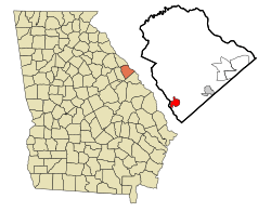
Location in Columbia County and the state of Georgia
|
|
| Country | United States |
| State | Georgia |
| County | Columbia |
| Area | |
| • Total | 6.60 sq mi (17.11 km2) |
| • Land | 6.59 sq mi (17.06 km2) |
| • Water | 0.02 sq mi (0.04 km2) |
| Elevation | 554 ft (169 m) |
| Population
(2020)
|
|
| • Total | 3,571 |
| • Density | 542.05/sq mi (209.28/km2) |
| Time zone | UTC-5 (Eastern (EST)) |
| • Summer (DST) | UTC-4 (EDT) |
| ZIP code |
30814
|
| Area code(s) | 706 |
| FIPS code | 13-36696 |
| GNIS feature ID | 0331913 |
Harlem is a city located in Columbia County, Georgia, in the United States. It's part of the larger Augusta metropolitan area. In 2020, about 3,571 people lived there. Harlem is famous for being the birthplace of the well-known comedian Oliver Hardy. Every year, a special event called the Harlem Oliver Hardy Festival is held in October to celebrate him.
A Look Back: Harlem's History
For many years, especially when the Georgia Railroad was being built, Harlem was known by a different name: Saw Dust. This was likely because of all the wood cutting happening in the area.
Harlem has a special connection with a town in England called Ulverston. These two towns are "twinned," which means they have a friendly partnership. Ulverston is the birthplace of Stan Laurel, who was Oliver Hardy's comedy partner.
Where is Harlem?
Harlem is in the southern part of Columbia County. Its western edge is right next to the McDuffie County border.
Two main roads, U.S. Route 78 and U.S. Route 278, go through the middle of Harlem. If you travel east on these roads, you'll reach downtown Augusta in about 23 miles. Going west, you'll get to Thomson in about 12 miles.
Another important road, U.S. Route 221, crosses US 78/278 in Harlem. Heading north on US 221, you can reach Interstate 20 in about 5 miles and the South Carolina border in about 21 miles. If you go south, you'll arrive in Wrens in about 16 miles.
The city of Harlem covers a total area of about 6.60 square miles (17.11 square kilometers). Most of this area is land, with only a tiny part, about 0.02 square miles (0.04 square kilometers), being water.
Who Lives in Harlem?
The word "demographics" helps us understand the different groups of people who live in a place. Here's how Harlem's population has changed over the years, based on official counts:
| Historical population | |||
|---|---|---|---|
| Census | Pop. | %± | |
| 1880 | 292 | — | |
| 1890 | 647 | 121.6% | |
| 1900 | 527 | −18.5% | |
| 1910 | 736 | 39.7% | |
| 1920 | 798 | 8.4% | |
| 1930 | 784 | −1.8% | |
| 1940 | 736 | −6.1% | |
| 1950 | 1,033 | 40.4% | |
| 1960 | 1,423 | 37.8% | |
| 1970 | 1,540 | 8.2% | |
| 1980 | 1,485 | −3.6% | |
| 1990 | 2,199 | 48.1% | |
| 2000 | 1,814 | −17.5% | |
| 2010 | 2,666 | 47.0% | |
| 2020 | 3,571 | 33.9% | |
| U.S. Decennial Census | |||
The table below shows the different racial groups living in Harlem as of the 2020 United States census. It tells us how many people from each group live there and what percentage they make up of the total population.
| Race | Num. | Perc. |
|---|---|---|
| White (non-Hispanic) | 2,408 | 67.43% |
| Black or African American (non-Hispanic) | 754 | 21.11% |
| Native American | 12 | 0.34% |
| Asian | 24 | 0.67% |
| Pacific Islander | 11 | 0.31% |
| Other/Mixed | 198 | 5.54% |
| Hispanic or Latino | 164 | 4.59% |
In 2020, there were 3,571 people living in Harlem. These people lived in 1,021 different households, and 645 of those households were families.
See also
 In Spanish: Harlem (Georgia) para niños
 | Tommie Smith |
 | Simone Manuel |
 | Shani Davis |
 | Simone Biles |
 | Alice Coachman |

