Harrisburg, Missouri facts for kids
Quick facts for kids
Harrisburg, Missouri
|
|
|---|---|
| Village of Harrisburg | |

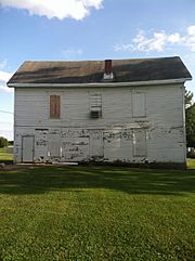
North face of the Harrisburg school and masonic lodge
|
|

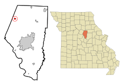
Location of Harrisburg, Missouri
|
|
| Country | United States |
| State | Missouri |
| County | Boone |
| Area | |
| • Total | 0.80 sq mi (2.08 km2) |
| • Land | 0.80 sq mi (2.06 km2) |
| • Water | 0.01 sq mi (0.02 km2) |
| Elevation | 817 ft (249 m) |
| Population
(2020)
|
|
| • Total | 271 |
| • Density | 340.45/sq mi (131.38/km2) |
| Time zone | UTC-6 (Central (CST)) |
| • Summer (DST) | UTC-5 (CDT) |
| ZIP code |
65256
|
| Area code(s) | 573 |
| FIPS code | 29-30484 |
| GNIS feature ID | 2396988 |
Harrisburg is a small village in western Boone County, Missouri, United States. It is part of the Columbia, Missouri area. In 2010, about 266 people lived there.
The village was planned to be an important stop for a railroad. However, the railroad line was never built through Harrisburg. This is why the town stayed small. Harrisburg is located on a high spot between two creeks, Moniteau Creek and Perche Creek. It is also near the start of Callahan Creek. The village is named after John Woods Harris. He was an important leader in the county and owned a large farm nearby.
Contents
History of Harrisburg
Harrisburg got its name from John W. Harris. He owned a farm called the "Model Farm" in an area known as Thrall's Prairie. This was the first permanent settlement in Boone County.
The town was set up along the path of a planned railroad. This railroad was supposed to connect Louisiana and Missouri River areas. However, the plan changed, and the railroad was built farther north instead. You can still see where the old railroad line was supposed to go on maps from 1969.
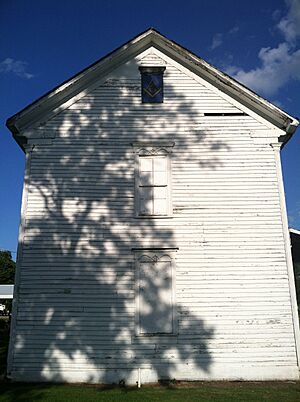
In 1882, Harrisburg had a post office, three stores, a candy shop, a church, a mill, and a blacksmith shop. There was also a public school building. The Freemasons, a fraternal organization, built this school building. It served as Harrisburg’s school and community center from 1878 to 1963. In 2013, it was added to the National Register of Historic Places. Sadly, it was torn down soon after because it was falling apart.
There are two cemeteries in Harrisburg. The small Prewitt Family Cemetery is behind Harrisburg Elementary School. The much larger Harrisburg Cemetery is at the east end of town. The first person was buried there in 1863. Burials still happen today, with about 750 people buried there by 2024.
The first church building in town belonged to the Harrisburg Christian congregation. It was built in 1872 using local stone and donated wood. In 1880, the church had 67 members. The building was replaced with a new one in 1980. The Baptist church in Harrisburg is part of the Southern Baptist Convention. Their old church building, built in 1887, is still used today.
Geography of Harrisburg
Harrisburg is located on Missouri Route 124. It is about one mile from the border between Boone and Howard counties. The town of Fayette is about eleven miles to the west. U.S. Route 63 is about seven miles to the east along Route 124. Perche Creek flows about two miles east of the community.
The village covers a total area of about 0.76 square miles (2.0 square kilometers). Most of this area is land, with a small amount of water. Harrisburg is located between two important water areas: the Moniteau and Perche watersheds. A watershed is an area of land where all the water drains into a common point.
Education in Harrisburg
The Harrisburg R-VIII School District runs an elementary school, a middle school, and Harrisburg High School. In 2009, about 585 students were enrolled in these schools. The high school had a very good graduation rate of 93.3% in 2009.
Harrisburg is also known for its successful basketball teams. The boys' basketball team won the Missouri Class 2A state championship in 2006 and 2008. The girls' basketball team won the Missouri Class 2A state championship in 2010 and 2012.
Population of Harrisburg
| Historical population | |||
|---|---|---|---|
| Census | Pop. | %± | |
| 1880 | 88 | — | |
| 1890 | 135 | 53.4% | |
| 1910 | 146 | — | |
| 1920 | 168 | 15.1% | |
| 1930 | 116 | −31.0% | |
| 1940 | 108 | −6.9% | |
| 1950 | 117 | 8.3% | |
| 1960 | 124 | 6.0% | |
| 1970 | 150 | 21.0% | |
| 1980 | 283 | 88.7% | |
| 1990 | 169 | −40.3% | |
| 2000 | 184 | 8.9% | |
| 2010 | 266 | 44.6% | |
| 2020 | 271 | 1.9% | |
| source: | |||
2010 Census Information
In 2010, the village of Harrisburg had 266 people living in 101 households. Most of the people living in Harrisburg were White (97%). A small number were African American or Native American, or from two or more races.
About 33.5% of the people were under 18 years old. About 31.9% were between 25 and 44 years old. The average age in the village was about 29.8 years.
See also
 In Spanish: Harrisburg (Misuri) para niños
 | James Van Der Zee |
 | Alma Thomas |
 | Ellis Wilson |
 | Margaret Taylor-Burroughs |


