Harrisville, Pennsylvania facts for kids
Quick facts for kids
Harrisville, Pennsylvania
|
|
|---|---|
|
Borough
|
|

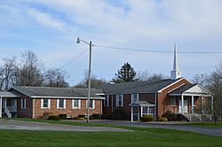
Calvary Orthodox Presbyterian Church on Main Street
|
|

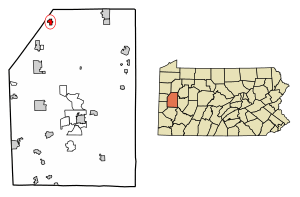
Location of Harrisville in Butler County, Pennsylvania.
|
|
| Country | United States |
| State | Pennsylvania |
| County | Butler |
| Settled | 1826 |
| Incorporated | 1846 |
| Government | |
| • Type | Borough Council |
| Area | |
| • Total | 0.81 sq mi (2.09 km2) |
| • Land | 0.80 sq mi (2.08 km2) |
| • Water | 0.00 sq mi (0.01 km2) |
| Population
(2020)
|
|
| • Total | 819 |
| • Density | 1,018.66/sq mi (393.39/km2) |
| Time zone | UTC-5 (Eastern (EST)) |
| • Summer (DST) | UTC-4 (EDT) |
| Zip code |
16038
|
| Area code(s) | 724 |
| FIPS code | 42-32896 |
Harrisville is a small town, called a borough, located in Butler County, Pennsylvania, United States. In 2010, about 897 people lived there. By 2020, the population was 819.
Contents
History of Harrisville
The land where Harrisville now stands was once used by the Seneca people. They grew corn here because the soil was rich and the land was flat.
In 1797, a man named Col. Robert Reed built a place for travelers to stop. It was a tavern, which is like an inn or restaurant, and a place where drinks were made. This was the first stop for travelers between Pittsburgh and Franklin, Pennsylvania.
Harrisville was officially started in 1826 by Ephraim Harris. Later, in 1846, Harrisville and another small area called Reedsville joined together. This is when Harrisville became an official borough. The town got its first school in 1830, and a high school was built in 1856.
Geography and Location
Harrisville is located near the northwestern edge of Butler County. It sits at coordinates 41.134966 degrees north and 80.009590 degrees west.
Two main roads, Route 8 and Route 58, meet in the middle of Harrisville. Route 8 goes south about 21 miles (34 km) to Butler, which is the county seat. It also goes north about 21 miles (34 km) to Franklin, a city on the Allegheny River.
Route 58 goes east about 18 miles (29 km) to Foxburg, also on the Allegheny River. To the west, it goes about 4 miles (6 km) to Grove City. A small stream called McMurray Run flows through Harrisville. This stream eventually flows into Slippery Rock Creek.
The United States Census Bureau says that Harrisville covers a total area of about 0.81 square miles (2.1 square kilometers). Only a tiny part of this, about 0.004 square miles (0.01 square kilometers), is water.
Population Changes Over Time
The population of Harrisville has changed quite a bit over the years. Here's a quick look at how many people lived there during different census years:
| Historical population | |||
|---|---|---|---|
| Census | Pop. | %± | |
| 1850 | 235 | — | |
| 1860 | 357 | 51.9% | |
| 1870 | 352 | −1.4% | |
| 1880 | 352 | 0.0% | |
| 1890 | 386 | 9.7% | |
| 1900 | 319 | −17.4% | |
| 1910 | 352 | 10.3% | |
| 1920 | 359 | 2.0% | |
| 1930 | 583 | 62.4% | |
| 1940 | 626 | 7.4% | |
| 1950 | 780 | 24.6% | |
| 1960 | 896 | 14.9% | |
| 1970 | 944 | 5.4% | |
| 1980 | 1,033 | 9.4% | |
| 1990 | 862 | −16.6% | |
| 2000 | 883 | 2.4% | |
| 2010 | 897 | 1.6% | |
| 2020 | 819 | −8.7% | |
| Sources: | |||
In 2000, there were 883 people living in Harrisville. There were 323 households, and 231 of these were families. About 28.8% of households had children under 18 living there. The average age of people in Harrisville was 43 years old.
Education
Students in Harrisville attend schools within the Slippery Rock Area School District.
Notable Person
- Ella Hamilton Durley (c. 1852 – 1922) was an important person from Harrisville. She was an educator, a newspaper editor, and a journalist.
See also
 In Spanish: Harrisville (Pensilvania) para niños


