
Harstine Island, Washington facts for kids
Quick facts for kids
Harstine Island, Washington
|
|
|---|---|

Jarrell Cove State Park, Harstine Island
|
|

Harstine Island, Washington
Location in Washington (state)

Harstine Island, Washington
Location in the United States
|
|
| Country | United States |
| State | Washington |
| County | Mason |
| Time zone | UTC-8 (Pacific (PST)) |
| • Summer (DST) | UTC-7 (PDT) |
Harstine Island (also called Harstine or Hartstene) is an island in Mason County, Washington, United States. The US Census calls it an unincorporated community. This means it's a place with a community but no official local government.
The island is located west of Case Inlet in southern Puget Sound. It is about 16 kilometers (10 miles) north of Olympia. Harstine Island has a land area of about 48.3 square kilometers (18.6 square miles). In 2010, 1,412 people lived there.
Pickering Passage is to the northwest, separating the island from the mainland. Case Inlet is to the east, separating it from the Key Peninsula. Squaxin Island is to the southwest, separated by Peale Passage. To the south, Dana Passage separates Harstine Island from the mainland. The island is home to Jarrell Cove State Park and Harstine Island State Park.
Contents
Island History
On August 18, 1838, a group of ships began a trip around the world. This trip was called the Wilkes Expedition. It was led by U.S. Navy Lt. Charles Wilkes. In 1841, the expedition explored the west coast, including Puget Sound. Lt. Wilkes named the island after Lt. Henry J. Hartstene.
From 1922 to 1969, a ferry connected Harstine Island to the mainland. This ferry was owned and run by Mason County, Washington. In 1969, a bridge replaced the ferry, making it easier to reach the island.
Island Name Spelling
For many years, there was no single way to spell the island's name. Even today, you might see different spellings. The most common spellings are Hartstene and Harstine. Other spellings included Harsteen, Harstein, and Hartstein. In 1997, the Washington State Legislature officially made the name Harstine Island.
Lt. Henry J. Hartstene was not part of the Wilkes Expedition when Puget Sound was explored. However, his name was given to the island because he impressed Lt. Wilkes earlier in the voyage. Hartstene had successfully delivered supplies to stranded shipmates.
The spelling of his own name changed over time, which added to the confusion. Before 1855, his name was often spelled 'Hartstein'. After 1855, he started using 'Hartstene'. Maps and official documents then changed to match his preferred spelling.
Getting Around Harstine Island
Harstine Island does not have trains or major highways. You can only get around using local county roads. The closest state highway is State Route 3.
Before the bridge was built in 1969, a ferry served the island. In 1962, it cost 50 cents for a car and its passengers. The bridge was officially opened on June 22, 1969.
Important Landmarks
The Harstine Island Community Hall was built in the early 1900s. It is listed on the National Register of Historic Places. This means it is a special building recognized for its historical importance.
Images for kids
-
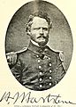
Lt. H.J. Hartstene, for whom the island is named.
_(14580081598).jpg)
See also
 In Spanish: Harstine Island (Washington) para niños
