Hawkins Mountain facts for kids
Quick facts for kids Hawkins Mountain |
|
|---|---|

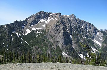
Hawkins Mountain, northeast aspect
|
|
| Highest point | |
| Elevation | 7,160 ft (2,180 m) |
| Prominence | 1,520 ft (460 m) |
| Isolation | 2.74 mi (4.41 km) |
| Parent peak | Ingalls Peak (7,662 ft) |
| Geography | |
| Location | Kittitas County Washington, U.S. |
| Parent range | Wenatchee Mountains Cascade Range |
| Topo map | USGS Davis Peak, Mount Stuart |
| Type of rock | volcanic serpentine, basalt |
| Climbing | |
| First ascent | September 8, 1899 Bailey Willis party |
| Easiest route | class 2 hiking South slope |
Hawkins Mountain is a big mountain in Kittitas County, Washington state. It stands 7,160+ ft (2,180+ m) tall and has two main peaks. It's the sixth-highest point in the Teanaway area of the Wenatchee Mountains. The lower peak, which is 7,080 ft (2,160 m) high, is sometimes called Hawkins Thimble.
Hawkins Mountain is located about three miles southwest of Ingalls Peak. It's also 1.7 mi (2.7 km) northwest of Esmeralda Peaks. This mountain is part of the land managed by the Wenatchee National Forest. Rain and melting snow from the mountain flow into the Teanaway River and Cle Elum River. The mountain was named after a person named Samuel S. Hawkins, who was a prospector.
Weather Around Hawkins Mountain
The area around Hawkins Mountain is a bit drier than places to the west. This is because it's located on the eastern side of the Cascade Range.
Summer Weather
During the summer, it can get quite warm. Sometimes, there are even thunderstorms.
Winter Weather
Most of the time, weather systems come from the Pacific Ocean. They travel east towards the Cascade Mountains. When these weather systems hit the tall Cascade peaks, they are forced to rise. As they go higher, they drop their moisture as rain or snow on the western side of the mountains. This means the eastern side, where Hawkins Mountain is, gets less rain and snow.
In winter, the weather is usually cloudy. But in summer, high-pressure systems over the Pacific Ocean often bring clear skies with little to no clouds.
 | Frances Mary Albrier |
 | Whitney Young |
 | Muhammad Ali |


