
Hayward Executive Airport facts for kids
Quick facts for kids
Hayward Executive Airport
(former Hayward Army Air Field)
|
|||||||||||||||
|---|---|---|---|---|---|---|---|---|---|---|---|---|---|---|---|

USGS 2006 orthophoto
|
|||||||||||||||
| Summary | |||||||||||||||
| Airport type | Public | ||||||||||||||
| Owner | City of Hayward | ||||||||||||||
| Serves | Hayward, California | ||||||||||||||
| Elevation AMSL | 52 ft / 16 m | ||||||||||||||
| Coordinates | 37°39′32″N 122°07′18″W / 37.65889°N 122.12167°W | ||||||||||||||
| Website | www.hayward-ca.gov/airport | ||||||||||||||
| Maps | |||||||||||||||
 FAA diagram |
|||||||||||||||

HWD
Location in California
|
|||||||||||||||
| Runway | |||||||||||||||
|
|||||||||||||||
| [[Helipad|]] | |||||||||||||||
|
|||||||||||||||
| Statistics (2010) | |||||||||||||||
|
|||||||||||||||
|
Source: Federal Aviation Administration
|
|||||||||||||||
Hayward Executive Airport (HWD) is a public airport in Hayward, California. It is located near the beautiful San Francisco Bay. This airport is important because it helps reduce air traffic at bigger airports nearby. It used to be called Hayward Air Terminal.
Contents
Airport History
Building the Airport
Hayward Executive Airport was built in 1942, during World War II. It was first known as Hayward Army Air Field. It served as a support airfield for Chico Army Air Field. The main planes flown from here were Lockheed P-38 Lightnings. The airfield was part of the United States Army Air Forces.
After the War
After World War II ended, the airport was no longer needed by the military. In April 1947, the land and buildings were given to the City of Hayward. The airport was then renamed Hayward Municipal Airport.
California Air National Guard
In 1949, the California Air National Guard moved to land next to the airport. They first had the 61st Fighter Wing, which included the 194th Fighter Squadron.
The 61st Fighter Wing later became the 144th Fighter Bomber Wing in 1950. This wing also included squadrons from Reno, Nevada and Salt Lake City, Utah.
From 1948 to 1954, planes like the North American Aviation P-51 Mustang were flown here. The unit was known for being good at aerial gunnery (shooting targets from planes). In 1953, they even competed in a worldwide gunnery meet using borrowed North American Aviation F-86 Sabre jets. This unit later moved to Fresno.
In 1955, the 129th Air Resupply Squadron started at Hayward. They used Curtiss C-46 Commando planes and later HU-16 Albatross planes. A control tower was built in 1960. The unit grew into the 129th Troop Carrier Group in 1962.
By 1980, the remaining California Air National Guard units at Hayward moved to Moffett Federal Airfield near San Jose. Today, this unit is known as the 129th Rescue Wing.
Airport Facilities
The airport covers about 543 acres (220 ha) of land. It is 52 feet (16 meters) above sea level.
Runways and Helipads
Hayward Executive Airport has two asphalt runways:
- Runway 10R/28L is 5,694 feet (1,736 meters) long and 150 feet (46 meters) wide.
- Runway 10L/28R is 3,107 feet (947 meters) long and 75 feet (23 meters) wide.
It also has one helipad (H1) for helicopters, which is 110 by 110 feet (34 by 34 meters).
Airport Activity
In 2010, the airport had 86,069 aircraft operations. This means about 235 planes took off or landed each day. Most of these (98%) were general aviation flights, which are private or business flights. About 2% were air taxi flights.
At that time, 368 aircraft were based at the airport. Most of these (82%) were single-engine planes. There were also multi-engine planes (11%), jets (4%), and helicopters (3%).
Other Services
Since 2012, the Northern California part of Ameriflight has been located at Hayward Executive Airport. Ameriflight is a company that flies cargo.
The airport plans to build a new administration building. The current offices are in the five-story control tower built in 1961. The new building will be next to the control tower and will be almost 5,000 square feet.
Gallery
-
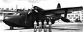
A U.S. Air Force Grumman HU-16 Albatross amphibian with its crew. The aircraft was assigned to the 129th Air Commando Group, California Air National Guard at Hayward Airport from 1963 to 1968.
-
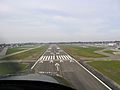
Short-final on KHWD 28L
-
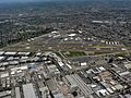
Looking northeast


See also
 In Spanish: Aeropuerto Ejecutivo de Hayward para niños
