
Hazardville, Connecticut facts for kids
Quick facts for kids
Hazardville, Connecticut
|
|
|---|---|

Main Street in Hazardville, circa 1906
|
|

Hazardville, Connecticut
Location in Connecticut

Hazardville, Connecticut
Location in the United States
|
|
| Country | United States |
| State | Connecticut |
| County | Hartford |
| Town | Enfield |
| Area | |
| • Total | 3.3 sq mi (8.5 km2) |
| • Land | 3.3 sq mi (8.5 km2) |
| • Water | 0 sq mi (0.0 km2) |
| Elevation | 180 ft (50 m) |
| Population
(2010)
|
|
| • Total | 4,599 |
| • Density | 1,401/sq mi (541/km2) |
| Time zone | UTC-5 (Eastern) |
| • Summer (DST) | UTC-4 (Eastern) |
| ZIP code |
06082
|
| Area code(s) | 860 |
| FIPS code | 09-37770 |
| GNIS feature ID | 2377824 |
Hazardville is a part of the town of Enfield, Connecticut. It is located in Hartford County. Hazardville is also a census-designated place (CDP). This means it is a specific area that the government defines for counting people and gathering information. In 2010, about 4,599 people lived in Hazardville.
Contents
History of Hazardville
Hazardville started as a busy place for factories. These factories mainly made gunpowder. They used the power of the Scantic River to run their machines. The very first small factory for making black powder was built in 1835. It was started by Allen Loomis in an area called Powder Hollow. This factory later became known as the Hazard Powder Company.
Hazardville got its name from a person named Colonel Augustus George Hazard. He was important to the area's history.
Hazardville's Historic District
A large area in and around Hazardville is known as the Hazardville Historic District. This district was added to the National Register of Historic Places in 1980. This means it is a special area recognized for its important history. The district includes old factory sites and other historical places along the Scantic River.
Geography of Hazardville
The Hazardville CDP includes the original village of Hazardville. It also has newer neighborhoods that have grown up east of the old railroad line. This area stretches all the way to the town line of Somers.
According to the United States Census Bureau, the total area of Hazardville is about 8.5 square kilometers (3.3 square miles). All of this area is land. There is no water within the CDP boundaries.
A part of the Scantic River State Park is located in the Powder Hollow section of Hazardville. This park offers natural beauty and outdoor activities.
People of Hazardville
In 2000, there were about 4,900 people living in Hazardville. These people lived in 1,832 households, which are like homes or apartments. About 1,337 of these households were families.
The population density was about 575 people for every square kilometer. This means a lot of people live in a relatively small area.
Most of the people in Hazardville were White (95.45%). There were also African American (1.41%), Asian (1.41%), and Native American (0.22%) residents. Some people identified as two or more races (1.04%). About 1.41% of the population was Hispanic or Latino.
Many households (32.4%) had children under 18 living with them. Most households (59.4%) were married couples living together. About 22.3% of all households were made up of people living alone.
The age of the people in Hazardville varied. About 24.3% were under 18 years old. About 18.1% were 65 years or older. The average age was 40 years old. For every 100 females, there were about 94.5 males.
Images for kids
-
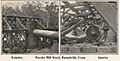
Powder mill wreckage, c. 1906
-
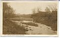
Powder Hollow, c. 1910
-
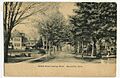
School Street, looking north, c. 1910
-
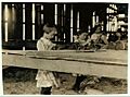
Child laborers in a tobacco shed at Hawthorn Farm in Hazardville, 1917. Photo by Lewis Hine.


See also
 In Spanish: Hazardville (Connecticut) para niños
