Henderson, North Carolina facts for kids
Quick facts for kids
Henderson, North Carolina
|
|||
|---|---|---|---|

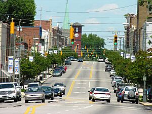
Downtown Henderson
|
|||
|
|||
| Nicknames:
The Gateway City, Triangle North, Lil’ Durham, The Gate's
|
|||
| Motto(s):
"Progress, Pride, Potential"
|
|||

Location of Henderson, North Carolina
|
|||
| Country | United States | ||
| State | North Carolina | ||
| County | Vance | ||
| Named for | Leonard Henderson | ||
| Government | |||
| • Type | Municipality | ||
| Area | |||
| • Total | 8.63 sq mi (22.35 km2) | ||
| • Land | 8.62 sq mi (22.34 km2) | ||
| • Water | 0.01 sq mi (0.01 km2) | ||
| Elevation | 440 ft (130 m) | ||
| Population
(2020)
|
|||
| • Total | 15,060 | ||
| • Density | 1,746.29/sq mi (674.21/km2) | ||
| Demonym(s) | Hendersonian | ||
| Time zone | UTC−5 (Eastern (EST)) | ||
| • Summer (DST) | UTC−4 (EDT) | ||
| ZIP codes |
27536-27537
|
||
| Area code(s) | 252 | ||
| FIPS code | 37-30660 | ||
| GNIS feature ID | 2404683 | ||
| Website | henderson.nc.gov | ||
Henderson is a city in North Carolina, United States. It is the main city, or county seat, of Vance County. In 2020, about 15,060 people lived there.
Contents
History of Henderson
The city of Henderson was named after Leonard Henderson. He was a very important judge in North Carolina. The city was officially started in 1841.
Before 1881, Henderson was part of Granville County. Later, Vance County was created, and Henderson became its main city.
Many historic places in Henderson are listed on the National Register of Historic Places. These include Ashland and the Henderson Central Business Historic District. These buildings show the city's long history.
Geography and Location
Henderson is located in North Carolina. It covers about 8.6 square miles (22.3 square kilometers) of land. Only a tiny part is water.
The city is easy to reach because it is close to major highways. These include Interstate 85 and U.S. 1. Highway 39 also goes through Henderson.
Population Changes Over Time
| Historical population | |||
|---|---|---|---|
| Census | Pop. | %± | |
| 1860 | 186 | — | |
| 1870 | 1,635 | 779.0% | |
| 1880 | 1,421 | −13.1% | |
| 1890 | 4,191 | 194.9% | |
| 1900 | 3,746 | −10.6% | |
| 1910 | 4,503 | 20.2% | |
| 1920 | 5,222 | 16.0% | |
| 1930 | 6,345 | 21.5% | |
| 1940 | 7,647 | 20.5% | |
| 1950 | 10,996 | 43.8% | |
| 1960 | 12,740 | 15.9% | |
| 1970 | 13,896 | 9.1% | |
| 1980 | 13,522 | −2.7% | |
| 1990 | 15,655 | 15.8% | |
| 2000 | 16,095 | 2.8% | |
| 2010 | 15,368 | −4.5% | |
| 2020 | 15,060 | −2.0% | |
| 2021 (est.) | 14,954 | −2.7% | |
| U.S. Decennial Census | |||
The population of Henderson has changed a lot over the years. In 1860, only 186 people lived there. By 2020, the population had grown to 15,060 people.
Many different people live in Henderson. In 2020, there were 15,060 people living in 5,715 households.
Transportation in Henderson
Rail Travel
Henderson is on the S-Line, which is a railway line. This line used to be a main route for trains. It is now owned by CSX Transportation.
Passenger trains stopped using this line in 1986. However, there are plans to bring passenger rail service back. This is part of a bigger project to create a high-speed rail corridor.
Education in Henderson
All the public schools in Henderson are part of the Vance County Schools district. This district serves the entire county.
Notable People from Henderson
Many interesting people have come from Henderson. Here are a few:
- Gerald Alston (born 1951), a singer in the R&B group The Manhattans.
- Charlotte Hawkins Brown (1883–1961), an important educator. She founded the Palmer Institute.
- Jason Brown (born 1983), a professional football player. He played for the St. Louis Rams.
- Ben E. King (1938–2015), a famous soul and pop singer. He sang the hit song "Stand by Me."
- Charlie Rose (born 1942), a well-known television talk show host and journalist. He was born and grew up in Henderson.
See also
 In Spanish: Henderson (Carolina del Norte) para niños
 | William L. Dawson |
 | W. E. B. Du Bois |
 | Harry Belafonte |


