Het Bildt facts for kids
Quick facts for kids
het Bildt
|
|||
|---|---|---|---|

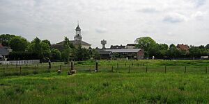
Church and water tower of Sint Jacobiparochie
|
|||
|
|||

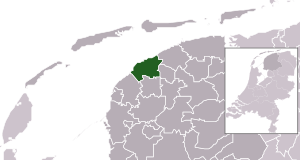
Location in Friesland
|
|||
| Country | Netherlands | ||
| Province | Friesland | ||
| Government | |||
| • Body | Municipal council | ||
| Area | |||
| • Total | 116.48 km2 (44.97 sq mi) | ||
| • Land | 92.37 km2 (35.66 sq mi) | ||
| • Water | 24.11 km2 (9.31 sq mi) | ||
| Elevation | 1 m (3 ft) | ||
| Time zone | UTC+1 (CET) | ||
| • Summer (DST) | UTC+2 (CEST) | ||
| Postcode |
9047, 9075–9079
|
||
| Area code | 0518 | ||
Het Bildt was a special area and a former municipality in the northern Netherlands. It was located in the province of Friesland. The main town was Sint Annaparochie. On January 1, 2018, Het Bildt joined with other municipalities to form a new one called Waadhoeke.
This area has about 15.4 kilometers (9.6 miles) of coastline. The soil here is very rich and good for growing crops. Farming is a big part of the local economy. Farmers grow things like onions, potatoes, and different kinds of fruits, especially apples.
Many of the first people who settled in Het Bildt came from a different part of the Netherlands called South Holland. Because of this, the language spoken there is unique. It's called "Bildts". This language mixes words from Dutch (like it was spoken in South Holland) with words from West Frisian. Bildts is usually seen as a dialect of Dutch. In Het Bildt, you can hear all three languages: Bildts, Dutch, and West Frisian. Only in Minnertsga, which became part of Het Bildt later, is West Frisian the main language. Road signs in Het Bildt often show names in both Dutch and Bildts.
The name "Het Bildt" comes from the word opbilden. This word means the "silting up of land". It describes how new land is formed when mud and sand build up from the sea.
Contents
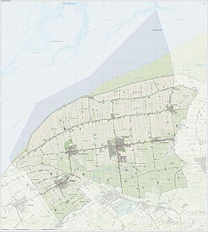
What Towns are in Het Bildt?
Het Bildt was made up of several towns and villages. Here are the populations as of January 1, 2004:
| Dutch name | Bildts name | West Frisian name | Population |
| Sint Annaparochie | Sint-Anne | Sint Anne | 3990 |
| Minnertsga | Minnertska | Minnertsgea | 1640 |
| Sint Jacobiparochie | Sint-Jabik | Sint Jabik | 1370 |
| Oudebildtzijl | Ouwe-Syl | Aldebildtsyl | 740 |
| Vrouwenparochie | Froubuurt | Froubuorren | 620 |
| Nij Altoenae | Nij Altoenae | Nij Altena | 280 |
| Westhoek | De Westhoek | De Westhoek | 280 |
Source: CBS
How Was Het Bildt Formed?
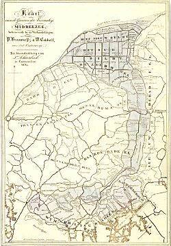
The area we now call Het Bildt used to be a sea called the Middelsee. This sea often flooded the land. The Middelsee separated the western part of Friesland, called Westergoa, from the eastern part, Eastergoa.
Around the year 1300, the sea started to become less deep. People built a dike (a wall to hold back water) between the villages of Beetgumermolen and Britsum. This dike stopped the floods. The land south of the dike became dry and solid. This connected Westergoa and Eastergoa for the first time! A small river called the Swette was kept to connect Leeuwarden and Sneek.
After this first dike, the northern part of the Middelsee also slowly filled up with mud and sand. In 1398, the new dry lands were given to a lord named Arnold I, Lord of Egmond. By 1498, even more land had become dry. This process of land forming from the sea continues even today, thanks to the tides of the Waddenzee.
Who Built the Dikes?
The new dry land was divided into two parts: "Het Grote Bildt" and "Het Kleine Bildt". Both parts belonged to Duke Albert of Saxony-Meissen. He wanted to turn the whole area into solid land, but he ran out of money and died in 1504.
In 1505, Duke George of Saxony (Albert's brother) made a deal with some noble brothers from South Holland: Dirk, Floris, and Jakob van Wijngaarden, and their brother-in-law Thomas Beukelaar. These brothers started the huge project of building dikes.
They faced many challenges, as the tides kept flooding the land. But with more money from Duke George and help from two other nobles, they finally managed to dike the area properly. "Het Bildt" was protected by a 14-kilometer (about 8.7 miles) long dike. This amazing work was done by hand, using spades, boats, and mud. Many workers from South Holland, Zeeland, and Friesland helped. The area was planned very carefully, with straight roads running north-south or east-west.
The Villages of Het Bildt
Along the main road, three villages were created. They were named Wijngaarden, Altoenae, and Kijfhoek. These names came from villages in South Holland, where most of the workers were from. Over time, these villages became Catholic parishes (church communities). The names of these parishes eventually became the names of the villages we know today: Sint Jacobiparochie, Sint Annaparochie, and Vrouwenparochie.
Later, in 1514, Duke George of Saxony had to give the whole Bildt area to the Count of Holland and Zeeland. This happened with the permission of Charles V.
When the "Republic of the Seven United Netherlands" fought for its freedom from Spain, Het Bildt became the 29th county of Friesland.
More Dikes and Land
It was later decided that the area north of the first dike should also be protected. This new dike, built around 1600, was called the "Nieuwe Bildtdijk" (New Bildt Dike). The original 14-kilometer dike was then called the "Oude Bildtdijk" (Old Bildt Dike). The land between these two dikes was called "Nij Bildt" (New Bildt). In 1637, this new land was sold because the province of Friesland needed money.
It's believed that the special design of Frisian farmhouses, which you can see all over Friesland, actually started in Het Bildt. The people from South Holland brought the design with them, and it was later used across the province.
In 1715, another area to the west was diked, called the "Wester Bildtpollen". The rest of this area was sold in 1751. In 1754, the eastern part, the "Ooster Bildtpollen", was also diked.
Today, both the "Oude Bildtdijk" and the "Nieuwe Bildtdijk" have roads and houses on them. The road that runs along the old 14-kilometer dike is actually the longest road in the Netherlands!
See also
 In Spanish: Het Bildt para niños
 | DeHart Hubbard |
 | Wilma Rudolph |
 | Jesse Owens |
 | Jackie Joyner-Kersee |
 | Major Taylor |


