Hett, County Durham facts for kids
Quick facts for kids Hett |
|
|---|---|
 |
|
| Civil parish | |
| Unitary authority |
|
| Ceremonial county | |
| Region | |
| Country | England |
| Sovereign state | United Kingdom |
| EU Parliament | North East England |
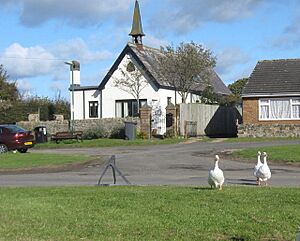
Hett is a small village in County Durham, England. It's located just a few miles south of the city of Durham. Hett is mostly surrounded by green farmland.
If you visit Hett, you'll see fields of bright yellow rape plants to the south. To the north, you might spot cattle grazing all year round. A small area called Sunderland Bridge, with fewer than 50 people, is to the north-west. The village itself has a small pond, a village hall, and a football pitch where local games are played.
Hett is also known in geology for something special: it gives its name to an igneous dyke. This is like a wall of rock that cuts through the older Coal Measures rocks in the area. Politically, Hett is part of the City of Durham area for the UK Parliament.
What Does the Name Hett Mean?
The name Hett comes from an old English word, hætt. This word means "a hat."
It's believed that the village was named this way because it sits near a hill that looks a bit like a hat! So, the name describes a feature of the local landscape.
Hett's History as a Parish
Hett used to be a small area called a "township" within a larger parish called Merrington. A civil parish is a local area with its own council, helping to manage local services.
In 1866, Hett became its own official civil parish. This meant it had its own local administration. However, on April 1, 1986, the Hett parish joined with another area. It became part of a new, larger parish called "Croxdale & Hett." In 1961, the Hett parish had a population of 148 people.
 | Stephanie Wilson |
 | Charles Bolden |
 | Ronald McNair |
 | Frederick D. Gregory |

